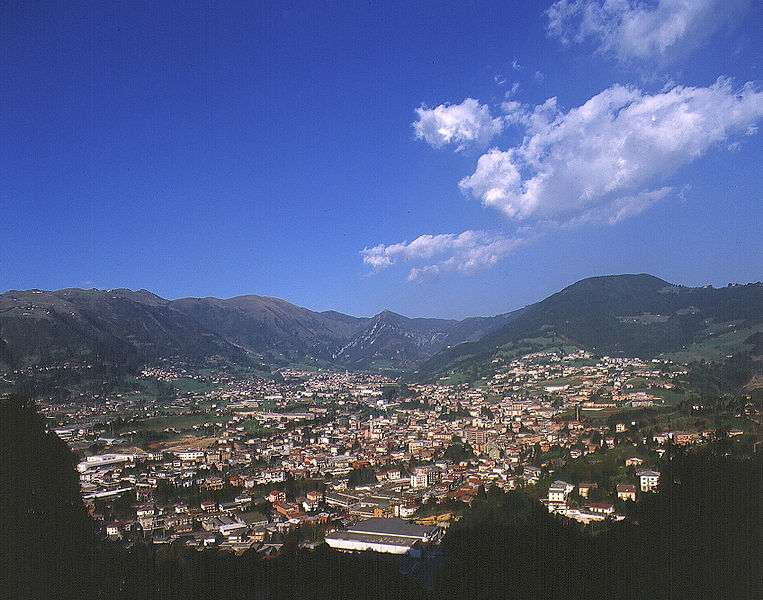
Клузоне (Clusone, Clusone)
.svg)
- коммуна Италии
 Hiking in Клузоне
Clusone is a charming town located in the Italian Alps, within the province of Bergamo in Lombardy. It's a wonderful area for hiking, offering a mix of scenic beauty, cultural landmarks, and varying levels of trails suitable for different experience levels.
Hiking Trails and Areas Around Clusone
-
Monte Farno: This mountain provides several trails that cater to hikers of all abilities. The views from the summit are breathtaking, offering panoramic vistas of the surrounding Alps and valleys.
-
Valle Seriana: The Seriana Valley offers a plethora of hiking paths that wind through lush landscapes, forests, and past small lakes. This area is known for its natural beauty and tranquility.
-
Sentiero dei Vultur: This is a scenic trail that offers a more challenging hike, providing a unique experience as you traverse through diverse terrains and enjoy views of the surrounding mountains.
-
Cime di Valgandino: This area is renowned for its beautiful landscapes and is ideal for moderate to challenging hikes. The trails here take you through alpine meadows and forests, with opportunities for wildlife sightings.
Tips for Hiking in Clusone
-
Season: The best time to hike in Clusone is during the spring and early autumn months, as summer can be warm, and winter may lead to snow on the higher trails.
-
Preparation: Always check the weather before your hike and ensure you have appropriate gear, including sturdy hiking boots, weather-appropriate clothing, and plenty of water.
-
Maps and Guides: It’s a good idea to carry a map or a GPS device, as some trails may not be well-marked. Consider hiring a local guide for a more in-depth experience of the area.
-
Local Cuisine: After a day's hike, enjoy the local cuisine in Clusone’s restaurants. You’ll find traditional dishes that will refuel you after your outdoor adventures.
-
Cultural Highlights: Don’t miss the chance to explore Clusone itself, which is known for its historical architecture, including the Colleoni Chapel and the Astronomical Clock.
Hiking in Clusone not only offers physical challenges and beautiful landscapes but also a rich cultural experience. Always ensure safety first and enjoy your adventure in this picturesque part of Italy!
- Страна:

- Почтовый код: 24023
- Телефонный код: 0346
- Код автомобильного номера: BG
- Координаты: 45° 53' 0" N, 9° 57' 0" E


- GPS треки (wikiloc): [Ссылка]
- Высота над уровнем моря: 647 м m
- Площадь: 25 кв.км
- Население: 8625
- Веб сайт: http://comune.clusone.bg.it/
- Википедия русская: wiki(ru)
- Википедия английская: wiki(en)
- Википедия национальная: wiki(it)
- Хранилище Wikidata: Wikidata: Q100388
- Галерея изображений в википедии: [Ссылка]
- Катеория в википедии: [Ссылка]
- код Freebase: [/m/0drr2v]
- код GeoNames: Альт: [6537149]
- код VIAF: Альт: [144786469]
- ID отношения в OpenStreetMap: [46343]
- идентификатор местоположения ArchINFORM: [45511]
- место в MusicBrainz: [edf71b7e-a7b0-4035-95b6-07bfb3893637]
- код темы Quora: [Clusone]
- UN/LOCODE: [ITCUE]
- код ISTAT: 016077
- кадастровый код Италии: C800
Граничит с регионами:

Гандино
- коммуна Италии
Hiking in Гандино
Gandino is a charming village located in the province of Bergamo, Lombardy, Italy. Nestled in the Seriana Valley and surrounded by stunning mountain landscapes, it offers a variety of hiking opportunities for outdoor enthusiasts. Here are some key aspects to consider when hiking in Gandino:...
- Страна:
- Почтовый код: 24024
- Телефонный код: 035
- Код автомобильного номера: BG
- Координаты: 45° 48' 42" N, 9° 54' 11" E
- GPS треки (wikiloc): [Ссылка]
- Высота над уровнем моря: 553 м m
- Площадь: 29.03 кв.км
- Население: 5390
- Веб сайт: [Ссылка]


Ольтрессенда-Альта
- коммуна Италии
Hiking in Ольтрессенда-Альта
Oltressenda Alta is a beautiful area in the Italian Alps, part of the Bergamo province in Lombardy. This region offers breathtaking landscapes, rich natural beauty, and a variety of hiking options suitable for different skill levels. Here are some highlights and tips for hiking in Oltressenda Alta:...
- Страна:
- Почтовый код: 24020
- Телефонный код: 0346
- Код автомобильного номера: BG
- Координаты: 45° 55' 0" N, 9° 56' 0" E
- GPS треки (wikiloc): [Ссылка]
- Высота над уровнем моря: 714 м m
- Площадь: 17.33 кв.км
- Население: 146
- Веб сайт: [Ссылка]


Парре
- коммуна Италии
Hiking in Парре
Parre, a small town in the province of Bergamo, Italy, offers a charming backdrop for hikers with its stunning landscapes, picturesque views, and various trails. It's nestled in the Seriana Valley, surrounded by the captivating Orobie Mountains, which provide ample hiking opportunities for enthusiasts of all levels....
- Страна:
- Почтовый код: 24020
- Телефонный код: 035
- Код автомобильного номера: BG
- Координаты: 45° 52' 0" N, 9° 54' 0" E
- GPS треки (wikiloc): [Ссылка]
- Высота над уровнем моря: 650 м m
- Площадь: 22.28 кв.км
- Население: 2732
- Веб сайт: [Ссылка]


Пьярио
- коммуна Италии
Hiking in Пьярио
Piario, located in the Lombardy region of Italy, is surrounded by stunning natural landscapes, making it a great destination for hiking enthusiasts. Nestled in the Seriana Valley, the area features a mix of mountainous terrain, wooded areas, and picturesque villages which offer a variety of hiking options suitable for different skill levels....
- Страна:
- Почтовый код: 24020
- Телефонный код: 0346
- Код автомобильного номера: BG
- Координаты: 45° 53' 46" N, 9° 55' 26" E
- GPS треки (wikiloc): [Ссылка]
- Высота над уровнем моря: 539 м m
- Площадь: 1.55 кв.км
- Население: 1074
- Веб сайт: [Ссылка]


Понте-Носса
- коммуна Италии
Hiking in Понте-Носса
Ponte Nossa is a picturesque town located in the Lombardy region of northern Italy, part of the Bergamo province. Surrounded by the stunning Orobie Alps, it offers a variety of hiking opportunities, making it an excellent destination for both novice and experienced hikers....
- Страна:
- Почтовый код: 24028
- Телефонный код: 035
- Код автомобильного номера: BG
- Координаты: 45° 52' 0" N, 9° 53' 0" E
- GPS треки (wikiloc): [Ссылка]
- Высота над уровнем моря: 465 м m
- Площадь: 5.59 кв.км
- Население: 1761
- Веб сайт: [Ссылка]


Роветта
- коммуна Италии
Hiking in Роветта
Rovetta, located in the Bergamasque Alps of northern Italy, offers a fantastic hiking experience due to its stunning landscapes, charming village atmosphere, and variety of trails suited for different skill levels....
- Страна:
- Почтовый код: 24020
- Телефонный код: 0346
- Координаты: 45° 53' 0" N, 9° 59' 0" E
- GPS треки (wikiloc): [Ссылка]
- Высота над уровнем моря: 650 м m
- Площадь: 24.53 кв.км
- Население: 4168
- Веб сайт: [Ссылка]


Вилла-д'Онья
- коммуна Италии
Hiking in Вилла-д'Онья
Villa d'Ogna is a charming village located in the province of Bergamo, Lombardy, Italy. Nestled in the scenic Val Seriana valley, it offers a range of hiking opportunities that allow you to explore the stunning natural landscape of the region....
- Страна:
- Почтовый код: 24020
- Телефонный код: 0346
- Код автомобильного номера: BG
- Координаты: 45° 54' 0" N, 9° 56' 0" E
- GPS треки (wikiloc): [Ссылка]
- Высота над уровнем моря: 542 м m
- Площадь: 5.16 кв.км
- Население: 1869
- Веб сайт: [Ссылка]