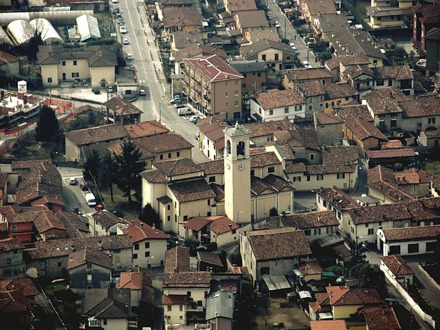
Коллебеато (Collebeato, Collebeato)
.svg)
- коммуна Италии
 Hiking in Коллебеато
Collebeato is a small town located near Brescia in Italy, and it's a great spot for hiking enthusiasts looking for beautiful natural landscapes and a peaceful environment. The area around Collebeato offers a range of trails that cater to different skill levels, making it suitable for both beginners and experienced hikers.
Here are some highlights of hiking in Collebeato:
-
Spectacular Views: The region provides stunning panoramic views of Brescia and the surrounding valleys. Many trails lead to elevated viewpoints that allow hikers to enjoy the beauty of the Lombardy landscape.
-
Variety of Trails: You can find well-marked trails ranging from easy walks to more challenging paths. Popular routes often include nature trails that take you through wooded areas, rolling hills, and meadows.
-
Nature and Wildlife: The flora and fauna in the area are diverse, and you may encounter various plant species, birds, and other wildlife. This makes hiking in Collebeato not only a physical activity but also an opportunity for nature observation.
-
Cultural Sites: Along some hiking routes, you may come across historical landmarks, such as old churches and ruins, which add a cultural dimension to your hiking experience.
-
Accessibility: Collebeato is easily accessible from Brescia, making it a convenient starting point for your hiking adventures in the region.
-
Additional Activities: Aside from hiking, the area might offer opportunities for mountain biking, picnicking, and enjoying local cuisine in nearby restaurants or cafés.
When planning your hike, always consider checking local maps and guides, and ensure you are adequately prepared with suitable footwear, water, snacks, and sun protection. It's also a good idea to check the weather conditions before heading out and to familiarize yourself with the chosen trail's difficulty and length. Happy hiking!
- Страна:

- Почтовый код: 25060
- Телефонный код: 030
- Код автомобильного номера: BS
- Координаты: 45° 35' 0" N, 10° 13' 0" E


- GPS треки (wikiloc): [Ссылка]
- Высота над уровнем моря: 200 м m
- Площадь: 5.27 кв.км
- Население: 4654
- Веб сайт: http://www.comune.collebeato.bs.it
- Википедия русская: wiki(ru)
- Википедия английская: wiki(en)
- Википедия национальная: wiki(it)
- Хранилище Wikidata: Wikidata: Q104050
- Катеория в википедии: [Ссылка]
- код Freebase: [/m/041wbf]
- код GeoNames: Альт: [6542596]
- код VIAF: Альт: [154244335]
- ID отношения в OpenStreetMap: [45405]
- UN/LOCODE: [ITCLL]
- код ISTAT: 017057
- кадастровый код Италии: C850
Граничит с регионами:
Челлатика
- коммуна Италии
Hiking in Челлатика
Cellatica is a charming area located in the Lombardy region of Italy, specifically near the southern slopes of the Alps and close to Lake Iseo. The natural landscapes around Cellatica offer a variety of hiking opportunities, making it an attractive destination for outdoor enthusiasts....
- Страна:
- Почтовый код: 25060
- Телефонный код: 030
- Код автомобильного номера: BS
- Координаты: 45° 35' 0" N, 10° 11' 0" E
- GPS треки (wikiloc): [Ссылка]
- Высота над уровнем моря: 170 м m
- Площадь: 6.55 кв.км
- Население: 4903
- Веб сайт: [Ссылка]
Кончезьо
- коммуна Италии
Hiking in Кончезьо
Concesio, a municipality in the Lombardy region of Italy, offers some lovely hiking opportunities that take advantage of its picturesque countryside and proximity to the stunning surrounding landscapes. Here are some key points about hiking in the Concesio area:...
- Страна:
- Почтовый код: 25062
- Телефонный код: 030
- Код автомобильного номера: BS
- Координаты: 45° 36' 0" N, 10° 13' 0" E
- GPS треки (wikiloc): [Ссылка]
- Высота над уровнем моря: 216 м m
- Площадь: 19.08 кв.км
- Население: 15672
- Веб сайт: [Ссылка]

Брешиа
- коммуна Италии, город
Hiking in Брешиа
Brescia, located in northern Italy, is surrounded by stunning landscapes and offers a variety of hiking opportunities for all skill levels. The area is characterized by its beautiful hills, the nearby Alps, and picturesque lakes—most notably Lake Garda to the west....
- Страна:
- Почтовый код: 25121–25136
- Телефонный код: 030
- Код автомобильного номера: BS
- Координаты: 45° 32' 20" N, 10° 13' 13" E
- GPS треки (wikiloc): [Ссылка]
- Высота над уровнем моря: 149 м m
- Площадь: 90.34 кв.км
- Население: 197008
- Веб сайт: [Ссылка]