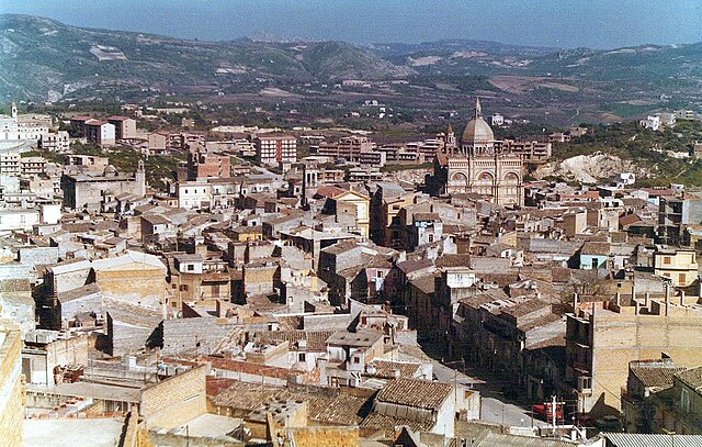
Комитини (Comitini, Comitini)
- коммуна Италии
Comitini, located in the heart of Sicily, offers a unique hiking experience characterized by its beautiful landscapes, historical sites, and natural beauty. Here are some aspects to consider when hiking in this area:
Trails and Routes
-
Natural Paths: Comitini is surrounded by a mix of hilly terrain and valleys, with paths that often lead through olive orchards and vineyards. Some trails may also offer views of the nearby mountains.
-
Cultural Routes: Hiking in Comitini can also include routes that pass through historical and cultural sites, such as old churches and ruins.
-
Nature Reserves: Look for trails that lead into nearby nature reserves or national parks, where you can encounter diverse flora and fauna.
Hiking Conditions
-
Season: The best time to hike in this region is during the spring (April to June) and fall (September to October) when the weather is mild. Summer can be quite hot, making hikes more challenging.
-
Terrain: The terrain can vary from easy walking paths to more challenging rocky areas, so it's important to choose trails that match your experience and fitness level.
Preparation
- Footwear: Good hiking boots are essential due to uneven and sometimes rocky terrain.
- Gear: Bring enough water, snacks, and perhaps a camera for the stunning scenery.
- Local Guidance: If you're unfamiliar with the area, consider hiring a local guide who can provide insights into the best routes and the history of the region.
Safety Tips
- Always let someone know your hiking plans.
- Check weather conditions before heading out, as they can change rapidly.
- Be mindful of wildlife and respect the local environment.
Additional Activities
- Cultural Experiences: After a day of hiking, indulge in the local Sicilian cuisine. Taste local wines and enjoy the hospitality of the townspeople.
Hiking in Comitini can be a rewarding experience, combining physical activity with breathtaking scenery and cultural richness. Always make sure to prepare adequately for a safe and enjoyable hike!
- Страна:

- Почтовый код: 92020
- Телефонный код: 0922
- Код автомобильного номера: AG
- Координаты: 37° 24' 32" N, 13° 38' 38" E


- GPS треки (wikiloc): [Ссылка]
- Высота над уровнем моря: 350 м m
- Площадь: 21.89 кв.км
- Население: 961
- Веб сайт: http://www.comune.comitini.ag.it
- Википедия русская: wiki(ru)
- Википедия английская: wiki(en)
- Википедия национальная: wiki(it)
- Хранилище Wikidata: Wikidata: Q431512
- Катеория в википедии: [Ссылка]
- код Freebase: [/m/0gqg41]
- код GeoNames: Альт: [6540840]
- код VIAF: Альт: [242691706]
- ID отношения в OpenStreetMap: [39237]
- код GND: Альт: [4315118-8]
- код TGN: [1044349]
- код ISTAT: 084016
- кадастровый код Италии: C928
Граничит с регионами:


Арагона
- коммуна Италии
Aragona, located in Sicily, Italy, offers a unique hiking experience with its rich natural landscape, history, and culture. Here are some key points to consider if you plan to hike in the region:...
- Страна:

- Почтовый код: 92021
- Телефонный код: 0922
- Код автомобильного номера: AG
- Координаты: 37° 24' 27" N, 13° 37' 8" E


- GPS треки (wikiloc): [Ссылка]
- Высота над уровнем моря: 400 м m
- Площадь: 74.7 кв.км
- Население: 9409
- Веб сайт: [Ссылка]


Фавара
- коммуна Италии
Favara, a town in Sicily, provides some excellent hiking opportunities, allowing you to explore the beautiful Sicilian landscape and its rich cultural heritage. Here are some key points about hiking in and around Favara:...
- Страна:

- Почтовый код: 92026
- Телефонный код: 0922
- Код автомобильного номера: AG
- Координаты: 37° 19' 7" N, 13° 39' 47" E


- GPS треки (wikiloc): [Ссылка]
- Высота над уровнем моря: 338 м m
- Площадь: 81.88 кв.км
- Население: 32299
- Веб сайт: [Ссылка]


Гротте
- коммуна Италии
Hiking in Grotte, Sicily, offers a unique blend of natural beauty, historical sites, and Mediterranean charm. Grotte is a small town located in the Province of Agrigento, surrounded by stunning landscapes and agricultural land. Here are some highlights and tips for hiking in this area:...
- Страна:

- Почтовый код: 92020
- Телефонный код: 0922
- Код автомобильного номера: AG
- Координаты: 37° 24' 21" N, 13° 42' 4" E


- GPS треки (wikiloc): [Ссылка]
- Высота над уровнем моря: 516 м m
- Площадь: 23.98 кв.км
- Население: 5600
- Веб сайт: [Ссылка]

