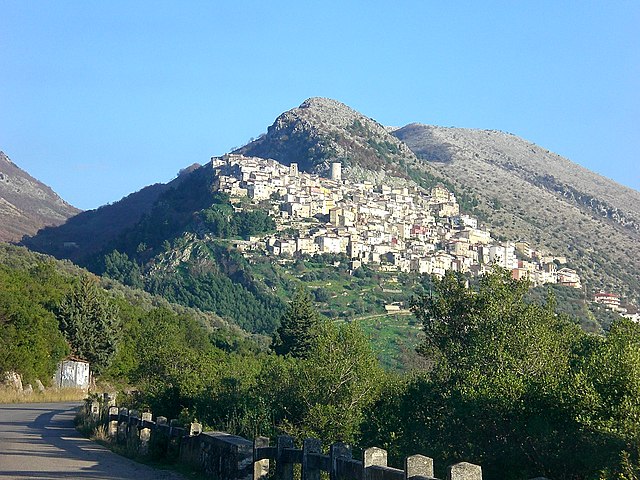
Контроне (Controne, Controne)

- коммуна Италии
 Hiking in Контроне
Controne is a scenic village located in the heart of the Alburni Mountains in the Campania region of Italy. It's known for its beautiful natural landscapes, rich history, and opportunities for outdoor activities, including hiking.
Hiking Opportunities in Controne:
-
Scenic Trails: The surrounding Alburni Mountain range offers a variety of hiking trails suitable for different skill levels. Trails vary from easy walks to challenging hikes, allowing both beginners and experienced hikers to enjoy the area's natural beauty.
-
Natural Beauty: Hikes in this region often feature breathtaking views of rugged mountains, lush forests, and diverse flora and fauna. The area is home to unique geological formations and a range of wildlife, making it a perfect spot for nature lovers and photographers.
-
Historical Sites: Along the trails, you may encounter various historical sites, including ruins, churches, and smaller villages that showcase the region's cultural heritage. Exploring these sites can enrich your hiking experience.
-
Seasonal Hiking: Depending on the time of year, the hiking experience can change dramatically. Spring and early summer offer vibrant wildflowers, while autumn brings beautiful foliage. Winter hikes can provide a completely different atmosphere, though it's essential to check trail conditions during this season.
-
Guided Tours: For those new to hiking or unfamiliar with the area, consider joining a guided tour. Local guides can provide insights into the landscape, history, and ecology of Controne and ensure you have a safe and enjoyable experience.
-
Preparation and Safety: Always make sure to wear appropriate hiking gear, carry enough water, and inform someone about your hiking plans. It's also good practice to check the weather conditions before heading out.
Conclusion
Hiking in Controne offers a fantastic way to experience the beauty of Italy's natural landscapes while immersing yourself in local culture. Whether you’re looking for a peaceful day hike or an adventurous trek, this area has something to offer for everyone.
- Страна:

- Почтовый код: 84020
- Телефонный код: 0828
- Код автомобильного номера: SA
- Координаты: 40° 31' 0" N, 15° 12' 0" E


- GPS треки (wikiloc): [Ссылка]
- Высота над уровнем моря: 210 м m
- Площадь: 7.75 кв.км
- Население: 867
- Веб сайт: http://www.comune.controne.sa.it
- Википедия русская: wiki(ru)
- Википедия английская: wiki(en)
- Википедия национальная: wiki(it)
- Хранилище Wikidata: Wikidata: Q80885
- Катеория в википедии: [Ссылка]
- код Freebase: [/m/0frfjt]
- код GeoNames: Альт: [6540964]
- ID отношения в OpenStreetMap: [40572]
- код ISTAT: 065045
- кадастровый код Италии: C973
Граничит с регионами:


Альтавилла-Силентина
- коммуна Италии
Hiking in Альтавилла-Силентина
Altavilla Silentina, situated in the Campania region of southern Italy, offers a variety of hiking opportunities set against a backdrop of stunning natural beauty. The area features rolling hills, picturesque landscapes, and a rich cultural heritage that enhances the hiking experience. Here are some details about hiking in and around Altavilla Silentina:...
- Страна:
- Почтовый код: 84045
- Телефонный код: 0828
- Код автомобильного номера: SA
- Координаты: 40° 32' 0" N, 15° 8' 0" E
- GPS треки (wikiloc): [Ссылка]
- Высота над уровнем моря: 275 м m
- Площадь: 52.48 кв.км
- Население: 7083
- Веб сайт: [Ссылка]

Кастельчивита
- коммуна Италии
Hiking in Кастельчивита
Hiking in Castelcivita, located in the Campania region of Italy, offers a unique blend of stunning landscapes, historical sites, and natural beauty. The area is known for its rugged terrain and the nearby Castelcivita Caves, which are a fascinating attraction for both hikers and nature enthusiasts....
- Страна:
- Почтовый код: 84020
- Телефонный код: 0828
- Код автомобильного номера: SA
- Координаты: 40° 30' 0" N, 15° 14' 0" E
- GPS треки (wikiloc): [Ссылка]
- Высота над уровнем моря: 487 м m
- Площадь: 57.64 кв.км
- Население: 1653
- Веб сайт: [Ссылка]


Постильоне
- коммуна Италии
Hiking in Постильоне
Postiglione is a municipality located in the Province of Salerno, Italy, nestled in the picturesque region of Campania. Known for its charming landscapes and rural settings, Postiglione offers various hiking opportunities that cater to different skill levels....
- Страна:
- Почтовый код: 84026
- Телефонный код: 0828
- Код автомобильного номера: SA
- Координаты: 40° 34' 0" N, 15° 14' 0" E
- GPS треки (wikiloc): [Ссылка]
- Высота над уровнем моря: 615 м m
- Площадь: 48.24 кв.км
- Население: 2090
- Веб сайт: [Ссылка]