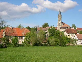
Courcelles (Courcelles)

- коммуна во Франции
 Hiking in Courcelles
Courcelles, located in the Territoire de Belfort department in the Bourgogne-Franche-Comté region of France, offers some beautiful hiking opportunities. This area is known for its picturesque landscapes, lush forests, and proximity to the Vosges mountains, making it ideal for both casual walkers and more experienced hikers.
Hiking Trails
-
Local Paths: You can find several marked paths around Courcelles that lead through the scenic countryside, including forests and meadows. These paths typically vary in difficulty, allowing hikers of all levels to enjoy the area.
-
The Ballon d'Alsace: Not far from Courcelles, the Ballon d'Alsace offers a range of hiking trails with stunning views of the surrounding mountains. It’s a popular destination and offers a variety of routes, from easy walks to more challenging hikes.
-
Nature Reserves: Check for nearby nature reserves that may have dedicated hiking trails. These areas often have well-maintained paths and informative signage about local flora and fauna.
Tips for Hiking in Courcelles
- Wear Appropriate Footwear: Trails can vary from hard-packed dirt to rocky paths, so proper hiking boots are recommended.
- Weather Preparedness: Check the weather forecast before heading out. The region can experience quick weather changes, especially in the mountains.
- Hydration and Snacks: Always bring enough water and snacks, especially for longer hikes.
- Respect Nature: Stay on marked trails and follow Leave No Trace principles to preserve the natural beauty of the area.
Best Time to Hike
The best times for hiking in this region are during the late spring and early autumn months when temperatures are mild, and the scenery is particularly beautiful. Spring offers blooming flowers, while autumn showcases stunning fall colors.
Conclusion
Hiking in Courcelles and its surrounding areas can be a delightful experience, allowing you to connect with nature and explore the diverse landscapes of the Territoire de Belfort. Whether you are looking for a peaceful stroll or a challenging hike, you’ll find plenty of opportunities to enjoy the great outdoors here.
- Страна:

- Почтовый код: 90100
- Координаты: 47° 29' 54" N, 7° 4' 35" E


- GPS треки (wikiloc): [Ссылка]
- Площадь: 5.32 кв.км
- Население: 134
- Википедия английская: wiki(en)
- Википедия национальная: wiki(fr)
- Хранилище Wikidata: Wikidata: Q843348
- Катеория в википедии: [Ссылка]
- код Freebase: [/m/03mh99v]
- код Freebase: [/m/03mh99v]
- код GeoNames: Альт: [6617937]
- код GeoNames: Альт: [6617937]
- номер SIREN: [219000270]
- номер SIREN: [219000270]
- код BNF: [15279968x]
- код BNF: [15279968x]
- код муниципалитета INSEE: 90027
- код муниципалитета INSEE: 90027
Граничит с регионами:

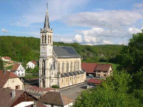
Réchésy
- коммуна во Франции
Hiking in Réchésy
Réchésy is a small locality in the region of France, specifically in the Bourgogne-Franche-Comté area. While it may not be as widely known as some other hiking destinations, it is surrounded by beautiful landscapes and natural features that can appeal to hikers....
- Страна:
- Почтовый код: 90370
- Координаты: 47° 30' 30" N, 7° 6' 47" E
- GPS треки (wikiloc): [Ссылка]
- Площадь: 12.61 кв.км
- Население: 806
- Веб сайт: [Ссылка]


Courtelevant
- коммуна во Франции
Hiking in Courtelevant
Courtelevant, located in the picturesque region of Switzerland, offers numerous opportunities for hiking enthusiasts. The area is known for its stunning landscapes, including rolling hills, dense forests, and sweeping views of the surrounding mountains....
- Страна:
- Почтовый код: 90100
- Координаты: 47° 31' 2" N, 7° 4' 48" E
- GPS треки (wikiloc): [Ссылка]
- Площадь: 5.82 кв.км
- Население: 431
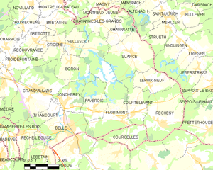
Florimont
- коммуна во Франции
Hiking in Florimont
Florimont, often known for its natural beauty and stunning landscapes, is a great destination for hiking enthusiasts. While specific trails and conditions may vary, here are some general aspects and recommendations for hiking in the area:...
- Страна:
- Почтовый код: 90100
- Координаты: 47° 30' 39" N, 7° 4' 5" E
- GPS треки (wikiloc): [Ссылка]
- Площадь: 18.19 кв.км
- Население: 457