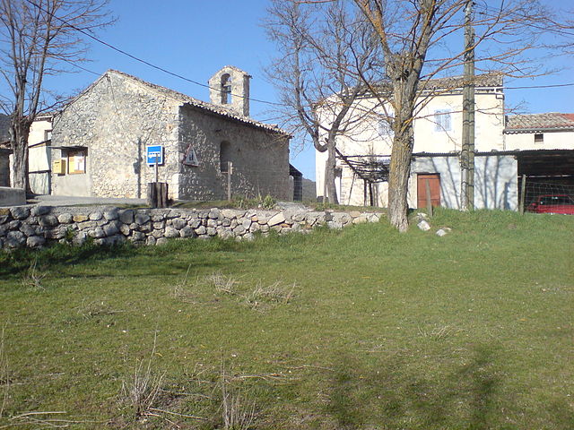
Кюэбри (Cuébris, Cuébris)

- коммуна в департаменте Приморские Альпы, регион Прованс — Альпы — Лазурный Берег, Франция
 Hiking in Кюэбри
Cuébris is a charming village located in the Alpes-Maritimes department in the Provence-Alpes-Côte d'Azur region of France. It offers a variety of hiking opportunities for outdoor enthusiasts, with stunning views, diverse landscapes, and a pleasant Mediterranean climate.
Hiking Routes:
-
Village Trails: There are several short trails around the village that connect to nearby hills and overlooks, providing a great way to explore the local flora and fauna while enjoying panoramic views of the surrounding mountains and valleys.
-
Regional Hiking: Cuébris serves as a good starting point for longer hikes in the nearby valleys and mountains. The area is part of the Mercantour National Park, which offers numerous well-marked trails ranging from easy walks to more challenging hikes.
-
GR Routes: The Grande Randonnée (GR) long-distance hiking paths pass near the region. These trails provide stunning views and a chance to experience the diverse ecosystems of the area.
Tips for Hiking in Cuébris:
- Preparation: Make sure to wear appropriate hiking shoes and bring plenty of water and snacks. Weather in the mountains can change rapidly, so pack layers.
- Maps and Guides: It’s helpful to bring a detailed map of the area or a trail guide, as some routes may not be well-signposted.
- Local Resources: Consider stopping by the local tourist office for updated information on trail conditions, maps, and potential guided tours.
- Respect Nature: Follow Leave No Trace principles to preserve the natural beauty of the area.
Best Time to Hike:
- The best seasons for hiking in and around Cuébris are typically spring (April to June) and early autumn (September to October), when the weather is mild and the trails are less crowded.
Cuébris is a fantastic destination for those looking to experience hiking in a picturesque and tranquil setting. Enjoy your adventure!
- Страна:

- Почтовый код: 06910
- Координаты: 43° 53' 13" N, 7° 1' 14" E


- GPS треки (wikiloc): [Ссылка]
- Площадь: 23.1 кв.км
- Население: 151
- Википедия русская: wiki(ru)
- Википедия английская: wiki(en)
- Википедия национальная: wiki(fr)
- Хранилище Wikidata: Wikidata: Q845153
- Катеория в википедии: [Ссылка]
- код Freebase: [/m/03m4_lm]
- код Freebase: [/m/03m4_lm]
- код GeoNames: Альт: [6446698]
- код GeoNames: Альт: [6446698]
- номер SIREN: [210600524]
- номер SIREN: [210600524]
- код муниципалитета INSEE: 06052
- код муниципалитета INSEE: 06052
Граничит с регионами:
Сен-Пьер
- коммуна во Франции
Hiking in Сен-Пьер
Saint-Pierre, located in the Alpes-de-Haute-Provence region of southeastern France, is a fantastic destination for hiking enthusiasts. The surrounding area offers a variety of trails that cater to different skill levels, from leisurely walks to challenging treks....
- Страна:
- Почтовый код: 06260
- Координаты: 43° 54' 43" N, 6° 55' 28" E
- GPS треки (wikiloc): [Ссылка]
- Площадь: 5.62 кв.км
- Население: 97


Сигаль
- коммуна в департаменте Приморские Альпы, регион Прованс — Альпы — Лазурный Берег, Франция
Hiking in Сигаль
Sigale is a charming village located in the Alpes-Maritimes department of France, in the Provence-Alpes-Côte d'Azur region. It is nestled in the beautiful hills of the Southern French Alps, which makes it an excellent destination for hiking enthusiasts....
- Страна:
- Почтовый код: 06910
- Координаты: 43° 52' 20" N, 6° 57' 52" E
- GPS треки (wikiloc): [Ссылка]
- Площадь: 5.62 кв.км
- Население: 203


Аскро
- коммуна в департаменте Приморские Альпы, регион Прованс — Альпы — Лазурный Берег, Франция
Hiking in Аскро
Ascros, a charming village in the region of Provence-Alpes-Côte d'Azur in southeastern France, offers some beautiful hiking opportunities. Nestled within the picturesque landscape of the French Alps, hiking around Ascros provides a mix of nature, scenic views, and cultural exploration....
- Страна:
- Почтовый код: 06260
- Координаты: 43° 55' 15" N, 7° 0' 49" E
- GPS треки (wikiloc): [Ссылка]
- Площадь: 17.74 кв.км
- Население: 170
- Веб сайт: [Ссылка]

Сент-Антонен
- коммуна в департаменте Приморские Альпы, регион Прованс — Альпы — Лазурный Берег, Франция
Hiking in Сент-Антонен
Saint-Antonin is a picturesque village located in the Alpes-Maritimes department of the Provence-Alpes-Côte d'Azur region in France. This area is known for its stunning landscapes, charming villages, and a variety of outdoor activities, making it an excellent destination for hiking enthusiasts....
- Страна:
- Почтовый код: 06260
- Координаты: 43° 54' 38" N, 6° 58' 48" E
- GPS треки (wikiloc): [Ссылка]
- Площадь: 6.44 кв.км
- Население: 102

Пьерфё
- коммуна в департаменте Приморские Альпы, регион Прованс — Альпы — Лазурный Берег, Франция
Hiking in Пьерфё
Pierrefeu, located in the Var department of the Provence-Alpes-Côte d'Azur region in France, is a beautiful area known for its picturesque landscapes, including hills, vineyards, and Mediterranean flora. Hiking in and around Pierrefeu offers a variety of trails catering to different levels of experience, making it a great destination for both novice and experienced hikers....
- Страна:
- Почтовый код: 06910
- Координаты: 43° 51' 50" N, 7° 5' 31" E
- GPS треки (wikiloc): [Ссылка]
- Площадь: 22.27 кв.км
- Население: 307

Рокестерон
- коммуна в департаменте Приморские Альпы, регион Прованс — Альпы — Лазурный Берег, Франция
Hiking in Рокестерон
Roquesteron is a charming commune located in the Alpes-Maritimes department in southeastern France. It's situated in the foothills of the Alps, making it a wonderful destination for hiking enthusiasts. Here are some details to consider for a hiking adventure in Roquesteron:...
- Страна:
- Почтовый код: 06910
- Координаты: 43° 52' 25" N, 7° 0' 16" E
- GPS треки (wikiloc): [Ссылка]
- Площадь: 6.47 кв.км
- Население: 578

Ла-Пен
- коммуна в департаменте Приморские Альпы, регион Прованс — Альпы — Лазурный Берег, Франция
Hiking in Ла-Пен
La Penne is a picturesque village located in the Var department of France, nestled within the stunning landscape of the Provence region. This area offers a variety of hiking opportunities that cater to different skill levels and preferences. Here are some things to know about hiking in La Penne:...
- Страна:
- Почтовый код: 06260
- Координаты: 43° 55' 41" N, 6° 56' 56" E
- GPS треки (wikiloc): [Ссылка]
- Площадь: 18.08 кв.км
- Население: 263


Салагриффон
- коммуна в департаменте Приморские Альпы, регион Прованс — Альпы — Лазурный Берег, Франция
Hiking in Салагриффон
Sallagriffon is not widely recognized as a well-known hiking destination. However, if you meant a specific area or region, I’d be happy to provide information about hiking in that location!...
- Страна:
- Почтовый код: 06910
- Координаты: 43° 53' 0" N, 6° 54' 26" E
- GPS треки (wikiloc): [Ссылка]
- Высота над уровнем моря: 720 м m
- Площадь: 9.59 кв.км
- Население: 45