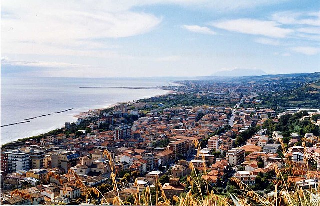
Купра-Мариттима (Cupra Marittima, Cupra Marittima)
.svg)
- коммуна Италии
 Hiking in Купра-Мариттима
Cupra Marittima is a charming town located along the Adriatic coast in the Marche region of Italy. While it's more commonly known for its beautiful beaches and historical sites, the surrounding countryside offers some wonderful hiking opportunities.
Hiking Locations and Trails
-
The Abbadia di San Benedetto: Just a short distance from Cupra Marittima, this ancient abbey is surrounded by picturesque landscapes. There are trails that allow you to explore the hilly terrain and enjoy sweeping views of the Adriatic Sea.
-
Sentina Nature Reserve: A little further south, this protected area offers trails through diverse ecosystems, including sand dunes, wetlands, and coastal areas. It's a fantastic spot for both hiking and bird watching.
-
Mount Ascensione: For a more challenging hike, you can head inland towards this mountain. There are various trails leading to the summit that can provide stunning views of the region and the Adriatic coast.
-
Via dei Colori: This scenic trail runs through the hills and vineyards near Cupra Marittima, offering a lovely way to experience the local flora and fauna. It’s an easier hike, perfect for families.
Tips for Hiking in Cupra Marittima
-
Best Time to Hike: Spring (April to June) and Fall (September to October) are ideal times for hiking as temperatures are mild, and the landscape is particularly beautiful with blooming wildflowers or autumn colors.
-
Preparation: Always check the trail conditions and bring plenty of water, as well as snacks. A good pair of hiking shoes is essential for rocky or uneven paths.
-
Local Guidance: Consider hiring a local guide or joining a hiking group to enhance your experience. They can provide insights about the area’s history and ecology.
-
Cultural Sites: Combine your hiking with visits to local attractions, such as the historical center of Cupra Marittima, where you can explore ancient ruins and enjoy local cuisine.
-
Respect the Environment: Stay on marked trails, and take all of your trash with you to preserve the natural beauty of the area.
Hiking in Cupra Marittima offers a wonderful blend of nature, culture, and stunning views, making it an excellent destination for both novice and experienced hikers. Enjoy your adventure!
- Страна:

- Почтовый код: 63064
- Телефонный код: 0735
- Код автомобильного номера: AP
- Координаты: 43° 1' 30" N, 13° 51' 32" E


- GPS треки (wikiloc): [Ссылка]
- Высота над уровнем моря: 4 м m
- Площадь: 17.34 кв.км
- Население: 5358
- Веб сайт: http://www.comune.cupra-marittima.ap.it/
- Википедия русская: wiki(ru)
- Википедия английская: wiki(en)
- Википедия национальная: wiki(it)
- Хранилище Wikidata: Wikidata: Q56055
- Галерея изображений в википедии: [Ссылка]
- Катеория в википедии: [Ссылка]
- код Freebase: [/m/0gl7vb]
- код GeoNames: Альт: [6541873]
- код VIAF: Альт: [140702691]
- ID отношения в OpenStreetMap: [42277]
- код LCNAF: Альт: [n78092612]
- WOEID: [714924]
- UN/LOCODE: [ITCPM]
- код Цифрового атласа Римской империи: [22907]
- Google Maps Customer ID: [3867887712871044671]
- код ISTAT: 044017
- кадастровый код Италии: D210
Граничит с регионами:

Гроттаммаре
- коммуна Италии
Hiking in Гроттаммаре
Grottammare is a charming coastal town located along the Adriatic Sea in the Marche region of Italy. While it’s primarily known for its beautiful beaches and vibrant promenade, there are opportunities for hiking and exploring the surrounding landscapes, particularly in the nearby hills and natural reserves....
- Страна:
- Почтовый код: 63066
- Телефонный код: 0735
- Код автомобильного номера: AP
- Координаты: 42° 59' 21" N, 13° 52' 5" E
- GPS треки (wikiloc): [Ссылка]
- Высота над уровнем моря: 4 м m
- Площадь: 17.66 кв.км
- Население: 15286
- Веб сайт: [Ссылка]
Массиньяно
- коммуна Италии
Hiking in Массиньяно
Massignano is a charming village located in the Marche region of Italy, known for its scenic landscapes and hiking opportunities. The area is characterized by rolling hills, vineyards, olive groves, and a beautiful coastline along the Adriatic Sea. Here are some key features and tips for hiking in and around Massignano:...
- Страна:
- Почтовый код: 63061
- Телефонный код: 0735
- Код автомобильного номера: AP
- Координаты: 43° 3' 3" N, 13° 47' 50" E
- GPS треки (wikiloc): [Ссылка]
- Высота над уровнем моря: 255 м m
- Площадь: 16.3 кв.км
- Население: 1640
- Веб сайт: [Ссылка]
Рипатрансоне
- коммуна Италии
Hiking in Рипатрансоне
Ripatransone, located in the Marche region of Italy, is a charming hilltop town known for its stunning landscapes, historic architecture, and scenic hiking opportunities. Here are some highlights of hiking in and around Ripatransone:...
- Страна:
- Почтовый код: 63065
- Телефонный код: 0735
- Код автомобильного номера: AP
- Координаты: 43° 0' 1" N, 13° 45' 45" E
- GPS треки (wikiloc): [Ссылка]
- Высота над уровнем моря: 494 м m
- Площадь: 74.28 кв.км
- Население: 4232
- Веб сайт: [Ссылка]