Дюрлауйнген (Dürrlauingen, Dürrlauingen)

 Hiking in Дюрлауйнген
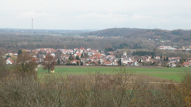
Dürrlauingen is a small village located in Germany, surrounded by beautiful natural scenery that is ideal for hiking enthusiasts. Though it may not be as widely known as some other hiking locations, it offers a range of trails suitable for different skill levels.
Hiking Highlights in Dürrlauingen:
-
Scenic Trails: The region around Dürrlauingen features a mix of forests, fields, and scenic views of the surrounding countryside. The trails often allow for the exploration of local flora and fauna.
-
Accessibility: Being a small village, the hiking trails are generally accessible, and the area is not overly crowded, allowing for a peaceful hiking experience.
-
Regional Natura 2000 Sites: Some trails may lead through protected areas that are part of the Natura 2000 network, which aims to preserve biodiversity and natural habitats. This can provide opportunities for wildlife spotting and appreciating diverse ecosystems.
-
Local Culture: Hiking in the area can also provide you with a chance to experience local culture. You might come across traditional farms and small villages that showcase the charm of rural Bavaria.
-
Difficulty Levels: The hiking options vary from easy walks suitable for families and beginners to more challenging routes for experienced hikers. Always check trail markers and maps to find the best routes for your group.
-
Weather Considerations: As with any hiking excursions, be mindful of the weather conditions. The best times for hiking in the region are typically spring and fall, when temperatures are moderate and the scenery is particularly appealing.
-
Equipment: Make sure to wear appropriate footwear and carry enough water and snacks, especially if you plan to hike longer trails. If you're venturing into more rural or less marked paths, having a map or GPS can be beneficial.
-
Local Hiking Groups: Check if there are any local hiking clubs or groups that organize hikes in and around Dürrlauingen. Joining a group can provide you with guided experiences and opportunities to meet fellow hiking enthusiasts.
As you plan your trip to Dürrlauingen, it's a good idea to research specific trails and gather any necessary maps. Enjoy exploring the serene beauty of this picturesque part of Germany!
- Страна:

- Почтовый код: 89350
- Телефонный код: 08222
- Код автомобильного номера: GZ
- Координаты: 48° 28' 0" N, 10° 26' 0" E


- GPS треки (wikiloc): [Ссылка]
- Высота над уровнем моря: 503 м m
- Площадь: 12.34 кв.км
- Население: 1862
- Веб сайт: http://www.duerrlauingen.de/
- Википедия русская: wiki(ru)
- Википедия английская: wiki(en)
- Википедия национальная: wiki(de)
- Хранилище Wikidata: Wikidata: Q266726
- Катеория в википедии: [Ссылка]
- код Freebase: [/m/02q3bdp]
- код GeoNames: Альт: [2934317]
- код VIAF: Альт: [243850274]
- ID отношения в OpenStreetMap: [964238]
- код GND: Альт: [4470857-9]
- WOEID: [646061]
- код Historical Gazetteer: [DURGE1JN58FL]
- Bavarikon ID: [ODB_A00000660]
- идентификатор муниципалитетов в Германии: 09774127
Граничит с регионами:


Бургау
Hiking in Бургау
Burgau, a charming coastal town in the Algarve region of Portugal, offers beautiful landscapes perfect for hiking enthusiasts. The town is nestled along the stunning cliffs of the Atlantic and is surrounded by picturesque scenery, including beaches, rural areas, and natural parks. Here are some highlights for hiking in and around Burgau:...
- Страна:
- Почтовый код: 89331
- Телефонный код: 08222
- Код автомобильного номера: GZ
- Координаты: 48° 25' 54" N, 10° 24' 36" E
- GPS треки (wikiloc): [Ссылка]
- Высота над уровнем моря: 454 м m
- Площадь: 25.92 кв.км
- Население: 8111
- Веб сайт: [Ссылка]

Оффинген
Hiking in Оффинген
Offingen is a small town located in Bavaria, Germany, known for its picturesque landscapes and charming surroundings that make it suitable for hiking enthusiasts. Here are some key points about hiking in and around Offingen:...
- Страна:
- Почтовый код: 89362
- Телефонный код: 08224
- Код автомобильного номера: GZ
- Координаты: 48° 28' 0" N, 10° 22' 0" E
- GPS треки (wikiloc): [Ссылка]
- Высота над уровнем моря: 440 м m
- Площадь: 14.93 кв.км
- Население: 3330
- Веб сайт: [Ссылка]