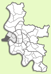
Heerdt (Heerdt)
Düsseldorf-Heerdt, a district located along the left bank of the Rhine River in Düsseldorf, has a vibrant landscape suitable for recreational activities, including hiking. While Heerdt itself may not have extensive hiking trails compared to more rural areas, there are several options for enjoying the outdoors.
Local Parks and Trails
-
Rheinpark: This park along the Rhine offers scenic paths perfect for walking and light hiking. You can enjoy views of the river and the Düsseldorf skyline. The park has various green spaces, making it ideal for leisurely walks.
-
The Rhine Promenade: Along the river, there are pathways that extend into adjacent areas such as Oberkassel and further along the Rhine. You can take a long walk or even bike ride while enjoying views of the Rhine and the city.
-
Heerdt Forest: Although smaller than major forests, any local green spaces can provide options for short hikes and nature walks.
Nearby Hiking Opportunities
If you're willing to venture a bit further, there are several nature reserves and hiking trails accessible within a short drive or public transport ride:
- The Grafenberg Forest: Located a bit southeast of Heerdt, this forest offers a larger network of trails and is a great spot for hiking with more nature to explore.
- Küthener Weg: Just outside of the city, this nature area allows for a longer hiking experience with local flora and fauna.
Tips for Hiking in Düsseldorf-Heerdt
- Check the Weather: Be aware of the weather conditions, as they can change, and make sure to dress appropriately.
- Local Maps: Use local trail maps or a hiking app to stay oriented, especially if you choose to explore paths beyond Heerdt.
- Stay Hydrated: Carry enough water, especially if you're planning longer hikes or walks.
- Public Transport: Familiarize yourself with local public transport options if you want to access more extensive hiking areas outside of Heerdt.
While Heerdt may not be a hiking destination in the traditional sense, it does offer a pleasant blend of urban and natural environments for enjoyable walks and easy hikes along the scenic Rhine.
- Страна:

- Координаты: 51° 13' 42" N, 6° 42' 57" E


- GPS треки (wikiloc): [Ссылка]
- Википедия английская: wiki(en)
- Википедия национальная: wiki(de)
- Хранилище Wikidata: Wikidata: Q1551074
- Катеория в википедии: [Ссылка]
- код GeoNames: Альт: [2908312]
- код VIAF: Альт: [245662835]
- код GND: Альт: [4091332-6]
- идентификатор местоположения ArchINFORM: [43649]

