
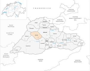
Делемон (Delémont, Delsberg)

 Hiking in Делемон
Delémont, the capital of the Jura canton in Switzerland, offers a variety of hiking opportunities that cater to different skill levels and preferences. The surrounding landscape is characterized by rolling hills, dense forests, and picturesque views of the Jura Mountains. Here are some highlights of hiking in and around Delémont:
Trails and Routes
-
Sentier du Doubs: This scenic trail follows the banks of the Doubs River and features beautiful views of the water and the surrounding nature. It's suitable for families and those looking for a leisurely hike.
-
Jura Crest Trail: Known as "Jura-Höhenweg," this long-distance trail runs through the Jura Mountains, offering hikers stunning panoramic views and a chance to experience the diverse flora and fauna of the region. Portions of this trail pass near Delémont.
-
Local Circuit Trails: There are several short and medium-length circuits around Delémont suitable for all skill levels. These trails often provide well-marked paths with various points of interest, including historical landmarks and viewpoints.
Difficulty Levels
- Easy: Many flat trails and shorter hikes around the city are suitable for beginners or families with children.
- Moderate: Hills and slightly more challenging terrains provide a good workout while still being accessible to the average hiker.
- Difficult: More challenging trails with steep ascents may require proper hiking gear and experience.
Best Time to Hike
- The optimal time for hiking in Delémont is during spring (April to June) and early autumn (September to October) when the weather is mild, and the landscapes are lush. Summer can also be a great time, though it may be warmer, and some higher trails could be snow-covered until late spring.
Safety and Preparation
- Always check the weather conditions before heading out, as they can change rapidly in the mountains.
- Make sure to wear appropriate footwear and bring enough water and snacks.
- It’s wise to have a map or GPS device since some trails may not be marked clearly.
Local Information
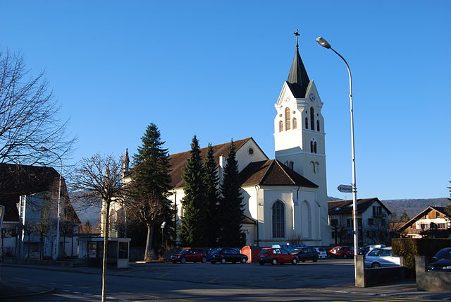
- Delémont has a charming old town, with opportunities for dining and relaxing after a long hike.
- Local tourist information centers can provide maps, trail conditions, and recommendations.
With its beautiful landscapes and variety of trails, hiking in Delémont provides a delightful experience for nature lovers and outdoor enthusiasts.
- Страна:

- Почтовый код: 2800
- Телефонный код: 032
- Код автомобильного номера: JU
- Координаты: 47° 21' 55" N, 7° 20' 50" E


- GPS треки (wikiloc): [Ссылка]
- Высота над уровнем моря: 435 м m
- Площадь: 22 кв.км
- Население: 12625
- Веб сайт: http://www.delemont.ch
- Википедия русская: wiki(ru)
- Википедия английская: wiki(en)
- Википедия национальная: wiki(de)
- Хранилище Wikidata: Wikidata: Q63896
- Катеория в википедии: [Ссылка]
- код Freebase: [/m/0293gk]
- код GeoNames: Альт: [2661035]
- код BNF: [119866447]
- код VIAF: Альт: [163177235]
- ID отношения в OpenStreetMap: [1685596]
- код GND: Альт: [4266795-1]
- идентификатор местоположения ArchINFORM: [7166]
- код LCNAF: Альт: [n82075245]
- место в MusicBrainz: [e11479a4-11fe-4e18-a734-4fb6edcd4663]
- код в энциклопедии «Британника онлайн»: [place/Delemont]
- идентификатор HDS: [2938]
- EMLO location ID: [3b23e580-52d5-42f6-89f2-8e20a2b7c3b3]
- код швейцарского муниципалитета: [6711]
Граничит с регионами:
Courtételle
Hiking in Courtételle
Courtételle is a charming municipality located in the canton of Jura, Switzerland, known for its beautiful landscapes and outdoor activities, including hiking. The region is characterized by rolling hills, forested areas, and picturesque views, making it an excellent destination for hikers of varying skill levels....
- Страна:
- Почтовый код: 2852
- Телефонный код: 032
- Код автомобильного номера: JU
- Координаты: 47° 19' 51" N, 7° 19' 4" E
- GPS треки (wikiloc): [Ссылка]
- Высота над уровнем моря: 488 м m
- Площадь: 13.56 кв.км
- Население: 2582
- Веб сайт: [Ссылка]


Mettembert
Hiking in Mettembert
As of my last update, I don't have specific information on "Mettembert." However, if you're referring to a hiking destination, it could potentially be a lesser-known or regional location. To provide useful hiking advice, I can offer general tips for hiking in any area....
- Страна:
- Почтовый код: 2806
- Телефонный код: 032
- Код автомобильного номера: JU
- Координаты: 47° 24' 0" N, 7° 19' 0" E
- GPS треки (wikiloc): [Ссылка]
- Высота над уровнем моря: 660 м m
- Площадь: 2.41 кв.км
- Население: 105


Rossemaison
Hiking in Rossemaison
Rossemaison is a charming village located in the Jura region of Switzerland, known for its picturesque landscapes and opportunities for outdoor activities, including hiking. The Jura mountains offer a variety of trails suitable for different skill levels, making it a great destination for both beginners and experienced hikers....
- Страна:
- Почтовый код: 2842
- Телефонный код: 032
- Код автомобильного номера: JU
- Координаты: 47° 21' 0" N, 7° 21' 0" E
- GPS треки (wikiloc): [Ссылка]
- Высота над уровнем моря: 455 м m
- Площадь: 1.98 кв.км
- Население: 641
- Веб сайт: [Ссылка]

Develier
Hiking in Develier
Develier is a beautiful location in the Jura region of Switzerland, known for its stunning landscapes, rich biodiversity, and numerous hiking trails. While it may not be as well-known as some prominent hiking destinations, it offers a wonderful experience for hikers of all skill levels....
- Страна:
- Почтовый код: 2802
- Телефонный код: 032
- Код автомобильного номера: JU
- Координаты: 47° 21' 0" N, 7° 17' 0" E
- GPS треки (wikiloc): [Ссылка]
- Высота над уровнем моря: 477 м m
- Площадь: 12.42 кв.км
- Население: 1385
- Веб сайт: [Ссылка]

Коуррендлин
- город в Швейцарии
Hiking in Коуррендлин
Courrendlin is a charming village located in the Jura region of Switzerland, providing a beautiful backdrop for hiking enthusiasts. The area is characterized by rolling hills, lush forests, and stunning views of the surrounding landscape. Here are some highlights about hiking in Courrendlin:...
- Страна:
- Почтовый код: 2830
- Телефонный код: 032
- Код автомобильного номера: JU
- Координаты: 47° 20' 0" N, 7° 22' 0" E
- GPS треки (wikiloc): [Ссылка]
- Высота над уровнем моря: 441 м m
- Площадь: 11.07 кв.км
- Население: 2995
- Веб сайт: [Ссылка]


Bourrignon
Hiking in Bourrignon
Bourrignon is a beautiful village located in the Jura region of Switzerland, known for its stunning natural landscapes and opportunities for outdoor activities such as hiking. The area features a mix of rolling hills, forests, and scenic views, making it an enjoyable destination for hikers of all levels....
- Страна:
- Телефонный код: 032
- Код автомобильного номера: JU
- Координаты: 47° 24' 0" N, 7° 15' 0" E
- GPS треки (wikiloc): [Ссылка]
- Высота над уровнем моря: 770 м m
- Площадь: 13.56 кв.км
- Население: 261
- Веб сайт: [Ссылка]

Courroux
Hiking in Courroux
Courroux, located in the Jura region of Switzerland, offers a variety of hiking opportunities that showcase the natural beauty of the area. Here are some highlights you can expect when hiking in Courroux:...
- Страна:
- Почтовый код: 2822
- Телефонный код: 032
- Код автомобильного номера: JU
- Координаты: 47° 22' 9" N, 7° 23' 35" E
- GPS треки (wikiloc): [Ссылка]
- Высота над уровнем моря: 486 м m
- Площадь: 19.21 кв.км
- Население: 3265
- Веб сайт: [Ссылка]


Soyhières
Hiking in Soyhières
Soyhières is a charming village located in the Jura region of Switzerland, known for its stunning natural landscapes and hiking opportunities. Here are some key points to consider when hiking in Soyhières:...
- Страна:
- Почтовый код: 2805
- Телефонный код: 032
- Код автомобильного номера: JU
- Координаты: 47° 24' 0" N, 7° 22' 0" E
- GPS треки (wikiloc): [Ссылка]
- Высота над уровнем моря: 405 м m
- Площадь: 7.55 кв.км
- Население: 448
- Веб сайт: [Ссылка]