
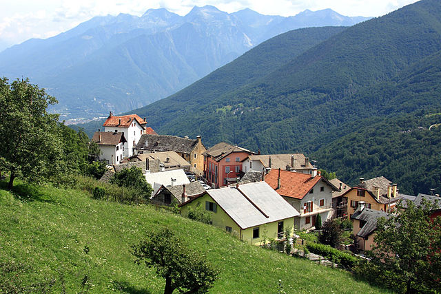
Домодоссола (Domodossola, Domodossola)
- коммуна Италии
 Hiking in Домодоссола
Domodossola, located in the Ossola Valley in northern Italy, is surrounded by stunning natural landscapes, making it a fantastic destination for hiking enthusiasts. Here are some key points about hiking in the area:
Trails and Routes
-
Val Grande National Park: This park, near Domodossola, offers several trails ranging from easy to challenging. It’s known for its rugged wilderness, deep valleys, and beautiful landscapes. The park is one of the largest wilderness areas in Italy and is home to various wildlife.
-
Mottarone: Accessible from Domodossola, Mottarone's trails provide breathtaking vistas of the surrounding mountains and lakes. The hike to the summit rewards you with panoramic views of Lake Maggiore and the surrounding peaks.
-
The “Cammino di Oropa”: This is a scenic pilgrimage route that takes you through beautiful valleys and quaint villages. The route typically connects Domodossola to the Sanctuary of Oropa.
-
Fort San Carlo: This can be a more historical hike where you can explore old military fortifications while enjoying views of the valley.
Seasonal Considerations
- Spring and Fall: The ideal times for hiking in the Domodossola area are during the spring and fall, when temperatures are milder, and the landscapes are particularly picturesque thanks to blooming wildflowers or autumn foliage.
- Summer: Summer can attract more hikers, so expect busier trails. However, the higher elevation hikes provide a respite from the heat.
- Winter: While many trails may be snow-covered and challenging, there are opportunities for winter sports and snowshoeing in the mountainous areas.
Preparation and Gear
- Maps and Guides: It's beneficial to have a local map or hiking app to navigate the trails, as well as information about trail difficulty levels.
- Footwear: Good hiking boots are essential, considering some trails may be rugged.
- Weather Gear: Always check local weather conditions before heading out, as weather can change rapidly in the mountains.
Local Tips
- Accommodations: Domodossola has various options for overnight stays, from hotels to hostels, making it a great base for multi-day treks.
- Cuisine: After a day of hiking, enjoy local Osso Buco or polenta at regional restaurants to refuel.
- Transport: Domodossola is well-connected by train, making it easy to access other trailheads or even to make day trips to nearby hiking regions.
Whether you’re a seasoned hiker or a beginner, Domodossola offers a wonderful array of hiking opportunities amidst the beauty of the Italian Alps. Always ensure to hike safely, respect nature, and enjoy your adventure!
- Страна:

- Почтовый код: 28845; CH-3907
- Телефонный код: 0324
- Код автомобильного номера: VB
- Координаты: 46° 6' 0" N, 8° 18' 0" E


- GPS треки (wikiloc): [Ссылка]
- Высота над уровнем моря: 272 м m
- Площадь: 36.89 кв.км
- Население: 18237
- Веб сайт: http://www.comune.domodossola.vb.it
- Википедия русская: wiki(ru)
- Википедия английская: wiki(en)
- Википедия национальная: wiki(it)
- Хранилище Wikidata: Wikidata: Q23325
- Галерея изображений в википедии: [Ссылка]
- Катеория в википедии: [Ссылка]
- код Freebase: [/m/01w1c6]
- код GeoNames: Альт: [6539444]
- код BNF: [144912122]
- код VIAF: Альт: [135156797]
- ID отношения в OpenStreetMap: [46855]
- код GND: Альт: [4231022-2]
- идентификатор местоположения ArchINFORM: [7163]
- код LCNAF: Альт: [no93004996]
- место в MusicBrainz: [d6601432-53b2-439f-8967-c8389e4a27f8]
- UN/LOCODE: [ITDOM]
- идентификатор HDS: [7050]
- код Цифрового атласа Римской империи: [18707]
- код ISTAT: 103028
- кадастровый код Италии: D332
Граничит с регионами:
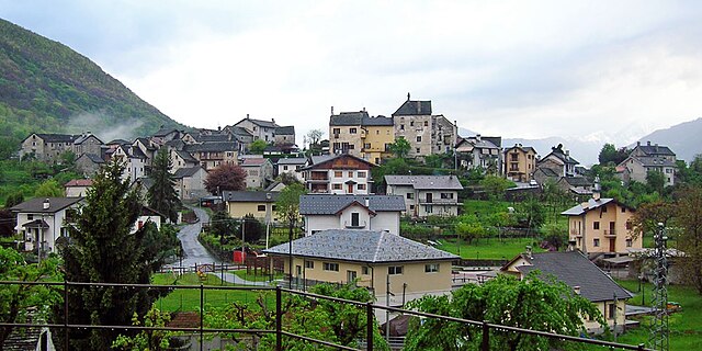
Беура-Кардецца
- коммуна Италии
Hiking in Беура-Кардецца
Beura-Cardezza is a picturesque area located in the Piedmont region of Italy, nestled at the foot of the Alps. It offers diverse hiking opportunities, characterized by stunning landscapes, rich flora and fauna, and a blend of cultural heritage. Here are some key aspects to consider when planning a hiking trip in Beura-Cardezza:...
- Страна:
- Почтовый код: 28851
- Телефонный код: 0324
- Код автомобильного номера: VB
- Координаты: 46° 5' 0" N, 8° 18' 0" E
- GPS треки (wikiloc): [Ссылка]
- Высота над уровнем моря: 257 м m
- Площадь: 28.55 кв.км
- Население: 1473
- Веб сайт: [Ссылка]
Боньянко
- коммуна Италии
Hiking in Боньянко
Bognanco is a charming village located in the Ossola Valley in the Piedmont region of Italy, known for its beautiful natural landscapes and rich cultural heritage. Hiking in and around Bognanco can be a wonderful experience, thanks to its scenic trails, lush forests, and stunning mountain views....
- Страна:
- Почтовый код: 28042
- Телефонный код: 0324
- Код автомобильного номера: VB
- Координаты: 46° 7' 34" N, 8° 12' 0" E
- GPS треки (wikiloc): [Ссылка]
- Высота над уровнем моря: 980 м m
- Площадь: 58 кв.км
- Население: 200
- Веб сайт: [Ссылка]

Креволадоссола
- коммуна Италии
Hiking in Креволадоссола
Crevoladossola is a charming town located in the Piedmont region of northern Italy, nestled at the entrance to the Val Vigezzo, surrounded by stunning Alpine scenery. The area offers a variety of hiking opportunities that cater to different skill levels, from leisurely walks to more challenging treks....
- Страна:
- Почтовый код: 28865
- Телефонный код: 0324
- Код автомобильного номера: VB
- Координаты: 46° 10' 0" N, 8° 18' 0" E
- GPS треки (wikiloc): [Ссылка]
- Высота над уровнем моря: 375 м m
- Площадь: 39.87 кв.км
- Население: 4600
- Веб сайт: [Ссылка]

Мазера
- коммуна Италии
Hiking in Мазера
Masera is a charming commune located in the province of Verbano-Cusio-Ossola in the Piedmont region of northern Italy. It is nestled in the scenic Val D’Ossola, an area known for its stunning natural landscapes, lush valleys, and impressive mountain ranges, making it a fantastic destination for hiking enthusiasts....
- Страна:
- Почтовый код: 28855
- Телефонный код: 0324
- Код автомобильного номера: VB
- Координаты: 46° 10' 0" N, 8° 18' 0" E
- GPS треки (wikiloc): [Ссылка]
- Высота над уровнем моря: 297 м m
- Площадь: 20.35 кв.км
- Население: 1483
- Веб сайт: [Ссылка]
Монтескено
- коммуна Италии
Hiking in Монтескено
Montescheno is a picturesque village located in the Piedmont region of northern Italy, nestled in the Ossola Valley. The area is known for its stunning landscapes, rich biodiversity, and charming old-world architecture, making it a great destination for hiking enthusiasts....
- Страна:
- Почтовый код: 28843
- Телефонный код: 0324
- Код автомобильного номера: VB
- Координаты: 46° 4' 0" N, 8° 14' 0" E
- GPS треки (wikiloc): [Ссылка]
- Высота над уровнем моря: 512 м m
- Площадь: 22.17 кв.км
- Население: 398
- Веб сайт: [Ссылка]
Траскуера
- коммуна Италии
Hiking in Траскуера
Trasquera is a charming village located in the Piedmont region of Italy, specifically in the Val d'Ossola. It's surrounded by stunning natural landscapes, making it a great destination for hiking enthusiasts. Here are some key aspects of hiking in Trasquera:...
- Страна:
- Почтовый код: 28868
- Телефонный код: 0324
- Код автомобильного номера: VB
- Координаты: 46° 8' 0" N, 8° 12' 0" E
- GPS треки (wikiloc): [Ссылка]
- Высота над уровнем моря: 1100 м m
- Площадь: 39.6 кв.км
- Население: 178
- Веб сайт: [Ссылка]
Тронтано
- коммуна Италии
Hiking in Тронтано
Trontano is a small village located in the Val Vigezzo region of Italy, known for its stunning landscapes and hiking opportunities. It’s nestled in the Piedmont region and is surrounded by the beautiful mountains of the Lepontine Alps. Here are some highlights of hiking in and around Trontano:...
- Страна:
- Почтовый код: 28859
- Телефонный код: 0324
- Код автомобильного номера: VB
- Координаты: 46° 5' 0" N, 8° 18' 0" E
- GPS треки (wikiloc): [Ссылка]
- Высота над уровнем моря: 520 м m
- Площадь: 56.74 кв.км
- Население: 1652
- Веб сайт: [Ссылка]

Вилладоссола
- коммуна Италии
Hiking in Вилладоссола
Villadossola, located in the Piedmont region of northern Italy, is an excellent base for hiking enthusiasts. Nestled in the Val d'Ossola, it offers a variety of trails that cater to different skill levels, from beginners to experienced hikers. The stunning natural scenery includes lush forests, alpine meadows, and impressive mountain views, particularly of the nearby Alps....
- Страна:
- Почтовый код: 28844
- Телефонный код: 0324
- Код автомобильного номера: VB
- Координаты: 46° 4' 25" N, 8° 16' 1" E
- GPS треки (wikiloc): [Ссылка]
- Высота над уровнем моря: 257 м m
- Площадь: 18.73 кв.км
- Население: 6617
- Веб сайт: [Ссылка]