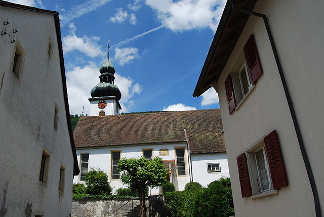
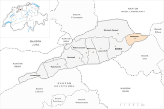
Эгеркинген (Egerkingen, Egerkingen)

 Hiking in Эгеркинген
Egerkingen, located in the Canton of Solothurn in Switzerland, is a great destination for hiking enthusiasts. Nestled amidst picturesque countryside and rolling hills, the area offers a variety of trails that cater to different skill levels.
Hiking Trails
-
Egerkingen to Matzendorf: This is a popular route that provides stunning views of the surrounding landscape. The trail is relatively moderate, making it suitable for families and casual hikers.
-
Kaiseraugst to Egerkingen Loop: This loop combines scenic views with the chance to explore nearby towns. The trail is well-marked and offers a mix of forest paths and open fields.
-
Egerkingen to the Aargau Jura Park: This trail takes you through beautiful natural areas, showcasing the flora and fauna of the region. The park itself is well worth a visit.
Important Considerations
- Weather: Always check the weather before you head out. Conditions can change rapidly in the Alps.
- Gear: Wear appropriate hiking boots, and bring along enough water and snacks. Map or GPS is a good idea since not all trails may have cell service.
- Trail Markings: The trails around Egerkingen are generally well-marked; however, take care to stay on designated paths.
Scenic Points
Egerkingen is known for its beautiful panoramas, particularly from higher vantage points. The views of the Jura mountains and the Aare valley can be breathtaking.
Wildlife
Keep an eye out for local wildlife, including birds and small mammals. The region is home to a variety of species due to its diverse habitats.
Accessibility
Egerkingen is accessible by public transport, with regular train services connecting it to major Swiss cities. This makes it an easy spot for day hikes.
Hiking in Egerkingen provides a wonderful opportunity to experience the stunning natural beauty of Switzerland. Whether you are looking for a leisurely walk or a more challenging trek, there are plenty of options to savor the great outdoors.
- Страна:

- Почтовый код: 4622
- Телефонный код: 062
- Код автомобильного номера: SO
- Координаты: 47° 19' 34" N, 7° 47' 47" E


- GPS треки (wikiloc): [Ссылка]
- Высота над уровнем моря: 516 м m
- Площадь: 6.93 кв.км
- Население: 3520
- Веб сайт: http://www.egerkingen.ch
- Википедия русская: wiki(ru)
- Википедия английская: wiki(en)
- Википедия национальная: wiki(de)
- Хранилище Wikidata: Wikidata: Q64275
- Катеория в википедии: [Ссылка]
- код Freebase: [/m/02t7b8]
- код GeoNames: Альт: [7285701]
- код VIAF: Альт: [134349962]
- ID отношения в OpenStreetMap: [1683498]
- идентификатор HDS: [1057]
- код швейцарского муниципалитета: [2401]
Граничит с регионами:


Лангенбрук
Hiking in Лангенбрук
Langenbruck, located in the beautiful region of the Swiss Jura Mountains, offers a range of hiking opportunities for all levels of experience. The scenic landscapes feature rolling hills, lush forests, and panoramic views of the surrounding mountains. Here are some key points to keep in mind when planning a hike in Langenbruck:...
- Страна:
- Почтовый код: 4438
- Телефонный код: 062
- Код автомобильного номера: BL
- Координаты: 47° 21' 29" N, 7° 46' 15" E
- GPS треки (wikiloc): [Ссылка]
- Высота над уровнем моря: 758 м m
- Площадь: 15.69 кв.км
- Население: 957
- Веб сайт: [Ссылка]


Гунцген
Hiking in Гунцген
Gunzgen, located in the canton of Aargau, Switzerland, is a charming area for hiking enthusiasts. The region is characterized by picturesque landscapes, including rolling hills, dense forests, and scenic views of the Swiss countryside....
- Страна:
- Почтовый код: 4617
- Телефонный код: 062
- Код автомобильного номера: SO
- Координаты: 47° 18' 46" N, 7° 50' 7" E
- GPS треки (wikiloc): [Ссылка]
- Высота над уровнем моря: 438 м m
- Площадь: 3.91 кв.км
- Население: 1651
- Веб сайт: [Ссылка]
Хольдербанк
- населённый пункт в кантоне Золотурн, Швейцария
Hiking in Хольдербанк
Holderbank, located in the Solothurn canton of Switzerland, is a fantastic destination for hiking enthusiasts. The area is known for its scenic landscapes, diverse trails, and stunning views of the surrounding Jura mountains. Here are some highlights and tips for hiking in Holderbank:...
- Страна:
- Почтовый код: 4718
- Телефонный код: 062
- Код автомобильного номера: SO
- Координаты: 47° 19' 59" N, 7° 45' 5" E
- GPS треки (wikiloc): [Ссылка]
- Высота над уровнем моря: 654 м m
- Площадь: 7.9 кв.км
- Население: 693
- Веб сайт: [Ссылка]


Херкинген
Hiking in Херкинген
Härkingen is a small municipality in the canton of Solothurn, Switzerland, and while it may not be as widely recognized as some other Swiss hiking destinations, it is surrounded by beautiful landscapes and offers access to a variety of hiking trails. Here are some points to consider when planning a hiking trip in or around Härkingen:...
- Страна:
- Почтовый код: 4624
- Телефонный код: 062
- Код автомобильного номера: SO
- Координаты: 47° 18' 34" N, 7° 49' 5" E
- GPS треки (wikiloc): [Ссылка]
- Высота над уровнем моря: 430 м m
- Площадь: 5.57 кв.км
- Население: 1611
- Веб сайт: [Ссылка]

Нойендорф
- община в Швейцарии, Золотурн
Hiking in Нойендорф
Neuendorf, Switzerland, is a small village located in the district of Rottweil in the canton of Aargau. Although not as widely recognized as some of its neighboring cities, Neuendorf offers a charming experience for hiking enthusiasts, especially those looking for a more local and tranquil hiking experience....
- Страна:
- Почтовый код: 4623
- Телефонный код: 062
- Код автомобильного номера: SO
- Координаты: 47° 18' 9" N, 7° 47' 40" E
- GPS треки (wikiloc): [Ссылка]
- Высота над уровнем моря: 454 м m
- Площадь: 7.13 кв.км
- Население: 2157
- Веб сайт: [Ссылка]


Обербукситен
Hiking in Обербукситен
Oberbuchsiten is a charming municipality located in the canton of Solothurn, Switzerland. It's a great area for hiking, surrounded by beautiful landscapes, rolling hills, and scenic views of the Swiss countryside. Here are some key points to consider if you're planning a hiking trip in Oberbuchsiten:...
- Страна:
- Почтовый код: 4625
- Телефонный код: 062
- Код автомобильного номера: SO
- Координаты: 47° 18' 39" N, 7° 46' 0" E
- GPS треки (wikiloc): [Ссылка]
- Высота над уровнем моря: 471 м m
- Площадь: 9.37 кв.км
- Население: 2238
- Веб сайт: [Ссылка]


Хегендорф
Hiking in Хегендорф
Hägendorf is a picturesque municipality located in the canton of Solothurn, Switzerland, surrounded by beautiful landscapes and natural scenery that are great for hiking. Here are some highlights and suggestions for hiking in the Hägendorf area:...
- Страна:
- Почтовый код: 4614
- Телефонный код: 062
- Код автомобильного номера: SO
- Координаты: 47° 20' 44" N, 7° 49' 28" E
- GPS треки (wikiloc): [Ссылка]
- Высота над уровнем моря: 691 м m
- Площадь: 13.87 кв.км
- Население: 5044
- Веб сайт: [Ссылка]