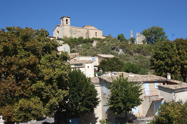
Эстублон (Estoublon, Estoublon)
- коммуна во Франции
 Hiking in Эстублон
Estoublon is a charming village located in the Alpes-de-Haute-Provence region of southeastern France. Its picturesque landscapes and proximity to the Verdon Gorge make it a great destination for hiking enthusiasts. Here are some things to consider when planning hikes in the Estoublon area:
Trail Options:
-
Local Trails: The surrounding region offers a variety of hiking trails that cater to different skill levels. Many paths lead through beautiful countryside, including forests, vineyards, and scenic viewpoints.
-
Verdon Gorge: A short drive from Estoublon will take you to the stunning Verdon Gorge, known for its turquoise waters and dramatic cliffs. The trails here range from easy walks along the rim to more challenging hikes that lead down into the gorge.
-
Mountain Routes: The nearby mountains, including the Lure Mountain, provide numerous hiking opportunities. You can enjoy panoramic views over the Provencal landscape and even spot local wildlife.
Hiking Tips:
- Preparation: Always check the weather forecast before heading out, as conditions can change quickly in mountainous regions.
- Hydration and Snacks: Carry plenty of water and nutritious snacks to keep your energy up during hikes.
- Navigation: Familiarize yourself with trail maps or consider using a GPS device. It's easy to get lost in less-trafficked areas.
- Wildlife: Respect local wildlife and keep a safe distance. Don't feed the animals, as this can disrupt their natural foraging behaviors.
Best Time to Hike:
- Spring and Fall: These seasons usually offer mild temperatures and fewer crowds. Wildflowers bloom in spring, enhancing the beautiful scenery.
- Summer: While summer can be hot, early morning hikes can be very rewarding, and swimming in mountain lakes provides a perfect way to cool off.
Local Attractions:
After your hikes, consider exploring the quaint village of Estoublon, where you can enjoy local cuisine and wine.
Whether you’re an experienced hiker or a beginner, Estoublon provides a picturesque backdrop for outdoor adventure in the heart of Provence. Make sure to research maps and trails before you go, and enjoy the stunning natural beauty the region has to offer!
- Страна:

- Почтовый код: 04270
- Координаты: 43° 56' 33" N, 6° 10' 17" E


- GPS треки (wikiloc): [Ссылка]
- Площадь: 33.85 кв.км
- Население: 480
- Википедия русская: wiki(ru)
- Википедия английская: wiki(en)
- Википедия национальная: wiki(fr)
- Хранилище Wikidata: Wikidata: Q865155
- Катеория в википедии: [Ссылка]
- код Freebase: [/m/03m7wm1]
- код Freebase: [/m/03m7wm1]
- код GeoNames: Альт: [3019521]
- код GeoNames: Альт: [3019521]
- номер SIREN: [210400842]
- номер SIREN: [210400842]
- код муниципалитета INSEE: 04084
- код муниципалитета INSEE: 04084
Граничит с регионами:

Мезель
- коммуна во Франции
Hiking in Мезель
Mézel is a picturesque village located in the Provence-Alpes-Côte d'Azur region of France, surrounded by beautiful landscapes and offering a variety of hiking opportunities. The area is characterized by its scenic trails, rolling hills, and diverse flora and fauna....
- Страна:
- Почтовый код: 04270
- Координаты: 43° 59' 47" N, 6° 11' 46" E
- GPS треки (wikiloc): [Ссылка]
- Площадь: 21.36 кв.км
- Население: 662


Сен-Жанне
- коммуна во Франции
Hiking in Сен-Жанне
Saint-Jeannet is a charming village located in the Alpes-de-Haute-Provence region of southeastern France. This area is known for its stunning natural landscapes, making it an excellent destination for hiking enthusiasts. Here’s what you can expect when hiking around Saint-Jeannet:...
- Страна:
- Почтовый код: 04270
- Координаты: 43° 57' 46" N, 6° 7' 37" E
- GPS треки (wikiloc): [Ссылка]
- Площадь: 21.14 кв.км
- Население: 63

Мажастр
- коммуна во Франции
Hiking in Мажастр
Majastres is a small village located in the Alpes-de-Haute-Provence region of France, known for its stunning natural beauty and outdoor activities, including hiking. Nestled in the scenic landscapes of the Southern Alps, it offers various trails that cater to different skill levels, making it a great destination for both novice and experienced hikers....
- Страна:
- Почтовый код: 04270
- Координаты: 43° 54' 48" N, 6° 17' 20" E
- GPS треки (wikiloc): [Ссылка]
- Площадь: 29.85 кв.км
- Население: 3
Сен-Жюр
- коммуна во Франции
Hiking in Сен-Жюр
Saint-Jurs, a small village in the Alpes-de-Haute-Provence region of France, offers a variety of hiking opportunities for outdoor enthusiasts. Nestled in a picturesque setting, the area is characterized by stunning landscapes, rolling hills, and scenic views of the surrounding mountains....
- Страна:
- Почтовый код: 04410
- Координаты: 43° 53' 55" N, 6° 11' 59" E
- GPS треки (wikiloc): [Ссылка]
- Высота над уровнем моря: 925 м m
- Площадь: 33.59 кв.км
- Население: 139

Сене
- коммуна во Франции
Hiking in Сене
Senez is a charming commune located in the Alpes-de-Haute-Provence region of southeastern France. It is surrounded by natural beauty, making it a great destination for hiking enthusiasts. Here’s an overview of what you can expect when hiking in the Senez area:...
- Страна:
- Почтовый код: 04270
- Координаты: 43° 54' 49" N, 6° 24' 25" E
- GPS треки (wikiloc): [Ссылка]
- Площадь: 70.27 кв.км
- Население: 166

Бра-д’Асс
- коммуна во Франции
Hiking in Бра-д’Асс
Bras-d'Asse is a charming small village located in the Alpes-de-Haute-Provence region of France. It's nestled in a scenic area known for its stunning natural landscapes, which makes it a lovely destination for hiking enthusiasts. Here are some key points to consider if you're planning a hiking trip to Bras-d'Asse:...
- Страна:
- Почтовый код: 04270
- Координаты: 43° 55' 32" N, 6° 7' 32" E
- GPS треки (wikiloc): [Ссылка]
- Высота над уровнем моря: 633 м m
- Площадь: 26.1 кв.км
- Население: 580
- Веб сайт: [Ссылка]

Бейн
- коммуна во Франции
Hiking in Бейн
Beynes is a charming village located in the Alpes-de-Haute-Provence region of France, surrounded by stunning natural landscapes that are ideal for hiking enthusiasts. The area is characterized by its rugged terrain, picturesque valleys, and panoramic views of the mountains, making it a great destination for outdoor activities....
- Страна:
- Почтовый код: 04270
- Координаты: 43° 59' 35" N, 6° 12' 8" E
- GPS треки (wikiloc): [Ссылка]
- Площадь: 41.24 кв.км
- Население: 126