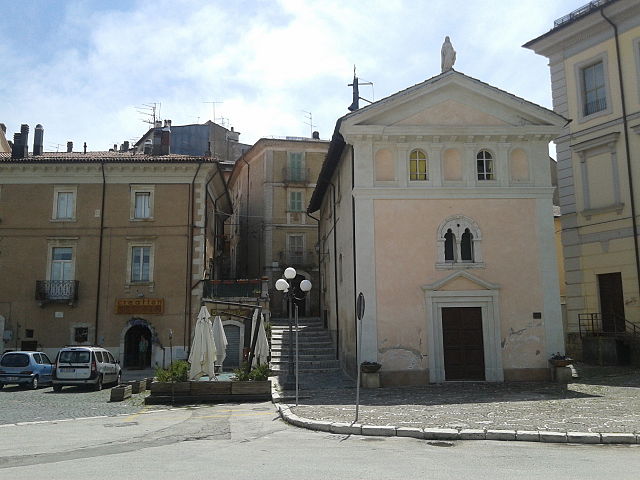
Фаньяно-Альто (Fagnano Alto, Fagnano Alto)
.svg)
- коммуна Италии
 Hiking in Фаньяно-Альто
Fagnano Alto is a picturesque village located in the Abruzzo region of Italy, surrounded by beautiful landscapes that are perfect for hiking enthusiasts. The area is characterized by its stunning natural beauty, medieval architecture, and proximity to the Gran Sasso e Monti della Laga National Park.
Hiking Trails
-
Gran Sasso National Park: This park is one of the main attractions for hikers, offering a range of trails suitable for all levels. Trails vary from easy walks to challenging climbs, with breathtaking views of the surrounding mountains.
-
Local Trails: There are numerous local paths around Fagnano Alto that can take you through forests, past rivers, and to panoramic viewpoints over the valley. Some trails may lead you to hidden gems like ancient ruins or tranquil spots perfect for a break.
-
Historical Routes: Some hikes might include visits to nearby historical sites, such as old churches or fortifications that reflect the rich history of the region.
Tips for Hiking in Fagnano Alto
-
Preparation: Always check the weather conditions and trail maps before heading out. Carry enough water, snacks, and basic first-aid supplies.
-
Footwear: Proper hiking shoes are essential for comfort and safety, especially on rocky or uneven terrain.
-
Guided Tours: If you're not familiar with the area, consider joining a guided hiking tour. Local guides can provide insights into the history and ecology of the region.
-
Leave No Trace: Respect nature by following the Leave No Trace principles. Take your litter with you and stay on marked trails to preserve the environment.
-
Wildlife: Keep an eye out for the diverse wildlife that inhabits the region, but observe from a distance and do not feed animals.
By exploring the various trails around Fagnano Alto, you can enjoy a wonderful mix of outdoor adventure, natural beauty, and cultural experiences. Whether you are a seasoned hiker or a beginner, the area has something to offer for everyone.
- Страна:

- Почтовый код: 67020
- Телефонный код: 0862
- Код автомобильного номера: AQ
- Координаты: 42° 15' 16" N, 13° 34' 31" E


- GPS треки (wikiloc): [Ссылка]
- Высота над уровнем моря: 665 м m
- Площадь: 24.64 кв.км
- Население: 416
- Веб сайт: http://www.comunefagnanoalto.it
- Википедия русская: wiki(ru)
- Википедия английская: wiki(en)
- Википедия национальная: wiki(it)
- Хранилище Wikidata: Wikidata: Q50091
- Катеория в википедии: [Ссылка]
- код Freebase: [/m/0fg4rb]
- код GeoNames: Альт: [6536398]
- ID отношения в OpenStreetMap: [49119]
- код TGN: [7047558]
- код Цифрового атласа Римской империи: [26570]
- Google Maps Customer ID: [290851176775805760]
- код ISTAT: 066042
- кадастровый код Италии: D465
Граничит с регионами:


Капорчано
- Коммуна Италии
Hiking in Капорчано
Caporciano is a charming village located in the heart of the Abruzzo region of Italy. It’s surrounded by beautiful natural landscapes, making it a great spot for hiking enthusiasts. Here are some highlights of hiking in and around Caporciano:...
- Страна:
- Почтовый код: 67020
- Телефонный код: 0862
- Код автомобильного номера: AQ
- Координаты: 42° 15' 6" N, 13° 40' 26" E
- GPS треки (wikiloc): [Ссылка]
- Высота над уровнем моря: 836 м m
- Площадь: 18.62 кв.км
- Население: 215
- Веб сайт: [Ссылка]


Фонтеккьо
- коммуна Италии
Hiking in Фонтеккьо
Fontecchio is a charming and picturesque village located in the Abruzzo region of Italy, surrounded by beautiful natural landscapes that are perfect for hiking enthusiasts. The area is known for its stunning mountainous terrain, which is part of the Gran Sasso e Monti della Laga National Park, making it an excellent destination for outdoor activities....
- Страна:
- Почтовый код: 67020
- Телефонный код: 0862
- Код автомобильного номера: AQ
- Координаты: 42° 13' 50" N, 13° 36' 24" E
- GPS треки (wikiloc): [Ссылка]
- Высота над уровнем моря: 668 м m
- Площадь: 16.86 кв.км
- Население: 341
- Веб сайт: [Ссылка]


Прата-д'Ансидония
- коммуна Италии
Hiking in Прата-д'Ансидония
Prata d'Ansidonia is a beautiful area located in the Abruzzo region of Italy, surrounded by stunning landscapes and rich biodiversity. It’s a relatively less-known hiking destination, making it perfect for those seeking tranquility and nature....
- Страна:
- Почтовый код: 67020
- Телефонный код: 0862
- Код автомобильного номера: AQ
- Координаты: 42° 16' 44" N, 13° 36' 33" E
- GPS треки (wikiloc): [Ссылка]
- Высота над уровнем моря: 846 м m
- Площадь: 19.65 кв.км
- Население: 486
- Веб сайт: [Ссылка]

Рокка-ди-Меццо
- коммуна Италии
Hiking in Рокка-ди-Меццо
Rocca di Mezzo, located in the Apennine Mountains of central Italy, is a beautiful destination for hiking enthusiasts. Known for its stunning landscapes, rich biodiversity, and charming medieval villages, it offers a variety of trails suitable for different skill levels. Here are some key points about hiking in Rocca di Mezzo:...
- Страна:
- Почтовый код: 67048
- Телефонный код: 0862
- Код автомобильного номера: AQ
- Координаты: 42° 12' 21" N, 13° 31' 13" E
- GPS треки (wikiloc): [Ссылка]
- Высота над уровнем моря: 1329 м m
- Площадь: 90.55 кв.км
- Население: 1474
- Веб сайт: [Ссылка]


Сан-Деметрио-не'Вестини
- коммуна Италии
Hiking in Сан-Деметрио-не'Вестини
San Demetrio ne' Vestini is a charming municipality located in the province of L'Aquila in the Abruzzo region of Italy. It's nestled in a mountainous area, making it a wonderful destination for hiking enthusiasts. Here are some highlights about hiking in and around San Demetrio ne' Vestini:...
- Страна:
- Почтовый код: 67028
- Телефонный код: 0862
- Код автомобильного номера: AQ
- Координаты: 42° 17' 26" N, 13° 33' 22" E
- GPS треки (wikiloc): [Ссылка]
- Высота над уровнем моря: 662 м m
- Площадь: 16.49 кв.км
- Население: 1909
- Веб сайт: [Ссылка]