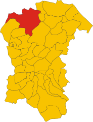
Фариндола (Farindola, Farindola)
.svg)
- коммуна Италии
 Hiking in Фариндола
Farindola is a charming village located in the Gran Sasso e Monti della Laga National Park in Italy, offering a variety of hiking opportunities that cater to different skill levels and preferences. The surrounding landscape is characterized by stunning mountain scenery, rich biodiversity, and numerous trails that explore both natural and cultural sites. Here are some aspects to consider when hiking in and around Farindola:
Trails and Routes
-
Gran Sasso Trail: This is one of the most popular hiking routes, leading you through the majestic mountains of the Gran Sasso region. The trail offers breathtaking views, especially from higher elevations.
-
Sentiero della Libertà: This historical trail connects different villages in the area and provides insight into the local history, as well as beautiful nature views. The trail is well-marked and is accessible for various levels of hikers.
-
Mount Prena: For more experienced hikers, a trek to Mount Prena can be an exhilarating adventure. The ascent can be challenging, but the panoramic views from the summit are rewarding.
Flora and Fauna
Hikers in Farindola can enjoy a diverse range of flora and fauna. The region features a mix of forests, meadows, and rocky landscapes, home to various wildlife such as deer, foxes, and numerous bird species.
Weather and Conditions
- Best Time to Hike: The spring and early autumn months (April to June and September to October) typically offer the best weather conditions for hiking, with mild temperatures and clearer skies. However, always check weather conditions, as mountain weather can change rapidly.
- Preparation: It’s important to wear proper hiking boots, dress in layers, and carry enough water and snacks. Some trails may be rugged, so ensure you're comfortable with the trail conditions.
Local Culture
While hiking, take the opportunity to explore the local culture. Farindola is known for its traditional cuisine, including handmade pasta and local cheeses. Consider stopping by local eateries for a taste of the region's culinary offerings.
Safety Tips
- Always inform someone about your hiking plans and expected return time.
- Carry a map or GPS device, as not all trails may be well-marked.
- Be aware of your limitations and choose trails that match your experience level.
Hiking in Farindola can be a truly enriching experience, combining physical activity with the beauty of nature and the charm of local culture. Enjoy your adventure!
- Страна:

- Почтовый код: 65010
- Телефонный код: 085
- Код автомобильного номера: PE
- Координаты: 42° 26' 30" N, 13° 49' 21" E


- GPS треки (wikiloc): [Ссылка]
- Высота над уровнем моря: 530 м m
- Площадь: 45.47 кв.км
- Население: 1456
- Веб сайт: http://www.comune.farindola.pe.it
- Википедия русская: wiki(ru)
- Википедия английская: wiki(en)
- Википедия национальная: wiki(it)
- Хранилище Wikidata: Wikidata: Q51364
- Катеория в википедии: [Ссылка]
- код Freebase: [/m/0fg8p1]
- код GeoNames: Альт: [6540725]
- код VIAF: Альт: [249966661]
- ID отношения в OpenStreetMap: [42009]
- код LCNAF: Альт: [no2012071604]
- код ISTAT: 068019
- кадастровый код Италии: D501
Граничит с регионами:


Кастель-дель-Монте
- коммуна Италии
Hiking in Кастель-дель-Монте
Castel del Monte, located in the Abruzzo region of Italy, is a beautiful area known for its stunning landscapes, rich cultural heritage, and diverse hiking opportunities. Here’s a guide to hiking in the region:...
- Страна:
- Почтовый код: 67023
- Телефонный код: 0862
- Код автомобильного номера: AQ
- Координаты: 42° 21' 56" N, 13° 43' 33" E
- GPS треки (wikiloc): [Ссылка]
- Высота над уровнем моря: 1346 м m
- Площадь: 58.03 кв.км
- Население: 437
- Веб сайт: [Ссылка]


Офена
- коммуна Италии
Hiking in Офена
Ofena is a small village located in the Abruzzo region of Italy, known for its stunning landscapes and proximity to the Gran Sasso e Monti della Laga National Park. Hiking in this area offers a unique combination of picturesque views, diverse flora and fauna, and a rich cultural heritage....
- Страна:
- Почтовый код: 67025
- Телефонный код: 0862
- Код автомобильного номера: AQ
- Координаты: 42° 19' 36" N, 13° 45' 35" E
- GPS треки (wikiloc): [Ссылка]
- Высота над уровнем моря: 531 м m
- Площадь: 36.9 кв.км
- Население: 471
- Веб сайт: [Ссылка]
Монтебелло-Ди-Бертона
- коммуна Италии
Hiking in Монтебелло-Ди-Бертона
Montebello di Bertona is a beautiful destination for hikers, located in the Abruzzo region of Italy. Nestled in the Gran Sasso e Monti della Laga National Park, it offers a range of trails that showcase stunning landscapes, diverse flora and fauna, and breathtaking views of the surrounding mountains and valleys....
- Страна:
- Почтовый код: 65010
- Телефонный код: 085
- Код автомобильного номера: PE
- Координаты: 42° 25' 0" N, 13° 52' 0" E
- GPS треки (wikiloc): [Ссылка]
- Высота над уровнем моря: 615 м m
- Площадь: 21.5 кв.км
- Население: 945
- Веб сайт: [Ссылка]

Пенне
- коммуна Италии
Hiking in Пенне
Hiking in Penne, a charming town in the Abruzzo region of Italy, offers you a rich blend of natural beauty, historical significance, and cultural experiences. Here are some highlights and tips for hiking in this picturesque area:...
- Страна:
- Почтовый код: 65017
- Телефонный код: 085
- Код автомобильного номера: PE
- Координаты: 42° 27' 0" N, 13° 55' 0" E
- GPS треки (wikiloc): [Ссылка]
- Высота над уровнем моря: 438 м m
- Площадь: 91.2 кв.км
- Население: 12113
- Веб сайт: [Ссылка]


Вилла-Чельера
- коммуна Италии
Hiking in Вилла-Чельера
Villa Celiera, a picturesque town nestled in the Abruzzo region of Italy, offers a fantastic hiking experience for nature enthusiasts. The area is characterized by its stunning landscapes, including rolling hills, dense forests, and panoramic views of the Gran Sasso and Maiella mountain ranges. Here are some key aspects of hiking in and around Villa Celiera:...
- Страна:
- Почтовый код: 65010
- Телефонный код: 085
- Код автомобильного номера: PE
- Координаты: 42° 22' 49" N, 13° 51' 33" E
- GPS треки (wikiloc): [Ссылка]
- Высота над уровнем моря: 714 м m
- Площадь: 13.18 кв.км
- Население: 652
- Веб сайт: [Ссылка]
Арсита
- коммуна Италии
Hiking in Арсита
Arsita is a charming village located in the Teramo province of the Abruzzo region in Italy. It is nestled in the beautiful Gran Sasso and Monti della Laga National Park, which offers a range of hiking opportunities for outdoor enthusiasts....
- Страна:
- Почтовый код: 64031
- Телефонный код: 0861
- Код автомобильного номера: TE
- Координаты: 42° 30' 8" N, 13° 47' 4" E
- GPS треки (wikiloc): [Ссылка]
- Высота над уровнем моря: 470 м m
- Площадь: 34.14 кв.км
- Население: 812
- Веб сайт: [Ссылка]