Фазано (Fasano, Fasano)
.svg)
- коммуна Италии
 Hiking in Фазано
Fasano, located in the Puglia region of Italy, offers a unique and scenic experience for hikers. The area is characterized by rolling hills, olive groves, ancient masserie (farmhouses), and coastal views, making it a great destination for nature lovers and outdoor enthusiasts.
Here are some highlights for hiking in Fasano:
-
Nature Reserves: The nearby Selva di Fasano, a scenic forest area, provides a variety of trails through lush greenery. This area is ideal for hiking, bird-watching, and enjoying the tranquility of nature.
-
Coastal Trails: Fasano is close to the Adriatic Sea, and there are coastal paths that offer stunning views of the coastline. These trails often lead to secluded beaches and coves, perfect for a refreshing break after a hike.
-
Historical Landmarks: While hiking, you can explore various historical sites, such as the ruins of ancient towns or the famous Trulli houses in nearby Alberobello. The combination of cultural heritage and natural beauty makes for a rich hiking experience.
-
Wildlife: The region is home to diverse flora and fauna. Keep an eye out for local wildlife, including various bird species, as you hike through different ecosystems.
-
Varied Difficulty Levels: Trails in and around Fasano cater to different skill levels, making it accessible for both novice hikers and seasoned trekkers. From gentle walks to more challenging hikes, there’s something for everyone.
-
Local Guides: Consider joining a guided hiking tour for a deeper understanding of the local landscape, history, and ecology. Local guides can share valuable insights and help you navigate the best hiking spots.
-
Seasonal Considerations: The best time for hiking in Fasano is during spring and autumn when the weather is mild. Summers can be quite hot, so early morning or late afternoon hikes are recommended.
When planning your hike, be sure to stay hydrated, wear appropriate hiking gear, and carry a map or GPS device. Enjoy the rich natural and cultural heritage of Fasano!
- Страна:

- Почтовый код: 72015
- Телефонный код: 080
- Код автомобильного номера: BR
- Координаты: 40° 50' 0" N, 17° 22' 0" E


- GPS треки (wikiloc): [Ссылка]
- Высота над уровнем моря: 111 м m
- Площадь: 131.72 кв.км
- Население: 39683
- Веб сайт: http://www.comune.fasano.br.it/
- Википедия русская: wiki(ru)
- Википедия английская: wiki(en)
- Википедия национальная: wiki(it)
- Хранилище Wikidata: Wikidata: Q51865
- Катеория в википедии: [Ссылка]
- код Freebase: [/m/0f5l1v]
- код GeoNames: Альт: [6540025]
- код VIAF: Альт: [247313848]
- ID отношения в OpenStreetMap: [40778]
- место в MusicBrainz: [18fbc593-e533-4bb3-962f-ce24f30a566a]
- код темы Quora: [Fasano]
- UN/LOCODE: [ITZAX]
- код ISTAT: 074007
- кадастровый код Италии: D508
Граничит с регионами:


Бриндизи
- коммуна Италии
Hiking in Бриндизи
Brindisi, located in the Apulia region of southern Italy, offers a variety of hiking opportunities that showcase its beautiful landscapes, coastal scenery, and historical sites. Here are some key hiking spots and experiences in and around Brindisi:...
- Страна:
- Почтовый код: 72100
- Телефонный код: 0831
- Код автомобильного номера: BR
- Координаты: 40° 38' 18" N, 17° 56' 45" E
- GPS треки (wikiloc): [Ссылка]
- Высота над уровнем моря: 15 м m
- Площадь: 332.98 кв.км
- Население: 88126
- Веб сайт: [Ссылка]


Альберобелло
- коммуна Италии
Hiking in Альберобелло
Alberobello, located in the Apulia region of southern Italy, is most famous for its unique trulli - traditional Apulian stone huts with conical roofs. While Alberobello itself is not primarily known for hiking, there are several wonderful walking opportunities in the surrounding areas that can enhance your outdoor experience....
- Страна:
- Почтовый код: 70011
- Телефонный код: 080
- Код автомобильного номера: BA
- Координаты: 40° 47' 3" N, 17° 14' 15" E
- GPS треки (wikiloc): [Ссылка]
- Высота над уровнем моря: 416 м m
- Площадь: 40 кв.км
- Население: 10725
- Веб сайт: [Ссылка]


Локоротондо
- коммуна Италии
Hiking in Локоротондо
Locorotondo is a picturesque town in the Apulia region of Italy, known for its charming whitewashed buildings, winding streets, and beautiful views of the surrounding countryside. While Locorotondo itself is not primarily recognized as a hiking destination, the surrounding area offers a variety of trails and opportunities for outdoor activities....
- Страна:
- Почтовый код: 70010
- Телефонный код: 080
- Код автомобильного номера: BA
- Координаты: 40° 45' 0" N, 17° 19' 0" E
- GPS треки (wikiloc): [Ссылка]
- Высота над уровнем моря: 410 м m
- Площадь: 48.19 кв.км
- Население: 14190
- Веб сайт: [Ссылка]


Монополи
- коммуна Италии
Hiking in Монополи
Monopoli, located in the Apulia region of Italy, is known for its beautiful coastline, picturesque old town, and surrounding natural landscapes. While it’s primarily recognized for its stunning beaches and historic sites, there are also some excellent opportunities for hiking and outdoor activities in and around the area. Here are some aspects to consider if you're planning to hike in Monopoli:...
- Страна:
- Почтовый код: 70043
- Телефонный код: 080
- Код автомобильного номера: BA
- Координаты: 40° 57' 0" N, 17° 18' 0" E
- GPS треки (wikiloc): [Ссылка]
- Высота над уровнем моря: 9 м m
- Площадь: 157.89 кв.км
- Население: 48964
- Веб сайт: [Ссылка]


Чистернино
- коммуна Италии
Hiking in Чистернино
Cisternino, located in the Puglia region of Italy, is a charming town known for its beautiful scenery, white-washed buildings, and rich agricultural landscapes. Here are some key points to consider when hiking in and around Cisternino:...
- Страна:
- Почтовый код: 72014
- Телефонный код: 080
- Код автомобильного номера: BR
- Координаты: 40° 45' 0" N, 17° 25' 0" E
- GPS треки (wikiloc): [Ссылка]
- Высота над уровнем моря: 392 м m
- Площадь: 54.17 кв.км
- Население: 11553
- Веб сайт: [Ссылка]
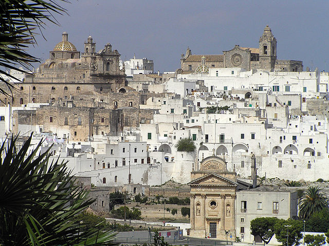

Остуни
- коммуна Италии
Hiking in Остуни
Hiking in Ostuni, a picturesque town in the Apulia region of Italy, offers a unique blend of stunning landscapes, rich history, and beautiful Mediterranean climate. Here's what you can expect when hiking in this area:...
- Страна:
- Почтовый код: 72017
- Телефонный код: 0831
- Код автомобильного номера: BR
- Координаты: 40° 43' 56" N, 17° 34' 40" E
- GPS треки (wikiloc): [Ссылка]
- Высота над уровнем моря: 207 м m
- Площадь: 225.56 кв.км
- Население: 31197
- Веб сайт: [Ссылка]