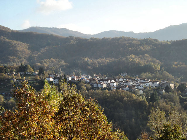
Фашия (Fascia, Liguria, Fascia)
.svg)
- коммуна Италии
 Hiking in Фашия
Fascia is a charming commune in the Liguria region of Italy, nestled in the hills above the Gulf of Genoa. While it’s not as widely known as other hiking destinations in Liguria, its scenic landscapes and proximity to the Ligurian Apennines make it a great option for those looking to explore the less-traveled paths of the Italian countryside.
Hiking Opportunities
-
Trail Networks: Fascia is part of the larger network of trails in the Ligurian region, which often connect to nearby towns and natural attractions. The paths usually weave through olive groves, forests, and offer stunning views of the surrounding hills and valleys.
-
Nature and Wildlife: The region is rich in biodiversity, making it an ideal spot for nature enthusiasts. Hikers may encounter local wildlife and a variety of plant species, especially in the spring when the flora is in full bloom.
-
Cultural Heritage: While hiking, you may also come across historical sites, such as old stone villages and churches, which provide insight into the area's cultural heritage. These landmarks enhance the hiking experience by adding a layer of history to the journey.
-
Scenic Views: Higher altitude trails offer breathtaking panoramic views of the Mediterranean Sea, especially during clear days. Sunset hikes can be particularly rewarding as the sky transforms with vibrant colors against the backdrop of the sea.
Trail Recommendations
-
Sentiero dei Muri (Wall Path): This hike showcases the region's unique dry stone walls, which have been built for centuries to create terraced farmland. It's a moderate trail that provides opportunities for photography and enjoying the landscapes.
-
Access to Alta Via dei Monti Liguri: Fascia is located not too far from the Alta Via dei Monti Liguri, an extensive trail spanning the Ligurian region. Depending on your experience level, you could easily connect to sections of this trail for a more extended hiking adventure.
Practical Tips
-
Weather Conditions: The best time to hike in Fascia is during the spring (April to June) and early autumn (September to October) when the weather is mild, and the trails are less crowded. Summers can be hot, so plan your hikes early in the day.
-
Gear and Preparation: Bring appropriate hiking gear, including sturdy shoes, a hat, sunscreen, plenty of water, and snacks. Some trails may not be well-marked, so having a map or GPS device is advisable.
-
Local Resources: Check in with local tourist information centers for maps, updates on trail conditions, and any guided hiking opportunities.
Conclusion
Hiking in Fascia, Liguria offers a unique experience that combines stunning natural beauty, cultural heritage, and tranquility away from the tourist crowds. Whether you're an experienced hiker or someone looking to enjoy a peaceful walk in nature, Fascia can provide a memorable outdoor adventure.
- Страна:

- Почтовый код: 16020
- Телефонный код: 010
- Код автомобильного номера: GE
- Координаты: 44° 33' 57" N, 9° 14' 15" E


- GPS треки (wikiloc): [Ссылка]
- Высота над уровнем моря: 900 м m
- Площадь: 11.25 кв.км
- Население: 71
- Веб сайт: http://www.comunedifascia.it
- Википедия русская: wiki(ru)
- Википедия английская: wiki(en)
- Википедия национальная: wiki(it)
- Хранилище Wikidata: Wikidata: Q266306
- Катеория в википедии: [Ссылка]
- код Freebase: [/m/0ghwc1]
- код GeoNames: Альт: [6536084]
- ID отношения в OpenStreetMap: [43287]
- код ISTAT: 010022
- кадастровый код Италии: D509
Граничит с регионами:

Каррега-Лигуре
- коммуна в регионе Пьемонт, Италия
Hiking in Каррега-Лигуре
Carrega Ligure is a beautiful destination for hiking enthusiasts, located in the picturesque region of Liguria, Italy. Nestled in the Apennine Mountains, it offers stunning landscapes characterized by lush forests, rolling hills, and scenic views....
- Страна:
- Почтовый код: 15060
- Телефонный код: 0143
- Код автомобильного номера: AL
- Координаты: 44° 37' 15" N, 9° 10' 33" E
- GPS треки (wikiloc): [Ссылка]
- Высота над уровнем моря: 958 м m
- Площадь: 55.26 кв.км
- Население: 86
- Веб сайт: [Ссылка]

Фонтанигорда
- коммуна Италии
Hiking in Фонтанигорда
Fontanigorda is a charming village located in the Apennine Mountains of northern Italy, and it offers a variety of hiking opportunities for outdoor enthusiasts. The area is characterized by its lush forests, scenic landscapes, and rich biodiversity, making it an ideal location for hikers looking to explore nature....
- Страна:
- Почтовый код: 16023
- Телефонный код: 010
- Код автомобильного номера: GE
- Координаты: 44° 32' 48" N, 9° 18' 17" E
- GPS треки (wikiloc): [Ссылка]
- Высота над уровнем моря: 800 м m
- Площадь: 16.16 кв.км
- Население: 264
- Веб сайт: [Ссылка]


Горрето
- коммуна Италии
Hiking in Горрето
Gorreto, a small municipality located in the Liguria region of Italy, is surrounded by breathtaking landscapes, making it an excellent destination for hiking enthusiasts. The area is characterized by its scenic valleys, lush forests, and stunning views of the surrounding mountains and hills. Here are some highlights about hiking in Gorreto:...
- Страна:
- Почтовый код: 16020
- Телефонный код: 010
- Код автомобильного номера: GE
- Координаты: 44° 36' 22" N, 9° 17' 33" E
- GPS треки (wikiloc): [Ссылка]
- Высота над уровнем моря: 533 м m
- Площадь: 18.88 кв.км
- Население: 93
- Веб сайт: [Ссылка]


Монтебруно
- коммуна Италии
Hiking in Монтебруно
Montebruno is a charming destination for hikers located in the Liguria region of Italy, known for its picturesque landscapes, lush greenery, and scenic trails. Here’s what you should know about hiking in Montebruno:...
- Страна:
- Почтовый код: 16025
- Телефонный код: 010
- Код автомобильного номера: GE
- Координаты: 44° 31' 34" N, 9° 14' 56" E
- GPS треки (wikiloc): [Ссылка]
- Высота над уровнем моря: 655 м m
- Площадь: 17.68 кв.км
- Население: 231
- Веб сайт: [Ссылка]


Пропата
- коммуна Италии
Hiking in Пропата
It seems there might be a slight misspelling in your query, as there isn't a widely recognized hiking destination called "Propata." If you meant "Propata," which is not a common name in hiking literature, I would recommend double-checking the spelling or providing more context....
- Страна:
- Почтовый код: 16027
- Телефонный код: 010
- Код автомобильного номера: GE
- Координаты: 44° 33' 53" N, 9° 11' 6" E
- GPS треки (wikiloc): [Ссылка]
- Высота над уровнем моря: 990 м m
- Площадь: 16.93 кв.км
- Население: 136
- Веб сайт: [Ссылка]


Ронданина
- коммуна Италии
Hiking in Ронданина
Rondanina is a small, picturesque village located in the Liguria region of Italy, nestled within the Apennine Mountains. It offers an idyllic setting for hiking enthusiasts, characterized by its rich natural beauty, charming landscapes, and a variety of trails suitable for all skill levels. Here are a few key points about hiking in Rondanina:...
- Страна:
- Почтовый код: 16025
- Телефонный код: 010
- Код автомобильного номера: GE
- Координаты: 44° 33' 45" N, 9° 13' 4" E
- GPS треки (wikiloc): [Ссылка]
- Высота над уровнем моря: 981 м m
- Площадь: 12.81 кв.км
- Население: 60
- Веб сайт: [Ссылка]


Ровеньо
- коммуна Италии
Hiking in Ровеньо
Rovegno is a beautiful destination for hiking enthusiasts, located in the heart of the Italian Apennines in the Liguria region. This area offers a range of hiking trails that cater to various skill levels, and it is known for its stunning landscapes, rich biodiversity, and charming local culture....
- Страна:
- Почтовый код: 16028
- Телефонный код: 010
- Код автомобильного номера: GE
- Координаты: 44° 34' 33" N, 9° 16' 44" E
- GPS треки (wikiloc): [Ссылка]
- Высота над уровнем моря: 658 м m
- Площадь: 44.09 кв.км
- Население: 511
- Веб сайт: [Ссылка]