Фенестрелле (Fenestrelle, Fenestrelle)

- коммуна Италии
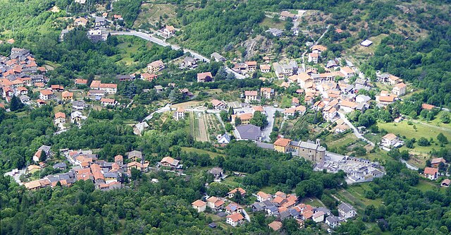
 Hiking in Фенестрелле
Fenestrelle, located in the Piedmont region of Italy, is known for its stunning natural beauty and historical significance. The area is particularly famous for the Fort of Fenestrelle, a remarkable fortress that offers a unique backdrop for hiking activities. Here’s an overview of what you can expect when hiking in Fenestrelle:
Trails and Routes
-
Fort of Fenestrelle: One of the most popular hiking routes starts from the village and leads up to the fort. The trail is steep and marked by historical significance, allowing hikers to enjoy both the natural beauty and the fascinating architecture of the fort itself.
-
Bessa Natural Park: Nearby, Bessa Natural Park offers various trails that wind through beautiful landscapes, featuring a mix of forests, rivers, and panoramic views of the surrounding Alps.
-
Montgenèvre: A bit further afield, hikers can access trails from Montgenèvre, leading into the French Alps. These paths offer a mix of difficulty levels and stunning mountain scenery.
Best Time to Hike
- Spring and Fall: The best times to hike in Fenestrelle are during the spring (April to June) and fall (September to October) when the weather is mild, and the landscape is vibrant with blooming flowers or autumn colors.
- Summer: Summer offers a warm climate, making it a popular time for hiking, but be prepared for possibly larger crowds on the well-known trails.
Preparation and Gear
- Footwear: Proper hiking boots with good ankle support are essential due to the varied terrain.
- Clothing: Dressing in layers is advisable due to potential weather changes and altitude variations.
- Water and Snacks: Always carry enough water and some snacks, especially on longer hikes.
Safety Tips
- Trail Maps: Have a good map or a GPS device, as some trails may not be well-marked.
- Weather Awareness: Be mindful of weather changes, especially in mountainous regions.
- Leave No Trace: Follow Leave No Trace principles to preserve the natural beauty of the area for future hikers.
Additional Activities
- Photography: The stunning landscapes offer fantastic opportunities for photography.
- Wildlife Watching: Depending on the season, you may spot various wildlife, including chamois and bird species native to the Alps.
Hiking in Fenestrelle combines nature, history, and adventure, making it a unique destination for both casual walkers and experienced hikers. Enjoy your hike!
- Страна:

- Почтовый код: 10060
- Телефонный код: 0121
- Код автомобильного номера: TO
- Координаты: 45° 2' 0" N, 7° 3' 0" E


- GPS треки (wikiloc): [Ссылка]
- Высота над уровнем моря: 1215 м m
- Площадь: 49.41 кв.км
- Население: 521
- Веб сайт: http://www.comune.fenestrelle.to.it
- Википедия русская: wiki(ru)
- Википедия английская: wiki(en)
- Википедия национальная: wiki(it)
- Хранилище Wikidata: Wikidata: Q9352
- Галерея изображений в википедии: [Ссылка]
- Катеория в википедии: [Ссылка]
- код Freebase: [/m/0g6w31]
- код GeoNames: Альт: [6538059]
- код VIAF: Альт: [148064054]
- ID отношения в OpenStreetMap: [43964]
- код ISTAT: 001103
- кадастровый код Италии: D532
Граничит с регионами:


Праджелато
- коммуна Италии
Hiking in Праджелато
Pragelato, located in the Susa Valley in the Piedmont region of Italy, is a fantastic destination for hiking enthusiasts. Nestled in the Alps, it is known for its stunning landscapes, diverse trails, and opportunities for outdoor activities year-round....
- Страна:
- Почтовый код: 10060
- Телефонный код: 0122
- Код автомобильного номера: TO
- Координаты: 45° 1' 0" N, 6° 57' 0" E
- GPS треки (wikiloc): [Ссылка]
- Высота над уровнем моря: 1518 м m
- Площадь: 89.2 кв.км
- Население: 786
- Веб сайт: [Ссылка]

Рур
- коммуна Италии
Hiking in Рур
Roure, located in the Piedmont region of Italy, is a charming town nestled in the Susa Valley. The area offers a multitude of hiking opportunities, characterized by stunning landscapes, rich history, and a diverse range of trails suitable for all skill levels....
- Страна:
- Почтовый код: 10060
- Телефонный код: 0121
- Код автомобильного номера: TO
- Координаты: 45° 0' 0" N, 7° 8' 0" E
- GPS треки (wikiloc): [Ссылка]
- Высота над уровнем моря: 750 м m
- Площадь: 59.37 кв.км
- Население: 832
- Веб сайт: [Ссылка]


Уссо
- коммуна в Италии
Hiking in Уссо
Usseaux is a charming mountain village located in the Province of Turin, part of the Piedmont region in Italy. Nestled in the Susa Valley, Usseaux is surrounded by the stunning peaks of the Alps, making it a beautiful destination for hiking enthusiasts....
- Страна:
- Почтовый код: 10060
- Телефонный код: 0121
- Код автомобильного номера: TO
- Координаты: 45° 3' 0" N, 7° 2' 0" E
- GPS треки (wikiloc): [Ссылка]
- Высота над уровнем моря: 1416 м m
- Площадь: 37.97 кв.км
- Население: 186
- Веб сайт: [Ссылка]


Масселло
- коммуна в Италии
Hiking in Масселло
Massello is a small village located in the Susa Valley of the Piedmont region in Italy, nestled within the beautiful backdrop of the Alps. It's a fantastic destination for hiking enthusiasts due to its stunning landscapes, diverse trails, and rich natural beauty....
- Страна:
- Почтовый код: 10060
- Телефонный код: 0121
- Код автомобильного номера: TO
- Координаты: 44° 58' 0" N, 7° 3' 0" E
- GPS треки (wikiloc): [Ссылка]
- Площадь: 38.26 кв.км
- Население: 52
- Веб сайт: [Ссылка]
Маттие
- коммуна Италии
Hiking in Маттие
Hiking in Mattie, Piedmont, offers a beautiful blend of scenic views and the tranquility of nature. The region is known for its stunning landscapes, including rolling hills, dense forests, and potentially some water bodies like rivers or lakes, depending on the exact area....
- Страна:
- Почтовый код: 10050
- Телефонный код: 0122
- Код автомобильного номера: TO
- Координаты: 45° 7' 0" N, 7° 7' 0" E
- GPS треки (wikiloc): [Ссылка]
- Высота над уровнем моря: 730 м m
- Площадь: 28.69 кв.км
- Население: 662
- Веб сайт: [Ссылка]

Меана-ди-Суза
- коммуна Италии
Hiking in Меана-ди-Суза
Meana di Susa is a picturesque village located in the Susa Valley, nestled in the Italian Alps near Turin. It offers a variety of hiking options for both beginners and experienced hikers, making it an appealing destination for outdoor enthusiasts. Here's what you should know about hiking in Meana di Susa:...
- Страна:
- Почтовый код: 10050
- Телефонный код: 0122
- Код автомобильного номера: TO
- Координаты: 45° 7' 26" N, 7° 3' 40" E
- GPS треки (wikiloc): [Ссылка]
- Высота над уровнем моря: 730 м m
- Площадь: 16.54 кв.км
- Население: 814
- Веб сайт: [Ссылка]