
Фьюмальбо (Fiumalbo, Fiumalbo)
.svg)
- коммуна Италии
 Hiking in Фьюмальбо
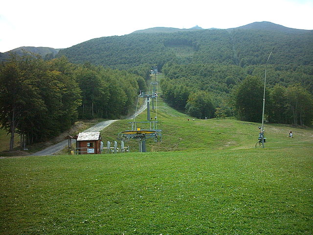
Fiumalbo is a charming village located in the Apennine mountains of northern Italy, within the Emilia-Romagna region. It's a wonderful destination for hiking enthusiasts, as it offers a variety of trails that showcase the stunning natural beauty of the area, with lush forests, meandering streams, and breathtaking mountain views.
Hiking Trails
-
Parco dell'Abetone e del Volatourse: This park provides a plethora of hiking opportunities. Trails vary in difficulty and length, catering to both beginners and experienced hikers. You can explore deep forests and enjoy the rich biodiversity of the region.
-
Sentiero della Libertà: This historical trail offers a unique perspective, as it follows paths that were used during World War II by partisans. The hike combines physical activity with history, allowing you to appreciate both the environment and the cultural significance of the area.
-
Il Monte Libro Aperto: A popular hike that leads you to the summit of Monte Libro Aperto, which provides panoramic views of the surrounding mountains and valleys. The trail is moderately challenging and is great for those seeking a rewarding climb.
-
Lago di Ponte e Lago delle Piane: These beautiful glacial lakes are accessible via scenic trails. Hiking around the lakes offers stunning reflections and a chance to observe local wildlife.
Recommendations
- Best Time to Hike: Late spring to early autumn is ideal for hiking in Fiumalbo, as the weather is generally mild and the trails are in good condition.
- Gear: Wear sturdy hiking boots and carry plenty of water and snacks. A map or GPS device can be helpful, especially if you're venturing on less marked paths.
- Local Guidance: Consider joining a guided tour if you’re unfamiliar with the area, as local guides can provide insights into the natural history and ecology of the region.
- Leave No Trace: Be mindful of your impact on the environment. Stay on marked trails, and pack out whatever you bring in.
Fiumalbo not only provides beautiful hiking opportunities but also allows you to explore quaint local culture and delicious Italian cuisine. Enjoy your hike!
- Страна:

- Почтовый код: 41022
- Телефонный код: 0536
- Код автомобильного номера: MO
- Координаты: 44° 10' 45" N, 10° 38' 50" E


- GPS треки (wikiloc): [Ссылка]
- Высота над уровнем моря: 935 м m
- Площадь: 39.14 кв.км
- Население: 1240
- Веб сайт: http://www.comune.fiumalbo.mo.it/
- Википедия русская: wiki(ru)
- Википедия английская: wiki(en)
- Википедия национальная: wiki(it)
- Хранилище Wikidata: Wikidata: Q100052
- Катеория в википедии: [Ссылка]
- код Freebase: [/m/0gkgb7]
- код GeoNames: Альт: [6536725]
- код VIAF: Альт: [153809446]
- ID отношения в OpenStreetMap: [42885]
- код LCNAF: Альт: [n2004017253]
- UN/LOCODE: [ITFMB]
- код ISTAT: 036014
- кадастровый код Италии: D617
Граничит с регионами:
Фанано
- коммуна Италии
Hiking in Фанано
Fanano is a picturesque town located in the Appennino Modenese mountain range in Italy, known for its stunning landscapes, rich history, and vibrant culture. Hiking in and around Fanano offers a variety of trails suitable for all skill levels, from leisurely walks to challenging treks....
- Страна:
- Почтовый код: 41021
- Телефонный код: 0536
- Код автомобильного номера: MO
- Координаты: 44° 12' 45" N, 10° 47' 48" E
- GPS треки (wikiloc): [Ссылка]
- Высота над уровнем моря: 640 м m
- Площадь: 89.91 кв.км
- Население: 2946
- Веб сайт: [Ссылка]


Пьевепелаго
- коммуна Италии
Hiking in Пьевепелаго
Pievepelago is a beautiful village located in the Modena province of Italy, nestled in the Apennine Mountains. This region is renowned for its stunning landscapes, rich biodiversity, and a variety of hiking trails that cater to different skill levels. Here are some key points about hiking in Pievepelago:...
- Страна:
- Почтовый код: 41027
- Телефонный код: 0536
- Код автомобильного номера: MO
- Координаты: 44° 12' 20" N, 10° 37' 21" E
- GPS треки (wikiloc): [Ссылка]
- Высота над уровнем моря: 701 м m
- Площадь: 76.54 кв.км
- Население: 2317
- Веб сайт: [Ссылка]

Риолунато
- коммуна Италии
Hiking in Риолунато
Riolunato, located in the Modena province of Italy, is a charming destination for outdoor enthusiasts and hikers. Nestled in the Apennine Mountains, it offers a variety of trails that cater to different skill levels, making it an excellent spot for both novice and experienced hikers....
- Страна:
- Почтовый код: 41020
- Телефонный код: 0536
- Код автомобильного номера: MO
- Координаты: 44° 14' 0" N, 10° 39' 0" E
- GPS треки (wikiloc): [Ссылка]
- Высота над уровнем моря: 716 м m
- Площадь: 44.91 кв.км
- Население: 688
- Веб сайт: [Ссылка]


Сестола
- коммуна Италии
Hiking in Сестола
Sestola is a picturesque village in the Apennine Mountains of Italy, known for its stunning landscapes and a wealth of hiking opportunities. Here's an overview to help you make the most of your hiking experience in Sestola:...
- Страна:
- Почтовый код: 41029
- Телефонный код: 0536
- Код автомобильного номера: MO
- Координаты: 44° 14' 0" N, 10° 46' 0" E
- GPS треки (wikiloc): [Ссылка]
- Высота над уровнем моря: 1020 м m
- Площадь: 52.47 кв.км
- Население: 2490
- Веб сайт: [Ссылка]

Корелья-Антельминелли
- коммуна Италии
Hiking in Корелья-Антельминелли
Coreglia Antelminelli is a charming village located in the Garfagnana region of Tuscany, Italy. It offers a picturesque setting for hikers and outdoor enthusiasts. The area is characterized by beautiful landscapes, including hills, valleys, and lush forests. Here are some insights into hiking in and around Coreglia Antelminelli:...
- Страна:
- Почтовый код: 55025
- Телефонный код: 0583
- Код автомобильного номера: LU
- Координаты: 44° 3' 52" N, 10° 31' 35" E
- GPS треки (wikiloc): [Ссылка]
- Высота над уровнем моря: 595 м m
- Площадь: 52.94 кв.км
- Население: 5220
- Веб сайт: [Ссылка]