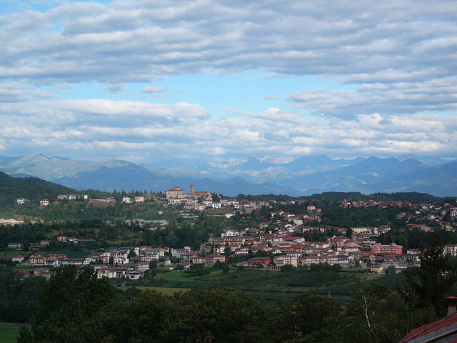
Фрабоза-Соттана (Frabosa Sottana, Frabosa Sottana)
- коммуна Италии
 Hiking in Фрабоза-Соттана
Frabosa Sottana is a picturesque village located in the Piedmont region of Italy, nestled in the Cuneo province and part of the Maritime Alps. The area is renowned for its stunning landscapes, rich biodiversity, and a variety of hiking trails, making it an ideal destination for outdoor enthusiasts.
Hiking Highlights in Frabosa Sottana:
-
Diverse Trails: The region offers a range of hiking trails, from easy walks suitable for families to challenging routes for experienced hikers. Trails often lead through lush forests, meadows, and alongside streams.
-
Natural Beauty: The hikes in Frabosa Sottana provide breathtaking views of the surrounding mountains. You will have opportunities to see local wildlife, including various birds and possibly deer, as well as an array of alpine flora.
-
Local Geology: The trails frequently benefit from the unique geological features of the Maritime Alps, which include beautiful rock formations and glacial valleys, adding to the scenery.
-
Cultural Aspects: Along the trails, you may encounter small chapels and farms that highlight the local culture and history. Interacting with the locals can provide insights into traditional mountain life.
-
Accessibility: The village itself serves as a great base for hiking, with nearby access to many trails. Depending on the season, you may also find options for snowshoeing or cross-country skiing in winter.
Popular Hiking Routes:
-
Cima delle Saline: A moderately challenging hike leading to one of the higher peaks in the area, offering panoramic views.
-
Trail to Rifugio Gola di Fera: This trail is great for a day hike, where you can enjoy mountain scenery and end with a visit to a mountain hut for some local cuisine.
Tips for Hiking in Frabosa Sottana:
-
Prepare Adequately: Make sure to pack enough water, snacks, and appropriate hiking gear, especially if you plan on tackling more difficult trails.
-
Check the Weather: The weather can change quickly in the mountains, so it's crucial to check forecasts before heading out.
-
Leave No Trace: Preserve the natural beauty of the area by following Leave No Trace principles—take your trash with you and respect wildlife.
-
Guided Tours: If you're unfamiliar with the area, consider joining a guided hike to learn more about the ecology and history of the region.
Overall, hiking in Frabosa Sottana can be a rewarding experience, combining the thrill of adventure with the beauty of the Italian Alps. Enjoy your hike!
- Страна:

- Почтовый код: 12083
- Телефонный код: 0174
- Код автомобильного номера: CN
- Координаты: 44° 18' 0" N, 7° 48' 0" E


- GPS треки (wikiloc): [Ссылка]
- Высота над уровнем моря: 641 м m
- Площадь: 37.64 кв.км
- Население: 1517
- Веб сайт: http://www.comune.frabosa-sottana.cn.it
- Википедия русская: wiki(ru)
- Википедия английская: wiki(en)
- Википедия национальная: wiki(it)
- Хранилище Wikidata: Wikidata: Q20059
- Катеория в википедии: [Ссылка]
- код Freebase: [/m/0gb9lc]
- код GeoNames: Альт: [6543444]
- ID отношения в OpenStreetMap: [42958]
- код ISTAT: 004091
- кадастровый код Италии: D752
Граничит с регионами:
Фрабоза-Сопрана
- коммуна Италии
Hiking in Фрабоза-Сопрана
Frabosa Soprana is a charming village located in the Piedmont region of Italy, nestled within the Maritime Alps. It's known for its stunning natural landscapes, and it serves as an excellent gateway for hiking enthusiasts. Here are some highlights and recommendations for hiking in and around Frabosa Soprana:...
- Страна:
- Почтовый код: 12082
- Телефонный код: 0174
- Код автомобильного номера: CN
- Координаты: 44° 17' 14" N, 7° 48' 25" E
- GPS треки (wikiloc): [Ссылка]
- Высота над уровнем моря: 891 м m
- Площадь: 47.14 кв.км
- Население: 754
- Веб сайт: [Ссылка]
Мальяно-Альпи
- коммуна Италии
Hiking in Мальяно-Альпи
Magliano Alpi is a charming village located in the Piedmont region of northern Italy, nestled within the scenic landscape of the Maritime Alps. The area offers a variety of hiking opportunities that cater to different skill levels, ranging from leisurely walks to more challenging treks....
- Страна:
- Почтовый код: 12060
- Телефонный код: 0174
- Код автомобильного номера: CN
- Координаты: 44° 27' 0" N, 7° 48' 0" E
- GPS треки (wikiloc): [Ссылка]
- Высота над уровнем моря: 403 м m
- Площадь: 33.22 кв.км
- Население: 2206
- Веб сайт: [Ссылка]
Монастеро-ди-Васко
- коммуна Италии
Hiking in Монастеро-ди-Васко
Monastero di Vasco is a charming hamlet in the scenic region of Piedmont, Italy, surrounded by beautiful landscapes and a rich cultural heritage. Hiking in this area can offer you a mix of nature, history, and picturesque views. Here are some key points to consider when planning your hike in and around Monastero di Vasco:...
- Страна:
- Почтовый код: 12080
- Телефонный код: 0174
- Код автомобильного номера: CN
- Координаты: 44° 20' 0" N, 7° 49' 0" E
- GPS треки (wikiloc): [Ссылка]
- Высота над уровнем моря: 508 м m
- Площадь: 17.44 кв.км
- Население: 1307
- Веб сайт: [Ссылка]

Роккафорте-Мондови
- коммуна Италии
Hiking in Роккафорте-Мондови
Roccaforte Mondovì is a charming village nestled in the Piedmont region of Italy, surrounded by the stunning landscape of the Maritime Alps. This area is known for its diverse hiking opportunities, offering trails for various skill levels and preferences. Here are some highlights and tips for hiking in Roccaforte Mondovì:...
- Страна:
- Почтовый код: 12088
- Телефонный код: 0174
- Код автомобильного номера: CN
- Координаты: 44° 19' 0" N, 7° 45' 0" E
- GPS треки (wikiloc): [Ссылка]
- Высота над уровнем моря: 574 м m
- Площадь: 84.61 кв.км
- Население: 2140
- Веб сайт: [Ссылка]
Вилланова-Мондови
- коммуна Италии
Hiking in Вилланова-Мондови
Villanova Mondovì, located in the Piedmont region of Italy, is a charming town surrounded by beautiful landscapes and offers a range of hiking opportunities. The area is characterized by its rolling hills, valleys, and stunning views of the surrounding mountains, making it a fantastic destination for outdoor enthusiasts....
- Страна:
- Почтовый код: 12089
- Телефонный код: 0174
- Код автомобильного номера: CN
- Координаты: 44° 21' 0" N, 7° 46' 0" E
- GPS треки (wikiloc): [Ссылка]
- Высота над уровнем моря: 526 м m
- Площадь: 28.29 кв.км
- Население: 5795
- Веб сайт: [Ссылка]