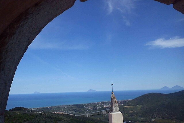
Фраццано (Frazzanò, Frazzanò)
.svg)
- коммуна в Италии
 Hiking in Фраццано
Frazzanò is a small town located in the province of Messina in Sicily, Italy. Surrounded by beautiful landscapes, it offers a variety of hiking opportunities for outdoor enthusiasts. Here are some key highlights and recommendations for hiking in and around Frazzanò:
Trails and Scenic Views
-
Natural Landscapes: The region is characterized by its stunning natural scenery, encompassing mountains, forests, and valleys. Popular hiking areas might include the nearby Nebrodi National Park, known for its diverse flora and fauna.
-
Local Trails: While specific marked trails may not be extensively documented, local residents can often provide insight into the best paths suited for hiking. It’s advisable to check in with local tourism offices or guide services for updated information on trails.
-
Panoramic Views: Many of the hikes in the area offer breathtaking views of the surrounding mountains and valleys, making it an excellent spot for photography and nature observation.
Preparation and Safety
-
Weather Considerations: The weather in Sicily can vary, so check forecasts before heading out. Spring and fall are often the best times to hike due to milder temperatures.
-
Gear: Proper hiking gear is essential. Comfortable footwear, appropriate clothing for the weather, and a daypack with essentials (water, snacks, first aid kit) are recommended.
-
Map and Navigation: Consider bringing a detailed map or a GPS device, especially if you venture into less-marked trails. Familiarize yourself with the area, particularly if you plan to trek alone.
Local Flora and Fauna
- The region features a variety of plant life, including Mediterranean shrubs and trees, and is home to various wildlife species. Keep an eye out for local birds and possibly some grazing livestock.
Conclusion
Hiking in Frazzanò can be a rewarding experience for those looking to connect with nature and explore the less-traveled paths of Sicily. Always prioritize safety, be prepared, and consider going with a guide if you're unfamiliar with the area. Enjoy your hiking adventure!
- Страна:

- Почтовый код: 98070
- Телефонный код: 0941
- Код автомобильного номера: ME
- Координаты: 38° 4' 0" N, 14° 45' 0" E


- GPS треки (wikiloc): [Ссылка]
- Высота над уровнем моря: 563 м m
- Площадь: 7 кв.км
- Население: 680
- Веб сайт: http://www.comunefrazzano.it/
- Википедия русская: wiki(ru)
- Википедия английская: wiki(en)
- Википедия национальная: wiki(it)
- Хранилище Wikidata: Wikidata: Q264835
- Катеория в википедии: [Ссылка]
- код Freebase: [/m/0gqcmc]
- код GeoNames: Альт: [6541332]
- код VIAF: Альт: [233891874]
- ID отношения в OpenStreetMap: [39504]
- код GND: Альт: [4679534-0]
- код TGN: [1044706]
- код ISTAT: 083026
- кадастровый код Италии: D793
Граничит с регионами:


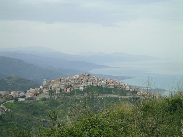
Сан-Сальваторе-ди-Фиталия
- коммуна в Италии
Hiking in Сан-Сальваторе-ди-Фиталия
San Salvatore di Fitalia is a charming village located in the Sicilian province of Messina, Italy. It offers a range of hiking opportunities that provide beautiful views of the surrounding natural landscape. Here are some highlights and tips for hiking in and around San Salvatore di Fitalia:...
- Страна:
- Почтовый код: 98070
- Телефонный код: 0941
- Код автомобильного номера: ME
- Координаты: 38° 4' 0" N, 14° 47' 0" E
- GPS треки (wikiloc): [Ссылка]
- Высота над уровнем моря: 603 м m
- Площадь: 15 кв.км
- Население: 1261
- Веб сайт: [Ссылка]


Галати-Мамертино
- коммуна в Италии
Hiking in Галати-Мамертино
Galati Mamertino is a small town located in the Nebrodi Mountains of Sicily, Italy. It offers a variety of hiking opportunities that cater to different levels of experience, from beginners to seasoned trekkers. Here are some key points about hiking in this picturesque area:...
- Страна:
- Почтовый код: 98070
- Телефонный код: 0941
- Код автомобильного номера: ME
- Координаты: 38° 2' 0" N, 14° 46' 0" E
- GPS треки (wikiloc): [Ссылка]
- Высота над уровнем моря: 820 м m
- Площадь: 39.31 кв.км
- Население: 2516
- Веб сайт: [Ссылка]

Капри-Леоне
- коммуна в Италии
Hiking in Капри-Леоне
Capri Leone, located in Sicily, Italy, offers a variety of hiking opportunities that showcase the region's beautiful landscapes, stunning coastal views, and rich natural heritage. Here are some key aspects of hiking in this area:...
- Страна:
- Почтовый код: 98070
- Телефонный код: 0941
- Код автомобильного номера: ME
- Координаты: 38° 5' 0" N, 14° 44' 0" E
- GPS треки (wikiloc): [Ссылка]
- Высота над уровнем моря: 420 м m
- Площадь: 6.76 кв.км
- Население: 4438
- Веб сайт: [Ссылка]
Лонджи
- коммуна в Италии
Hiking in Лонджи
Longi, which is located in the province of Módena in Italy, is known for its beautiful landscapes, charming villages, and rich culture, making it a fantastic destination for hiking enthusiasts. The region boasts a combination of rolling hills, vineyards, and forests, providing a variety of trails suitable for different skill levels....
- Страна:
- Почтовый код: 98070
- Телефонный код: 0941
- Код автомобильного номера: ME
- Координаты: 38° 2' 0" N, 14° 45' 0" E
- GPS треки (wikiloc): [Ссылка]
- Высота над уровнем моря: 616 м m
- Площадь: 42.11 кв.км
- Население: 1422
- Веб сайт: [Ссылка]


Мирто
- коммуна в Италии
Hiking in Мирто
Mirto is a charming village in the region of Sicily, Italy, known for its beautiful landscapes and rich cultural heritage. Hiking in and around Mirto provides opportunities to explore the stunning natural scenery, including mountains, vineyards, and coastal views....
- Страна:
- Почтовый код: 98070
- Телефонный код: 0941
- Код автомобильного номера: ME
- Координаты: 38° 5' 4" N, 14° 44' 46" E
- GPS треки (wikiloc): [Ссылка]
- Высота над уровнем моря: 428 м m
- Площадь: 9.27 кв.км
- Население: 953
- Веб сайт: [Ссылка]

Сан-Марко-д'Алунцио
- коммуна в Италии
Hiking in Сан-Марко-д'Алунцио
San Marco d'Alunzio is a charming hilltop town located in Sicily, Italy, known for its beautiful landscapes, historical architecture, and rich cultural heritage. Hiking in and around San Marco d'Alunzio offers various opportunities to explore the stunning natural scenery and enjoy the quaint atmosphere of the town....
- Страна:
- Почтовый код: 98070
- Телефонный код: 0941
- Код автомобильного номера: ME
- Координаты: 38° 4' 0" N, 14° 42' 0" E
- GPS треки (wikiloc): [Ссылка]
- Высота над уровнем моря: 548 м m
- Площадь: 26.14 кв.км
- Население: 1925
- Веб сайт: [Ссылка]