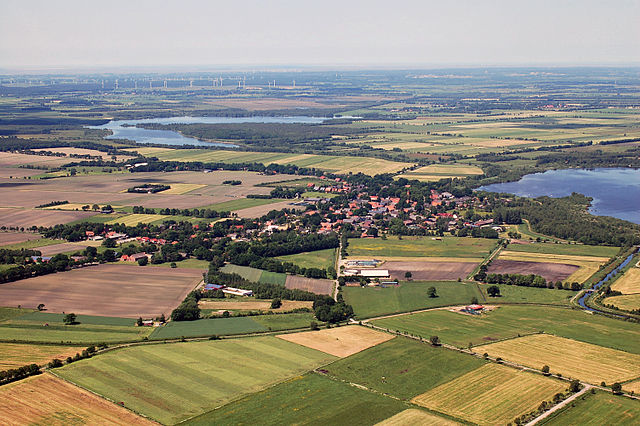
Гестланд (Geestland, Geestland)

 Hiking in Гестланд
Geestland is a picturesque region located in Lower Saxony, Germany, known for its unique landscapes and hiking opportunities. While the area may not be as popular as some of Germany’s more renowned hiking destinations, it offers peaceful trails and scenic views that are perfect for nature lovers and those seeking a quieter experience.
Hiking Opportunities in Geestland:
-
Natural Landscapes: Geestland features a mix of heathlands, forests, and agricultural landscapes. The varying terrain provides a diverse hiking experience where you can encounter different flora and fauna.
-
Trails: There are several well-marked hiking trails in and around Geestland. These trails are often suitable for different skill levels, ranging from easy walks to more challenging routes. It’s advisable to check local maps or resources for specific trails and their corresponding difficulty levels.
-
Nature Reserves: The region is home to several nature reserves where you can enjoy a day of hiking while taking in the beauty of the natural environment. Notable areas may include the surrounding heath and wetlands that are ideal for birdwatching and experiencing local wildlife.
-
Cultural Experience: As you hike, you may come across charming villages where you can learn about local culture and history. Stop in at small cafés or farms to enjoy local cuisine and hospitality.
-
Accessibility: Geestland is relatively accessible, and many trails are within close proximity to towns and urban areas. This makes it convenient for both day hikes and longer excursions.
Tips for Hiking in Geestland:
-
Weather: Check the weather forecast before heading out, as conditions can change rapidly, especially in the spring and fall. Dress in layers and be prepared for rain.
-
Footwear: Wear comfortable, sturdy hiking boots with good grip, as some trails may be uneven or muddy.
-
Hydration and Snacks: Bring plenty of water and some snacks, especially if you plan on hiking for several hours.
-
Local Maps: Utilize local hiking maps and guides, which can often be found at tourist information centers, to help navigate the trails.
-
Respect Nature: Stay on marked trails to preserve the natural environment, and remember to take all trash with you.
Whether you’re looking for a peaceful day hike or a chance to immerse yourself in nature, Geestland has something to offer for hikers of all levels. Enjoy your adventure!
- Страна:

- Почтовый код: 27624; 27607
- Телефонный код: 04765; 04756; 04745; 04743; 04742; 0471; 04708; 04707; 04704
- Код автомобильного номера: CUX
- Координаты: 53° 38' 0" N, 8° 45' 0" E


- GPS треки (wikiloc): [Ссылка]
- Высота над уровнем моря: 10 м m
- Площадь: 356.58 кв.км
- Население: 30873
- Веб сайт: https://www.geestland.eu/
- Википедия английская: wiki(en)
- Википедия национальная: wiki(de)
- Хранилище Wikidata: Wikidata: Q1497761
- Катеория в википедии: [Ссылка]
- ID отношения в OpenStreetMap: [4447298]
- ID отношения в OpenStreetMap: [4447298]
- ID отношения в OpenStreetMap: [4447298]
- код GND: Альт: [1075220246]
- код GND: Альт: [1075220246]
- код GND: Альт: [1075220246]
- идентификатор муниципалитетов в Германии: 03352062
- идентификатор муниципалитетов в Германии: 03352062
- идентификатор муниципалитетов в Германии: 03352062
Включает регионы:

Debstedt
Hiking in Debstedt
Debstedt, a small suburb of Bremerhaven in Germany, offers a unique hiking experience, primarily through its scenic landscapes and nearby natural areas. While it may not be known for extensive hiking trails like some national parks, there are still opportunities for enjoyable walks and hikes....
- Страна:
- Почтовый код: 27607
- Телефонный код: 04743
- Координаты: 53° 37' 20" N, 8° 38' 21" E
- GPS треки (wikiloc): [Ссылка]
- Высота над уровнем моря: 10 м m
- Площадь: 12.92 кв.км
Holßel
Hiking in Holßel
Holßel is a small village located in Lower Saxony, Germany, near the outskirts of larger urban areas and surrounded by natural beauty. While Holßel might not be widely known for extensive hiking trails like some larger national parks or mountainous regions, it does offer opportunities for outdoor activities and hiking in nearby natural areas....
- Страна:
- Почтовый код: 27607
- Телефонный код: 04742
- Координаты: 53° 41' 18" N, 8° 37' 8" E
- GPS треки (wikiloc): [Ссылка]
- Высота над уровнем моря: 10 м m
- Площадь: 19.85 кв.км
Hymendorf
Hiking in Hymendorf
Hymendorf is a small village in Germany, located in the Saxony region. While it may not be widely recognized as a hiking destination, the surrounding areas typically offer beautiful landscapes and opportunities for outdoor activities....
- Страна:
- Почтовый код: 27607
- Телефонный код: 04704
- Координаты: 53° 38' 26" N, 8° 42' 5" E
- GPS треки (wikiloc): [Ссылка]
- Высота над уровнем моря: 8 м m
- Площадь: 9.39 кв.км
Imsum
Hiking in Imsum
Imsum is a charming area in South Korea known for its beautiful landscapes and hiking opportunities. While not as widely recognized as some larger national parks, it offers a unique experience for hikers looking to explore nature away from the crowds. Here are some key points to consider when hiking in this region:...
- Страна:
- Почтовый код: 27607
- Телефонный код: 0471
- Координаты: 53° 36' 42" N, 8° 32' 13" E
- GPS треки (wikiloc): [Ссылка]
- Высота над уровнем моря: 3 м m
- Площадь: 9.46 кв.км
Neuenwalde
Hiking in Neuenwalde
Neuenwalde, located in the northern part of Germany near Bremerhaven, offers a variety of scenic trails and natural beauty that are perfect for hiking enthusiasts. The region is characterized by its picturesque landscapes, including forests, meadows, and wetland areas. Here are some aspects to consider when hiking in Neuenwalde:...
- Страна:
- Почтовый код: 27607
- Телефонный код: 04707
- Координаты: 53° 40' 40" N, 8° 40' 40" E
- GPS треки (wikiloc): [Ссылка]
- Высота над уровнем моря: 9 м m
- Площадь: 32.14 кв.км
Krempel
Hiking in Krempel
Krempel is a small village located in the district of Cuxhaven in Lower Saxony, Germany, within the Geestland region. While Krempel itself might not be a major hiking destination, the surrounding areas offer some pleasant opportunities for hiking, particularly in the lush landscapes of the Geestland region....
- Страна:
- Почтовый код: 27607
- Телефонный код: 04707
- Координаты: 53° 42' 31" N, 8° 42' 23" E
- GPS треки (wikiloc): [Ссылка]
- Высота над уровнем моря: 8 м m
- Площадь: 14.06 кв.км


Бад-Бедеркеза
Hiking in Бад-Бедеркеза
Bad Bederkesa is a charming town located in Lower Saxony, Germany, known for its scenic landscapes and outdoor activities, including hiking. The area offers a variety of trails that cater to different skill levels, making it an attractive destination for both casual walkers and more experienced hikers....
- Страна:
- Почтовый код: 27624
- Телефонный код: 04745
- Код автомобильного номера: CUX
- Координаты: 53° 37' 34" N, 8° 50' 34" E
- GPS треки (wikiloc): [Ссылка]
- Высота над уровнем моря: 9 м m
- Площадь: 43.17 кв.км
- Население: 5227
- Веб сайт: [Ссылка]


Линтиг
Hiking in Линтиг
Lintig, while not widely recognized in major hiking guides, is located in Lower Saxony, Germany, and can offer some charming hiking experiences due to its scenic countryside and natural surroundings. Here are a few tips and highlights for hiking in the region:...
- Страна:
- Почтовый код: 27624
- Код автомобильного номера: CUX
- Координаты: 53° 36' 12" N, 8° 52' 44" E
- GPS треки (wikiloc): [Ссылка]
- Высота над уровнем моря: 10 м m
- Площадь: 47.27 кв.км
- Веб сайт: [Ссылка]

Ланген
Hiking in Ланген
Langen, located in the district of Cuxhaven in Lower Saxony, Germany, offers some great opportunities for hiking and enjoying nature. While it may not be as well-known as some other hiking destinations in Germany, it provides a picturesque landscape and relatively easy access to both rural and coastal trails....
- Страна:
- Почтовый код: 27607
- Телефонный код: 04743
- Код автомобильного номера: CUX
- Координаты: 53° 37' 0" N, 8° 35' 0" E
- GPS треки (wikiloc): [Ссылка]
- Высота над уровнем моря: 14 м m
- Площадь: 121.60 кв.км
- Население: 18395
- Веб сайт: [Ссылка]
Кёлен
Hiking in Кёлен
Köhlen is a small municipality located in Lower Saxony, Germany. While it may not be as widely recognized for hiking as some of the more famous German landscapes, it offers opportunities for outdoor activities, particularly for those looking for tranquility and natural beauty....
- Страна:
- Почтовый код: 27624
- Телефонный код: 04708
- Код автомобильного номера: CUX
- Координаты: 53° 32' 28" N, 8° 52' 31" E
- GPS треки (wikiloc): [Ссылка]
- Высота над уровнем моря: 8 м m
- Площадь: 26.72 кв.км
- Веб сайт: [Ссылка]


Эльмлоэ
Hiking in Эльмлоэ
Elmlohe is a small village located in Lower Saxony, Germany. While it may not be a well-known hiking destination compared to larger national parks or mountainous regions, the area around Elmlohe offers a variety of scenic trails and outdoor experiences for hiking enthusiasts....
- Страна:
- Почтовый код: 27624
- Телефонный код: 04704
- Код автомобильного номера: CUX
- Координаты: 53° 35' 12" N, 8° 44' 33" E
- GPS треки (wikiloc): [Ссылка]
- Высота над уровнем моря: 5 м m
- Площадь: 23.30 кв.км


Рингштедт
Hiking in Рингштедт
Ringstedt is a small village located in Lower Saxony, Germany, and while it may not be as well-known for hiking as some other areas in Germany, it still offers opportunities for outdoor activities and walking in nature. Here’s what you should know about hiking in and around Ringstedt:...
- Страна:
- Почтовый код: 27624
- Телефонный код: 04708
- Код автомобильного номера: CUX
- Координаты: 53° 34' 0" N, 8° 51' 0" E
- GPS треки (wikiloc): [Ссылка]
- Высота над уровнем моря: 7 м m
- Площадь: 26.26 кв.км
- Веб сайт: [Ссылка]


Кюрштедт
Hiking in Кюрштедт
Kührstedt is a small village located in Lower Saxony, Germany, and is near the Lüneburg Heath (Lüneburger Heide), a popular hiking destination known for its stunning natural beauty, unique heath landscapes, and diverse flora and fauna. While Kührstedt itself may not be a well-known hiking hub, it can serve as a charming starting point for exploring the surrounding areas. Here are some highlights for hiking in and around Kührstedt:...
- Страна:
- Почтовый код: 27624
- Телефонный код: 04708
- Код автомобильного номера: CUX
- Координаты: 53° 34' 41" N, 8° 48' 5" E
- GPS треки (wikiloc): [Ссылка]
- Высота над уровнем моря: 5 м m
- Площадь: 25.50 кв.км
- Население: 1002
- Веб сайт: [Ссылка]
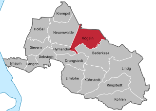
Флёгельн
Hiking in Флёгельн
Flögeln is a small village located in Lower Saxony, Germany. While it might not be as widely known as some other hiking destinations, it offers a peaceful environment and access to the beautiful countryside of the region. Hiking in and around Flögeln can provide a serene experience, with options to explore local trails, woods, and nature reserves....
- Страна:
- Почтовый код: 27624
- Телефонный код: 04745
- Код автомобильного номера: CUX
- Координаты: 53° 39' 35" N, 8° 48' 27" E
- GPS треки (wikiloc): [Ссылка]
- Высота над уровнем моря: 0 м m
- Площадь: 25.26 кв.км
- Веб сайт: [Ссылка]
Дрангштедт
Hiking in Дрангштедт
Drangstedt is a small village located in the Cuxhaven district of Lower Saxony, Germany. While it may not be a widely recognized hiking hotspot compared to larger national parks or famous trails, the surrounding area offers beautiful natural landscapes and opportunities for outdoor activities, including hiking....
- Страна:
- Почтовый код: 27624
- Телефонный код: 04704
- Координаты: 53° 37' 0" N, 8° 46' 0" E
- GPS треки (wikiloc): [Ссылка]
- Высота над уровнем моря: 32 м m
- Площадь: 17.02 кв.км
- Население: 1426
Граничит с регионами:
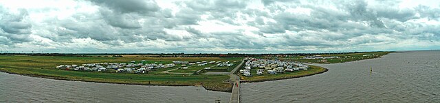

Wurster Nordseeküste
Hiking in Wurster Nordseeküste
Wurster Nordseeküste, located in Lower Saxony, Germany, is a beautiful coastal region along the North Sea. While it’s primarily known for its flat landscapes, sandy beaches, and charming villages, there are plenty of opportunities for hiking and outdoor activities in the area....
- Страна:
- Почтовый код: 27639
- Телефонный код: 04742; 04741; 04705
- Код автомобильного номера: CUX
- Координаты: 53° 47' 0" N, 8° 36' 0" E
- GPS треки (wikiloc): [Ссылка]
- Высота над уровнем моря: 21 м m
- Площадь: 182.08 кв.км
- Население: 17094
- Веб сайт: [Ссылка]