Джерминьяга (Germignaga, Germignaga)
.svg)
- коммуна Италии
 Hiking in Джерминьяга
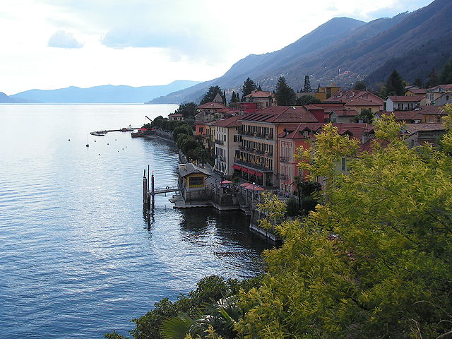
Germignaga is a picturesque village located on the shores of Lake Lugano in the Italian region of Lombardy. It is an excellent destination for hiking enthusiasts, offering a variety of trails that cater to different skill levels and interests. Here are some highlights of hiking in this beautiful area:
Trail Options:
-
Sentiero del Viandante: This is a popular hiking trail that runs along the eastern shore of Lake Como and provides stunning views of the lake and surrounding mountains. While it's not directly in Germignaga, it’s accessible from nearby towns and offers a chance to explore more of the region.
-
Monte Rognoso: A hike to Monte Rognoso offers a moderate challenge with rewarding panoramic views from the summit. The trail is surrounded by lush vegetation, and you might encounter local wildlife along the way.
-
Lakeside Walks: Germignaga has several scenic pathways along the lake, perfect for a leisurely hike or a nature walk. These trails often feature benches and viewpoints where you can take in the beauty of Lake Lugano.
-
Viggiù - Monte Sette Termini: A bit further afield, this trail offers a longer hike that leads you through wooded areas, charming villages, and up to viewpoints that allow for sweeping vistas of the surrounding landscape.
Tips for Hiking in Germignaga:
- Check the Weather: Mountain weather can change rapidly, so it's a good idea to check forecasts and be prepared for sudden changes.
- Footwear: Wear comfortable hiking shoes with good grip, especially for trails that can be rocky or uneven.
- Hydration and Snacks: Bring enough water and snacks, especially for longer hikes, as facilities may be limited on the trails.
- Safety: Familiarize yourself with the trail conditions and maps. If you are hiking solo, let someone know your plans.
Local Attractions:
- Cultural Sites: After your hike, explore the village itself, which features lovely architecture and local eateries serving traditional Italian cuisine.
- Water Activities: If time permits, consider kayaking or swimming in Lake Lugano to cool off after a day of hiking.
Getting There:
Germignaga is accessible by car and public transport from nearby towns. It is conveniently located near more extensive trail networks and other hiking towns, making it a great starting point for your outdoor adventures.
Whether you're looking for a challenging hike or a peaceful lakeside stroll, Germignaga offers a beautiful setting to enjoy nature and the stunning scenery of the region. Happy hiking!
- Страна:

- Почтовый код: 21010
- Телефонный код: 0332
- Код автомобильного номера: VA
- Координаты: 46° 0' 0" N, 8° 44' 0" E


- GPS треки (wikiloc): [Ссылка]
- Высота над уровнем моря: 204 м m
- Площадь: 4.66 кв.км
- Население: 3929
- Веб сайт: http://www.comune.germignaga.va.it/
- Википедия русская: wiki(ru)
- Википедия английская: wiki(en)
- Википедия национальная: wiki(it)
- Хранилище Wikidata: Wikidata: Q40900
- Катеория в википедии: [Ссылка]
- код Freebase: [/m/0ghz1c]
- код GeoNames: Альт: [6543091]
- ID отношения в OpenStreetMap: [46623]
- UN/LOCODE: [ITGNA]
- код ISTAT: 012076
- кадастровый код Италии: D987
Граничит с регионами:
Каннеро-Ривьера
- коммуна Италии
Hiking in Каннеро-Ривьера
Cannero Riviera, located on the western shore of Lake Maggiore in Italy's Piedmont region, is a picturesque destination that offers a variety of hiking opportunities amid stunning natural beauty. Here’s an overview of what you can expect when hiking in Cannero Riviera:...
- Страна:
- Почтовый код: 28021
- Телефонный код: 0323
- Код автомобильного номера: VB
- Координаты: 46° 1' 0" N, 8° 41' 0" E
- GPS треки (wikiloc): [Ссылка]
- Высота над уровнем моря: 212 м m
- Площадь: 14.42 кв.км
- Население: 916
- Веб сайт: [Ссылка]
Монтегрино-Вальтравалья
- коммуна Италии
Hiking in Монтегрино-Вальтравалья
Montegrino Valtravaglia is a picturesque commune in the province of Varese, Lombardy, Italy, nestled in the foothills of the Alps and close to Lake Lugano. It's a great destination for hiking enthusiasts who enjoy trails that offer stunning views of the surrounding nature, including the nearby mountains and lakes....
- Страна:
- Почтовый код: 21010
- Телефонный код: 0332
- Код автомобильного номера: VA
- Координаты: 45° 58' 29" N, 8° 46' 6" E
- GPS треки (wikiloc): [Ссылка]
- Высота над уровнем моря: 525 м m
- Площадь: 10.1 кв.км
- Население: 1478
- Веб сайт: [Ссылка]


Бреццо-ди-Бедеро
- коммуна Италии
Hiking in Бреццо-ди-Бедеро
Brezzo di Bedero is a charming village located in the province of Varese in the Lombardy region of Italy, situated on the western shore of Lake Maggiore. The area is known for its picturesque landscapes, lush forests, and panoramic views of the surrounding mountains and lake, making it an attractive destination for hikers....
- Страна:
- Почтовый код: 21010
- Телефонный код: 0332
- Код автомобильного номера: VA
- Координаты: 45° 59' 0" N, 8° 43' 0" E
- GPS треки (wikiloc): [Ссылка]
- Высота над уровнем моря: 352 м m
- Площадь: 9.95 кв.км
- Население: 1215
- Веб сайт: [Ссылка]


Луино
- коммуна Италии
Hiking in Луино
Luino is a charming town located on the eastern shore of Lake Maggiore in the Lombardy region of Italy. It offers a variety of hiking opportunities, thanks to its stunning natural scenery, including mountains, lakes, and forests. Here are a few notable aspects of hiking in and around Luino:...
- Страна:
- Почтовый код: 21016
- Телефонный код: 0332
- Код автомобильного номера: VA
- Координаты: 46° 0' 0" N, 8° 45' 0" E
- GPS треки (wikiloc): [Ссылка]
- Высота над уровнем моря: 202 м m
- Площадь: 21.01 кв.км
- Население: 14664
- Веб сайт: [Ссылка]
Бриссаго-Вальтравалья
- коммуна Италии
Hiking in Бриссаго-Вальтравалья
Brissago-Valtravaglia is a charming area located in the province of Varese, Lombardy, Italy. Nestled near the border with Switzerland, this region offers picturesque landscapes, stunning vistas, and many hiking opportunities for all levels of hikers. Here are some highlights about hiking in Brissago-Valtravaglia:...
- Страна:
- Почтовый код: 21030
- Телефонный код: 0332
- Код автомобильного номера: VA
- Координаты: 45° 57' 2" N, 8° 44' 25" E
- GPS треки (wikiloc): [Ссылка]
- Высота над уровнем моря: 429 м m
- Площадь: 6.12 кв.км
- Население: 1226
- Веб сайт: [Ссылка]