Grandvillars (Grandvillars)

- коммуна во Франции
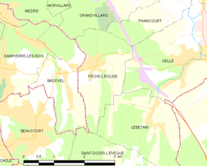
 Hiking in Grandvillars
Grandvillars, located in the Bourgogne-Franche-Comté region of France, offers a variety of scenic hiking opportunities, particularly for those who appreciate beautiful landscapes and natural surroundings. While the area is less known compared to major French hiking destinations, it still offers potential for enjoyable hikes in relatively serene environments. Here are some key points:
Trails and Surroundings
- Forests and Nature Reserves: The region is characterized by lush greenery, forests, and hills, making it suitable for various hiking trails that cater to different experience levels.
- Nearby Natural Attractions: Consider exploring nearby nature reserves or parks, which often have well-maintained trails and provide opportunities to see local wildlife.
Hiking Tips
- Trail Maps: Before heading out, make sure to obtain trail maps or download them from local hiking websites or apps. This will help you find marked routes and plan your hikes accordingly.
- Weather Considerations: Check the weather forecast before your hike, as conditions can change rapidly in natural environments, especially in wooded areas.
Access and Amenities
- Transportation: Depending on where you are starting from, you might consider local transportation options to reach trailheads, as some areas may not be directly accessible by public transport.
- Amenities: In the town itself or nearby, you may find local cafes or shops where you can stock up on supplies before your hike.
Safety Precautions
- Always inform someone about your hiking plans and estimated return time.
- Carry essentials like water, snacks, a first-aid kit, and a map or GPS device.
Conclusion
While Grandvillars might not be a mainstream hiking destination, it can provide a peaceful hiking experience amidst nature. Explore the area, enjoy the tranquility, and take advantage of the less crowded trails to connect with the outdoors. Happy hiking!
- Страна:

- Почтовый код: 90600
- Координаты: 47° 32' 20" N, 6° 58' 23" E


- GPS треки (wikiloc): [Ссылка]
- Площадь: 15.17 кв.км
- Население: 2975
- Веб сайт: http://www.grandvillars.fr
- Википедия английская: wiki(en)
- Википедия национальная: wiki(fr)
- Хранилище Wikidata: Wikidata: Q694344
- Катеория в википедии: [Ссылка]
- код Freebase: [/m/03mh9nv]
- код Freebase: [/m/03mh9nv]
- код GeoNames: Альт: [6451903]
- код GeoNames: Альт: [6451903]
- номер SIREN: [219000536]
- номер SIREN: [219000536]
- код BNF: [15279994g]
- код BNF: [15279994g]
- код VIAF: Альт: [240457784]
- код VIAF: Альт: [240457784]
- код тезауруса PACTOLS: [pcrtqvjSD19S56]
- код тезауруса PACTOLS: [pcrtqvjSD19S56]
- код муниципалитета INSEE: 90053
- код муниципалитета INSEE: 90053
Граничит с регионами:

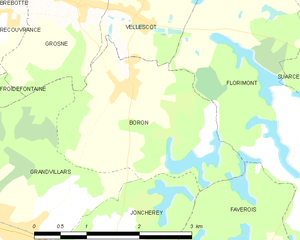
Boron
- коммуна во Франции
Hiking in Boron
Boron, located in the Territoire de Belfort region of France, offers a unique hiking experience amidst picturesque landscapes. The area is characterized by rolling hills, forests, and views of the nearby Belfort’s Lion, a famous landmark that commemorates the city’s history....
- Страна:
- Почтовый код: 90100
- Координаты: 47° 33' 40" N, 7° 0' 37" E
- GPS треки (wikiloc): [Ссылка]
- Площадь: 6.05 кв.км
- Население: 463


Froidefontaine
- коммуна во Франции
Hiking in Froidefontaine
Froidefontaine is a picturesque area located in the Vosges Mountains of northeastern France, known for its beautiful landscapes, rolling hills, and diverse wildlife. Hiking in this region offers a mix of scenic views, challenging terrain, and opportunities for both novice and experienced hikers....
- Страна:
- Почтовый код: 90140
- Координаты: 47° 33' 54" N, 6° 56' 51" E
- GPS треки (wikiloc): [Ссылка]
- Площадь: 4.55 кв.км
- Население: 451

Grosne
- коммуна во Франции
Hiking in Grosne
Grosne, a mountainous region situated in eastern France, offers a variety of hiking opportunities that cater to different skill levels and preferences. While there may be limited specific information directly linked to "Grosne," it’s often associated with the surrounding natural areas and parks known for their breathtaking landscapes, trails, and outdoor activities....
- Страна:
- Почтовый код: 90100
- Координаты: 47° 34' 29" N, 6° 59' 57" E
- GPS треки (wikiloc): [Ссылка]
- Площадь: 3.65 кв.км
- Население: 329

Badevel
- коммуна во Франции
Hiking in Badevel
Badevel, a charming area in the Doubs department of France, offers a variety of hiking opportunities for enthusiasts of all skill levels. The region is characterized by its picturesque landscapes, which include rolling hills, dense forests, and scenic viewpoints. Here are some key highlights for hiking in Badevel:...
- Страна:
- Почтовый код: 25490
- Координаты: 47° 30' 0" N, 6° 56' 23" E
- GPS треки (wikiloc): [Ссылка]
- Площадь: 3.73 кв.км
- Население: 833

Thiancourt
- коммуна во Франции
Hiking in Thiancourt
Thiancourt, a small village in France, is nestled in a picturesque region that offers a variety of hiking opportunities. While it may not be as widely known as some of the larger hiking destinations, it has its charm and scenic landscapes. Here are some key points to consider if you plan to hike in and around Thiancourt:...
- Страна:
- Почтовый код: 90100
- Координаты: 47° 31' 24" N, 6° 59' 25" E
- GPS треки (wikiloc): [Ссылка]
- Площадь: 2.67 кв.км
- Население: 302
Fêche-l'Église
- коммуна во Франции
Hiking in Fêche-l'Église
Fêche-l'Église is a charming commune located in the Doubs department of the Bourgogne-Franche-Comté region in eastern France. While it may not be as well-known as larger hiking destinations, it offers some beautiful landscapes and opportunities for outdoor enthusiasts looking to explore the serene French countryside....
- Страна:
- Почтовый код: 90100
- Координаты: 47° 30' 19" N, 6° 57' 6" E
- GPS треки (wikiloc): [Ссылка]
- Площадь: 3.93 кв.км
- Население: 792


Morvillars
- коммуна во Франции
Hiking in Morvillars
Morvillars is a small commune located in the Territoire de Belfort department in the Bourgogne-Franche-Comté region of eastern France. While it may not be a widely recognized hiking destination, it offers a charming rural landscape and can serve as a great base for exploring nearby natural areas....
- Страна:
- Почтовый код: 90120
- Координаты: 47° 32' 49" N, 6° 56' 0" E
- GPS треки (wikiloc): [Ссылка]
- Площадь: 5.27 кв.км
- Население: 1164


Joncherey
- коммуна во Франции
Hiking in Joncherey
Joncherey is a charming village located in the Grand Est region of France, near the borders of Switzerland and Germany. While it might not be as widely known as some other hiking destinations in the area, it offers opportunities for outdoor enthusiasts to explore the natural beauty of the surrounding region....
- Страна:
- Почтовый код: 90100
- Координаты: 47° 31' 44" N, 7° 0' 5" E
- GPS треки (wikiloc): [Ссылка]
- Площадь: 5.18 кв.км
- Население: 1305
- Веб сайт: [Ссылка]


Méziré
- коммуна во Франции
Hiking in Méziré
Méziré, a picturesque area in the Vosges region of France, offers a range of hiking opportunities that cater to different skill levels and interests. Here are some highlights and tips for hiking in Méziré:...
- Страна:
- Почтовый код: 90120
- Координаты: 47° 31' 52" N, 6° 55' 11" E
- GPS треки (wikiloc): [Ссылка]
- Площадь: 3.91 кв.км
- Население: 1372
- Веб сайт: [Ссылка]