Grange-de-Vaivre (Grange-de-Vaivre)

- коммуна во Франции
 Hiking in Grange-de-Vaivre
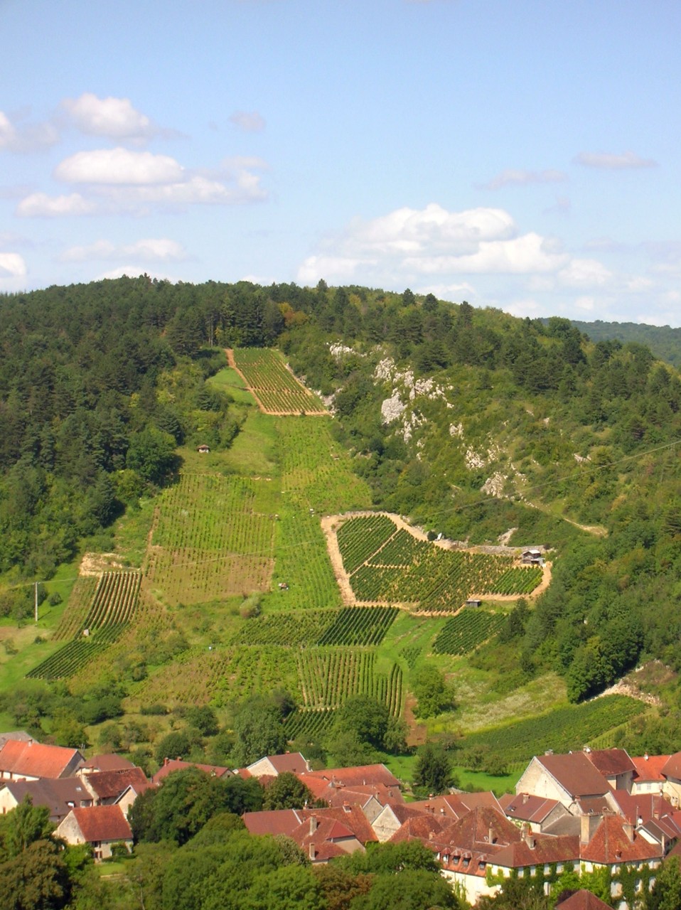
Grange-de-Vaivre is a natural area located near the city of Besançon in France, known for its scenic landscapes, rich flora, and varied hiking trails. Here are some key points to consider when hiking in this area:
Trail Options
-
Variety of Trails: The region offers a variety of hiking trails ranging from easy walks to more challenging hikes, suitable for different skill levels. These trails often wind through forests, hills, and along rivers.
-
Scenic Views: Many trails provide stunning views of the surrounding countryside, including vineyards and rolling hills, making it a picturesque hiking destination.
-
Loop Trails: Look for loop trails if you're interested in a circular hike that allows you to return to your starting point without retracing your steps.
Wildlife and Flora
- Biodiversity: The area is home to diverse wildlife, including birds and various plant species, making it a great spot for nature enthusiasts and bird watchers.
- Seasonal Beauty: Each season offers a unique experience, with wildflowers in spring, lush greenery in summer, vibrant autumn colors, and serene winter landscapes.
Preparation Tips
- Footwear: Wear sturdy hiking boots suitable for uneven terrain.
- Weather Check: Always check the weather forecast before heading out, as conditions can change rapidly.
- Hydration and Snacks: Carry enough water and snacks, especially if you plan on hiking longer trails.
Accessibility
- Starting Points: There are various access points to the trails, often with parking available nearby.
- Local Guides: Consider hiring a local guide if you're unfamiliar with the area, as they can provide valuable insights and ensure a safe experience.
Safety Tips
- Stay on Marked Trails: To avoid getting lost and to protect the natural environment, stick to marked trails.
- Inform Someone: Let someone know your hiking plans, including your expected return time.
Hiking in Grange-de-Vaivre can be a rewarding experience, so take your time to explore and appreciate the stunning natural beauty of the area!
- Страна:

- Почтовый код: 39600
- Координаты: 47° 0' 10" N, 5° 50' 27" E


- GPS треки (wikiloc): [Ссылка]
- Площадь: 1.74 кв.км
- Население: 39
- Википедия английская: wiki(en)
- Википедия национальная: wiki(fr)
- Хранилище Wikidata: Wikidata: Q321699
- Катеория в википедии: [Ссылка]
- код Freebase: [/m/03npjnn]
- код GeoNames: Альт: [6433576]
- номер SIREN: [213902596]
- код BNF: [152586224]
- код муниципалитета INSEE: 39259
Граничит с регионами:

Port-Lesney
- коммуна во Франции
Hiking in Port-Lesney
Port-Lesney, located in the Doubs department in the Bourgogne-Franche-Comté region of France, offers beautiful landscapes that are ideal for hiking enthusiasts. The region features lush forests, rolling hills, and the scenic banks of the Doubs River, providing a diverse range of hiking trails suitable for various skill levels....
- Страна:
- Почтовый код: 39600
- Координаты: 47° 0' 10" N, 5° 49' 26" E
- GPS треки (wikiloc): [Ссылка]
- Площадь: 10.91 кв.км
- Население: 539

Rennes-sur-Loue
- коммуна во Франции
Hiking in Rennes-sur-Loue
Rennes-sur-Loue is a picturesque village located in the Jura region of France, known for its stunning natural landscapes, hiking trails, and the scenic Loue River. Here are some key points to consider when hiking in and around Rennes-sur-Loue:...
- Страна:
- Почтовый код: 25440
- Координаты: 47° 0' 44" N, 5° 51' 10" E
- GPS треки (wikiloc): [Ссылка]
- Площадь: 5.5 кв.км
- Население: 95

Pagnoz
- коммуна во Франции
Hiking in Pagnoz
Pagnoz, located in the scenic region of the Swiss Alps, offers a variety of hiking opportunities for enthusiasts of all levels. The area is known for its stunning landscapes, including lush valleys, rugged mountains, and picturesque lakes....
- Страна:
- Почтовый код: 39330
- Координаты: 46° 58' 4" N, 5° 49' 12" E
- GPS треки (wikiloc): [Ссылка]
- Площадь: 3.29 кв.км
- Население: 232


La Chapelle-sur-Furieuse
- коммуна во Франции
Hiking in La Chapelle-sur-Furieuse
La Chapelle-sur-Furieuse is a picturesque village situated in the Doubs department of France, nestled in the Jura Mountains. It’s a great location for hiking enthusiasts looking to explore the beautiful natural landscapes of this region. Here’s what you can expect when hiking around La Chapelle-sur-Furieuse:...
- Страна:
- Почтовый код: 39110
- Координаты: 46° 59' 52" N, 5° 51' 27" E
- GPS треки (wikiloc): [Ссылка]
- Площадь: 9.03 кв.км
- Население: 322