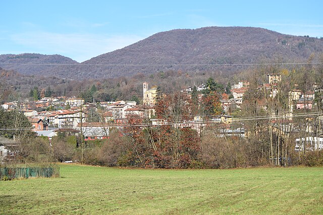
Грантола (Grantola, Grantola)
.svg)
- коммуна Италии
 Hiking in Грантола
Grantola is a picturesque area located in the province of Varese, Lombardy, Italy, nestled in the foothills of the Alps and near the shores of Lake Lugano. It's a beautiful destination for hiking enthusiasts, offering various trails that showcase the stunning natural landscape.
Hiking Trails and Opportunities:
-
Natural Scenery: The hiking trails around Grantola offer breathtaking views of the surrounding mountains, forests, and lakes. Make sure to pack a camera to capture the scenic panoramas.
-
Trail Options:
- Easy to Moderate Trails: Many trails are suited for walkers of all levels, ranging from easy strolls to more moderate hikes. These trails often wind through lush forests and meadows.
- Specific Trails:
- Trails leading to Monte Crenna provide panoramic views of Lake Lugano and the surrounding areas.
- The Sentiero dei Fiori, or Flower Trail, is known for its rich flora, and it’s perfect for nature lovers.
-
Wildlife Watching: The region is home to various species of flora and fauna. Keep an eye out for some unique wildlife, particularly birds and small mammals.
-
Cultural Aspects: Some hikes will also take you past historical villages, churches, and local farms, providing a blend of outdoor activity and cultural exploration.
Practical Tips:
-
Best Season for Hiking: Spring and early fall are ideal for hiking in Grantola, as the weather is typically mild, and the trails are less crowded than in summer.
-
Gear Recommendations: Wear sturdy hiking boots, and bring plenty of water, snacks, and a good map or GPS device. It’s also advisable to check the weather forecast before setting out.
-
Local Regulations: Be mindful of local regulations regarding trail use, and stay on marked paths to protect the natural environment.
-
Local Guidance: If you're new to hiking or the area, consider joining a guided hike with a local instructor who can provide insights into the terrain and safety tips.
Nearby Attractions:
After your hike, you might want to explore Lake Lugano or visit the nearby towns of Luino or Porto Ceresio, both of which offer lovely lakeside views and charming shops and restaurants.
Enjoy your hiking adventure in Grantola, surrounded by the stunning natural beauty of Northern Italy!
- Страна:

- Почтовый код: 21030
- Телефонный код: 0332
- Код автомобильного номера: VA
- Координаты: 45° 57' 0" N, 8° 47' 0" E


- GPS треки (wikiloc): [Ссылка]
- Высота над уровнем моря: 250 м m
- Площадь: 2.05 кв.км
- Население: 1288
- Веб сайт: http://www.comune.grantola.va.it/
- Википедия русская: wiki(ru)
- Википедия английская: wiki(en)
- Википедия национальная: wiki(it)
- Хранилище Wikidata: Wikidata: Q39801
- Катеория в википедии: [Ссылка]
- код Freebase: [/m/0ghz4l]
- код GeoNames: Альт: [6543092]
- ID отношения в OpenStreetMap: [46552]
- UN/LOCODE: [ITZJR]
- код ISTAT: 012081
- кадастровый код Италии: E144
Граничит с регионами:
Монтегрино-Вальтравалья
- коммуна Италии
Hiking in Монтегрино-Вальтравалья
Montegrino Valtravaglia is a picturesque commune in the province of Varese, Lombardy, Italy, nestled in the foothills of the Alps and close to Lake Lugano. It's a great destination for hiking enthusiasts who enjoy trails that offer stunning views of the surrounding nature, including the nearby mountains and lakes....
- Страна:
- Почтовый код: 21010
- Телефонный код: 0332
- Код автомобильного номера: VA
- Координаты: 45° 58' 29" N, 8° 46' 6" E
- GPS треки (wikiloc): [Ссылка]
- Высота над уровнем моря: 525 м m
- Площадь: 10.1 кв.км
- Население: 1478
- Веб сайт: [Ссылка]

Кунардо
- коммуна Италии
Hiking in Кунардо
Cunardo, located in the province of Varese in Lombardy, Italy, is surrounded by beautiful natural landscapes, making it a great destination for hiking enthusiasts. The area is characterized by mountainous terrain, lush forests, and scenic views of the surrounding valleys and lakes....
- Страна:
- Почтовый код: 21035
- Телефонный код: 0332
- Код автомобильного номера: VA
- Координаты: 45° 56' 0" N, 8° 48' 0" E
- GPS треки (wikiloc): [Ссылка]
- Высота над уровнем моря: 450 м m
- Площадь: 6.06 кв.км
- Население: 2969
- Веб сайт: [Ссылка]
Кульяте-Фабьаско
- коммуна Италии
Hiking in Кульяте-Фабьаско
Cugliate-Fabiasco is a charming municipality located in the province of Varese in the Lombardy region of Italy. It is situated in the foothills of the Alps and offers a variety of hiking opportunities that showcase the stunning landscape of the area....
- Страна:
- Почтовый код: 21030
- Телефонный код: 0332
- Код автомобильного номера: VA
- Координаты: 45° 56' 52" N, 8° 49' 18" E
- GPS треки (wikiloc): [Ссылка]
- Высота над уровнем моря: 516 м m
- Площадь: 6.54 кв.км
- Население: 3121
- Веб сайт: [Ссылка]
Мезенцана
- коммуна Италии
Hiking in Мезенцана
Mesenzana is a charming municipality located in the province of Varese, Lombardy, Italy. Nestled in the foothills of the Alps and near the shores of Lake Maggiore, it offers stunning natural scenery and various hiking opportunities....
- Страна:
- Почтовый код: 21030
- Телефонный код: 0332
- Код автомобильного номера: VA
- Координаты: 45° 56' 49" N, 8° 45' 32" E
- GPS треки (wikiloc): [Ссылка]
- Высота над уровнем моря: 305 м m
- Площадь: 4.88 кв.км
- Население: 1534
- Веб сайт: [Ссылка]


Феррера-ди-Варезе
- коммуна Италии
Hiking in Феррера-ди-Варезе
Ferrera di Varese is a charming municipality located in the province of Varese in the Lombardy region of northern Italy. The area is particularly known for its beautiful natural landscapes, making it a great destination for hiking enthusiasts....
- Страна:
- Почтовый код: 21030
- Телефонный код: 0332
- Код автомобильного номера: VA
- Координаты: 45° 56' 0" N, 8° 47' 0" E
- GPS треки (wikiloc): [Ссылка]
- Высота над уровнем моря: 299 м m
- Площадь: 1.53 кв.км
- Население: 703
- Веб сайт: [Ссылка]
Кассано-Валькувия
- коммуна Италии
Hiking in Кассано-Валькувия
Cassano Valcuvia is a charming town located in the province of Varese in the Lombardy region of Italy. Nestled in the foothills of the Alps, it offers a variety of hiking opportunities that are perfect for outdoor enthusiasts of all skill levels. Here’s what you can expect when hiking in Cassano Valcuvia:...
- Страна:
- Почтовый код: 21030
- Телефонный код: 0332
- Код автомобильного номера: VA
- Координаты: 45° 56' 0" N, 8° 46' 0" E
- GPS треки (wikiloc): [Ссылка]
- Высота над уровнем моря: 296 м m
- Площадь: 3.95 кв.км
- Население: 675
- Веб сайт: [Ссылка]