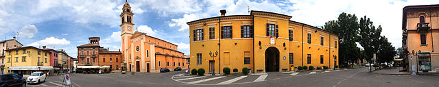
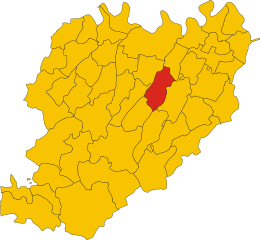
Гроппарелло (Gropparello, Gropparello)
.svg)
- коммуна Италии
 Hiking in Гроппарелло
Gropparello is a picturesque area located in the Emilia-Romagna region of Italy, known for its beautiful landscapes, historical sites, and outdoor activities, including hiking. The surroundings are characterized by rolling hills, dense forests, and stunning views, making it an ideal spot for nature lovers and hiking enthusiasts.
Hiking Trails
-
Sentiero della Rocca: This trail leads you to the historical Gropparello Castle, providing both a scenic hike and a chance to explore the castle's fascinating history. The trail is well-marked and suitable for various fitness levels.
-
Parco dell'Antola: This nearby park offers a network of trails that wind through diverse natural environments, featuring rich flora and fauna. The trails range from easy walks to more challenging hikes, suitable for families and experienced hikers alike.
-
The Via dei Parchi: A longer hike that connects various parks in the region, offering a mix of terrains, from forest paths to scenic overlooks. This trail provides a chance to immerse yourself in the region's natural beauty.
Things to Keep in Mind
- Best Time to Visit: Spring and autumn are ideal for hiking in Gropparello, as temperatures are mild and the scenery is particularly beautiful during these seasons.
- Preparation: Always check the weather forecast before heading out, wear appropriate hiking gear, and take sufficient water and snacks.
- Guided Tours: If you're unfamiliar with the area, consider joining a guided hiking tour to learn more about the local history and environment while ensuring you don't get lost on the trails.
Additional Activities
Apart from hiking, Gropparello offers opportunities for exploring its historical attractions, visiting local farms, and enjoying traditional Emilia-Romagna cuisine. There are also biking trails for those who may wish to explore the area on two wheels.
Conclusion
Hiking in Gropparello offers a blend of natural beauty, cultural history, and outdoor adventure. Whether you are a casual walker or an experienced hiker, you'll find trails that cater to your needs and provide stunning views of this enchanting part of Italy.
- Страна:

- Почтовый код: 29025
- Телефонный код: 0523
- Код автомобильного номера: PC
- Координаты: 44° 50' 0" N, 9° 44' 0" E


- GPS треки (wikiloc): [Ссылка]
- Высота над уровнем моря: 355 м m
- Площадь: 56.33 кв.км
- Население: 2268
- Веб сайт: http://www.comune.gropparello.pc.it
- Википедия русская: wiki(ru)
- Википедия английская: wiki(en)
- Википедия национальная: wiki(it)
- Хранилище Wikidata: Wikidata: Q102784
- Катеория в википедии: [Ссылка]
- код Freebase: [/m/0gkcx3]
- код GeoNames: Альт: [6541829]
- ID отношения в OpenStreetMap: [43603]
- WOEID: [716419]
- UN/LOCODE: [ITGPP]
- код ISTAT: 033025
- кадастровый код Италии: E196
Граничит с регионами:


Беттола
- коммуна Италии
Hiking in Беттола
Bettola is a charming town located in the Emilia-Romagna region of Italy, surrounded by beautiful landscapes that make it a great destination for hiking enthusiasts. Here are some highlights and tips for hiking in and around Bettola:...
- Страна:
- Почтовый код: 29021
- Телефонный код: 0523
- Код автомобильного номера: PC
- Координаты: 44° 46' 42" N, 9° 36' 31" E
- GPS треки (wikiloc): [Ссылка]
- Высота над уровнем моря: 329 м m
- Площадь: 122.37 кв.км
- Население: 2759
- Веб сайт: [Ссылка]

Карпането-Пьачентино
- коммуна Италии
Hiking in Карпането-Пьачентино
Carpaneto Piacentino is a charming town located in the Piacenza province of Emilia-Romagna, Italy. It is surrounded by beautiful landscapes, rolling hills, and vineyards, making it a delightful destination for hiking enthusiasts. Here are some highlights to consider if you're planning a hiking trip in and around Carpaneto Piacentino:...
- Страна:
- Почтовый код: 29013
- Телефонный код: 0523
- Код автомобильного номера: PC
- Координаты: 44° 55' 0" N, 9° 47' 0" E
- GPS треки (wikiloc): [Ссылка]
- Высота над уровнем моря: 400 м m
- Площадь: 63.08 кв.км
- Население: 7733
- Веб сайт: [Ссылка]


Луганьяно-Валь-д'Арда
- коммуна Италии
Hiking in Луганьяно-Валь-д'Арда
Lugagnano Val d'Arda is a charming village located in the Piacenza province of Emilia-Romagna, Italy. The surrounding area offers a mix of scenic landscapes, rolling hills, and rural charm, making it an attractive destination for hiking enthusiasts. Here are some highlights and tips for hiking in this area:...
- Страна:
- Почтовый код: 29018
- Телефонный код: 0523
- Код автомобильного номера: PC
- Координаты: 44° 49' 0" N, 9° 49' 0" E
- GPS треки (wikiloc): [Ссылка]
- Высота над уровнем моря: 229 м m
- Площадь: 54.4 кв.км
- Население: 3976
- Веб сайт: [Ссылка]
Морфассо
- коммуна Италии
Hiking in Морфассо
Morfasso is a charming village located in the Emilia-Romagna region of Italy, surrounded by picturesque landscapes, forests, and hills. It’s an excellent destination for hiking enthusiasts, offering a variety of trails that cater to different skill levels, from leisurely walks to more challenging treks....
- Страна:
- Почтовый код: 29020
- Телефонный код: 0523
- Код автомобильного номера: PC
- Координаты: 44° 43' 0" N, 9° 42' 0" E
- GPS треки (wikiloc): [Ссылка]
- Высота над уровнем моря: 631 м m
- Площадь: 83.93 кв.км
- Население: 972
- Веб сайт: [Ссылка]


Понте-делл'Олио
- коммуна Италии
Hiking in Понте-делл'Олио
Ponte dell'Olio is a charming village located in the province of Piacenza, in the Emilia-Romagna region of Italy. Known for its scenic landscapes and rolling hills, it offers various hiking opportunities that cater to different skill levels....
- Страна:
- Почтовый код: 29028
- Телефонный код: 0523
- Код автомобильного номера: PC
- Координаты: 44° 52' 0" N, 9° 38' 0" E
- GPS треки (wikiloc): [Ссылка]
- Высота над уровнем моря: 217 м m
- Площадь: 43.92 кв.км
- Население: 4691
- Веб сайт: [Ссылка]

Сан-Джорджо-Пьячентино
- коммуна Италии
Hiking in Сан-Джорджо-Пьячентино
San Giorgio Piacentino is a quaint municipality located in the Emilia-Romagna region of Italy, known for its beautiful landscapes, rolling hills, and rich agricultural heritage. While it may not be a major hiking destination compared to larger national parks or mountainous regions, it offers several opportunities for outdoor enthusiasts to enjoy hiking in a serene and picturesque environment....
- Страна:
- Почтовый код: 29019
- Телефонный код: 0523
- Код автомобильного номера: PC
- Координаты: 44° 57' 0" N, 9° 44' 0" E
- GPS треки (wikiloc): [Ссылка]
- Высота над уровнем моря: 103 м m
- Площадь: 49.19 кв.км
- Население: 5673
- Веб сайт: [Ссылка]