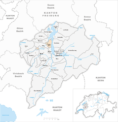
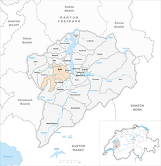
Грюйер (Gruyère District, Greyerzbezirk)

 Hiking in Грюйер
The Gruyère District, located in the Canton of Fribourg in Switzerland, is a fantastic destination for hiking enthusiasts. Known for its stunning landscapes, picturesque villages, and rich cultural heritage, Gruyère offers a variety of trails that cater to different skill levels and preferences.
Key Features of Hiking in Gruyère:
-
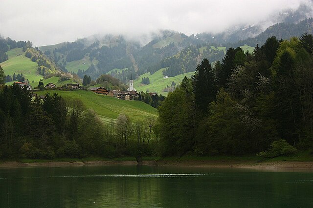
Scenic Trails: The region is characterized by lush green pastures, rolling hills, and the backdrop of the impressive Alps. The trails often provide panoramic views of the surrounding mountains and valleys, making it a delight for photographers and nature lovers.
-
Variety of Routes: There are numerous well-marked hiking trails in Gruyère, ranging from easy walks to challenging hikes. Some popular routes include:
- The Gruyères Trail: This hike takes you through the region's enchanting landscapes and charming villages, including the famous medieval town of Gruyères, known for its cheese.
- The Mount Cohend Trail: For those looking for a more strenuous hike, this trail offers an uphill climb with rewarding views from the summit.
-
Historical Sites: While hiking, you can explore historical landmarks such as the Gruyères Castle, cheesemaking farms, and ancient chapels, enriching your hiking experience with cultural insights.
-
Wildlife and Nature: The region is home to diverse flora and fauna, giving hikers a chance to observe local wildlife in their natural habitats. Keep an eye out for various bird species, deer, and unique alpine plants.
-
Gastronomy: After a long day of hiking, indulge in the local cuisine. Gruyères is famous for its cheese, and you can enjoy traditional dishes like fondue at local restaurants or mountain huts.
-
Accessibility: The region is easily accessible by public transport, making it convenient for day trips or extended stays. Many trails are also connected to cable cars or funiculars that can help you gain altitude quickly.
Tips for Hiking in Gruyère:
- Check the Weather: Weather can change rapidly in the mountains, so be sure to check conditions before heading out.
- Proper Gear: Wear appropriate hiking footwear and clothing. Bring plenty of water, snacks, and a first-aid kit for longer hikes.
- Trail Etiquette: Follow marked trails and respect nature. Keep noise levels down and ensure you leave no trace.
- Maps and Guides: Consider using detailed hiking maps or local guides for the best experience and to discover hidden gems along the way.
Whether you’re a seasoned hiker or a beginner, the Gruyère District has something to offer everyone looking to experience the beauty of the Swiss Alps. Enjoy your adventures in this enchanting region!
- Страна:

- Столица: Бюль
- Код автомобильного номера: FR
- Координаты: 46° 36' 27" N, 7° 6' 26" E


- GPS треки (wikiloc): [Ссылка]
- Высота над уровнем моря: 683 м m
- Площадь: 489.4 кв.км
- Веб сайт: http://www.fr.ch/prgr
- Википедия русская: wiki(ru)
- Википедия английская: wiki(en)
- Википедия национальная: wiki(de)
- Хранилище Wikidata: Wikidata: Q388306
- Катеория в википедии: [Ссылка]
- код Freebase: [/m/09bx00]
- код GeoNames: Альт: [6458796]
- ID отношения в OpenStreetMap: [1698883]
- код GND: Альт: [4314814-1]
- код в энциклопедии «Британника онлайн»: [place/La-Gruyere]
- идентификатор HDS: [8148]
Включает регионы:


Bas-Intyamon
Hiking in Bas-Intyamon
Bas-Intyamon is a beautiful area located in the canton of Fribourg, Switzerland. It's characterized by rolling hills, lush forests, and stunning alpine scenery, making it a fantastic destination for hiking enthusiasts. Here are some key points about hiking in Bas-Intyamon:...
- Страна:
- Телефонный код: 026
- Код автомобильного номера: FR
- Координаты: 46° 34' 0" N, 7° 5' 0" E
- GPS треки (wikiloc): [Ссылка]
- Высота над уровнем моря: 720 м m
- Площадь: 33.27 кв.км
- Население: 1387
- Веб сайт: [Ссылка]


Hauteville
Hiking in Hauteville
Hauteville, located in the beautiful region of Switzerland, offers stunning hiking opportunities amid the majestic Alps. When hiking in this area, you'll encounter a mix of well-marked trails that cater to various skill levels, allowing both novice and experienced hikers to enjoy the breathtaking scenery....
- Страна:
- Почтовый код: 1648
- Телефонный код: 026
- Код автомобильного номера: FR
- Координаты: 46° 40' 7" N, 7° 8' 3" E
- GPS треки (wikiloc): [Ссылка]
- Высота над уровнем моря: 1041 м m
- Площадь: 10.56 кв.км
- Население: 652
- Веб сайт: [Ссылка]


Vaulruz
Hiking in Vaulruz
Vaulruz, a charming village located in the canton of Fribourg in Switzerland, offers a picturesque setting for hikers looking to explore the scenic Swiss countryside. Nestled between rolling hills and lush forests, Vaulruz provides a variety of trails to suit different fitness levels and preferences....
- Страна:
- Почтовый код: 1627
- Телефонный код: 026
- Код автомобильного номера: FR
- Координаты: 46° 37' 0" N, 6° 59' 0" E
- GPS треки (wikiloc): [Ссылка]
- Высота над уровнем моря: 820 м m
- Площадь: 10.09 кв.км
- Население: 1060
- Веб сайт: [Ссылка]
Sorens
Hiking in Sorens
Sorens is a picturesque municipality located in the Fribourg region of Switzerland, known for its stunning natural landscapes and outdoor activities, including hiking. The area is characterized by rolling hills, lush forests, and beautiful views of the surrounding countryside, making it an excellent destination for hikers of all levels....
- Страна:
- Почтовый код: 1642
- Телефонный код: 026
- Код автомобильного номера: FR
- Координаты: 46° 40' 0" N, 7° 4' 0" E
- GPS треки (wikiloc): [Ссылка]
- Высота над уровнем моря: 800 м m
- Площадь: 8.74 кв.км
- Население: 1087
- Веб сайт: [Ссылка]


Vuadens
Hiking in Vuadens
Vuadens is a charming village located in the canton of Fribourg, Switzerland. It is surrounded by beautiful natural landscapes, making it a great destination for hiking enthusiasts. Here are some highlights you might find interesting:...
- Страна:
- Почтовый код: 1628
- Телефонный код: 026
- Код автомобильного номера: FR
- Координаты: 46° 37' 0" N, 7° 1' 0" E
- GPS треки (wikiloc): [Ссылка]
- Высота над уровнем моря: 803 м m
- Площадь: 10.49 кв.км
- Население: 2317
- Веб сайт: [Ссылка]

Echarlens
Hiking in Echarlens
Echarlens, a picturesque village located in the fribourg region of Switzerland, offers some lovely hiking opportunities, particularly for those who appreciate stunning Alpine scenery and a quieter, less-crowded experience than some of the more famous hiking destinations in Switzerland....
- Страна:
- Почтовый код: 1646
- Телефонный код: 026
- Код автомобильного номера: FR
- Координаты: 46° 38' 45" N, 7° 4' 38" E
- GPS треки (wikiloc): [Ссылка]
- Высота над уровнем моря: 721 м m
- Площадь: 4.61 кв.км
- Население: 804
- Веб сайт: [Ссылка]


Haut-Intyamon
Hiking in Haut-Intyamon
Haut-Intyamon is a scenic area located in the canton of Fribourg, Switzerland. It's known for its beautiful landscapes, charming villages, and a variety of hiking trails suitable for different skill levels. Here are some highlights and tips for hiking in Haut-Intyamon:...
- Страна:
- Почтовый код: 1669
- Телефонный код: 026
- Код автомобильного номера: FR
- Координаты: 46° 31' 1" N, 7° 3' 22" E
- GPS треки (wikiloc): [Ссылка]
- Высота над уровнем моря: 763 м m
- Площадь: 60.44 кв.км
- Население: 1542
- Веб сайт: [Ссылка]


Grandvillard
Hiking in Grandvillard
Grandvillard is a picturesque village located in the Gruyère region of Switzerland, known for its stunning natural landscapes, rich cultural history, and varied hiking trails. Hiking in this area can be a rewarding experience, as you can enjoy breathtaking views of the Swiss Alps, lush meadows, and serene lakes. Here are some key points to consider for hiking in Grandvillard:...
- Страна:
- Почтовый код: 1666
- Телефонный код: 026
- Код автомобильного номера: FR
- Координаты: 46° 32' 0" N, 7° 5' 0" E
- GPS треки (wikiloc): [Ссылка]
- Высота над уровнем моря: 762 м m
- Площадь: 24.22 кв.км
- Население: 830
- Веб сайт: [Ссылка]


Pont-en-Ogoz
Hiking in Pont-en-Ogoz
Pont-en-Ogoz, located in the Canton of Fribourg in Switzerland, is a picturesque area known for its stunning landscapes and outdoor activities, making it a great destination for hiking enthusiasts. Here are some key points to consider about hiking in this region:...
- Страна:
- Почтовый код: 1643, 1644, 1645
- Телефонный код: 026
- Код автомобильного номера: FR
- Координаты: 46° 41' 0" N, 7° 5' 0" E
- GPS треки (wikiloc): [Ссылка]
- Высота над уровнем моря: 726 м m
- Площадь: 9.95 кв.км
- Население: 1807
- Веб сайт: [Ссылка]


Jaun
Hiking in Jaun
Jaun is a picturesque village located in the Fribourg region of Switzerland, surrounded by stunning landscapes and offering a range of hiking opportunities. Here are some highlights and tips for hiking in and around Jaun:...
- Страна:
- Почтовый код: 1656
- Телефонный код: 026
- Код автомобильного номера: FR
- Координаты: 46° 37' 0" N, 7° 16' 0" E
- GPS треки (wikiloc): [Ссылка]
- Высота над уровнем моря: 1015 м m
- Площадь: 55.24 кв.км
- Население: 659
- Веб сайт: [Ссылка]


Марсан
Hiking in Марсан
Marsens is a charming village located in the Fribourg region of Switzerland, perched on the edge of the Saane River valley. It offers a delightful setting for hiking, with beautiful landscapes, lush forests, and picturesque views of the surrounding mountains....
- Страна:
- Почтовый код: 1633
- Телефонный код: 026
- Код автомобильного номера: FR
- Координаты: 46° 39' 0" N, 7° 4' 0" E
- GPS треки (wikiloc): [Ссылка]
- Высота над уровнем моря: 722 м m
- Площадь: 7.79 кв.км
- Население: 1913
- Веб сайт: [Ссылка]
Morlon
Hiking in Morlon
Morlon, located in the Fribourg region of Switzerland, is a beautiful destination for hiking enthusiasts. Nestled in the foothills of the Swiss Alps, Morlon offers a variety of trails that cater to different skill levels, making it suitable for both beginners and experienced hikers....
- Страна:
- Почтовый код: 1638
- Телефонный код: 026
- Код автомобильного номера: FR
- Координаты: 46° 38' 0" N, 7° 5' 0" E
- GPS треки (wikiloc): [Ссылка]
- Высота над уровнем моря: 751 м m
- Площадь: 2.50 кв.км
- Население: 595
- Веб сайт: [Ссылка]
Botterens
Hiking in Botterens
Botterens, located in the Swiss region of Fribourg, offers a beautiful backdrop for hiking enthusiasts. The area features lush landscapes, rolling hills, and stunning views of the Alps....
- Страна:
- Телефонный код: 026
- Код автомобильного номера: FR
- Координаты: 46° 37' 0" N, 7° 7' 0" E
- GPS треки (wikiloc): [Ссылка]
- Высота над уровнем моря: 744 м m
- Площадь: 4.15 кв.км
- Население: 568
- Веб сайт: [Ссылка]


Шармей
Hiking in Шармей
Charmey, located in the scenic region of Gruyères in Switzerland, is an excellent destination for hiking enthusiasts. Nestled in the Pre-Alps, it offers a variety of trails that cater to different skill levels, making it suitable for both beginners and experienced hikers....
- Страна:
- Почтовый код: 1637
- Телефонный код: 026
- Код автомобильного номера: FR
- Координаты: 46° 37' 0" N, 7° 10' 0" E
- GPS треки (wikiloc): [Ссылка]
- Высота над уровнем моря: 887 м m
- Площадь: 78.44 кв.км
- Веб сайт: [Ссылка]

Crésuz
Hiking in Crésuz
Crésuz, located in the beautiful region of the Swiss Alps, offers a variety of hiking opportunities amidst stunning natural scenery. Here are some key points to keep in mind when planning a hike in Crésuz:...
- Страна:
- Почтовый код: 1653
- Телефонный код: 026
- Код автомобильного номера: FR
- Координаты: 46° 37' 0" N, 7° 8' 0" E
- GPS треки (wikiloc): [Ссылка]
- Высота над уровнем моря: 909 м m
- Площадь: 1.80 кв.км
- Население: 342
- Веб сайт: [Ссылка]
Pont-la-Ville
Hiking in Pont-la-Ville
Pont-la-Ville, located in the district of Broye in the canton of Fribourg, Switzerland, offers a range of hiking opportunities suitable for different fitness levels and experiences. The picturesque landscape features rolling hills, lush green meadows, and beautiful views of the surrounding mountains, making it a great destination for nature enthusiasts....
- Страна:
- Почтовый код: 1649
- Телефонный код: 026
- Код автомобильного номера: FR
- Координаты: 46° 42' 0" N, 7° 7' 0" E
- GPS треки (wikiloc): [Ссылка]
- Высота над уровнем моря: 746 м m
- Площадь: 4.33 кв.км
- Население: 599
- Веб сайт: [Ссылка]
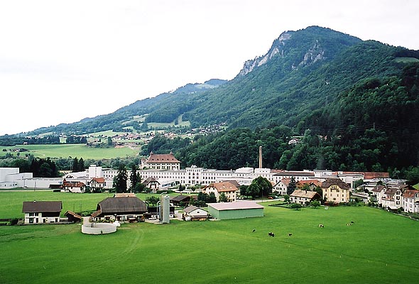

Broc
Hiking in Broc
Broc, located in the Fribourg region of Switzerland, is well-known for its beautiful landscapes and scenic hiking trails. The area is rich in natural beauty, featuring rolling hills, lush greenery, and stunning views of the surrounding mountains....
- Страна:
- Телефонный код: 026
- Код автомобильного номера: FR
- Координаты: 46° 36' 0" N, 7° 6' 0" E
- GPS треки (wikiloc): [Ссылка]
- Высота над уровнем моря: 718 м m
- Площадь: 10.06 кв.км
- Население: 2652
- Веб сайт: [Ссылка]


La Roche
Hiking in La Roche
La Roche, located in the region of Fribourg in Switzerland, is a fantastic destination for hikers looking to experience the beauty of the Swiss countryside. Here are some key points to consider when planning a hiking trip in La Roche:...
- Страна:
- Почтовый код: 1634
- Телефонный код: 026
- Код автомобильного номера: FR
- Координаты: 46° 42' 0" N, 7° 8' 0" E
- GPS треки (wikiloc): [Ссылка]
- Высота над уровнем моря: 747 м m
- Площадь: 24.03 кв.км
- Население: 1707
- Веб сайт: [Ссылка]


Corbières
Hiking in Corbières
Hiking in the Corbières region of Gruyère, Switzerland, offers a delightful blend of stunning landscapes, rich history, and diverse trails suitable for various skill levels. Here’s an overview of what you can expect:...
- Страна:
- Телефонный код: 026
- Код автомобильного номера: FR
- Координаты: 46° 40' 0" N, 7° 6' 0" E
- GPS треки (wikiloc): [Ссылка]
- Высота над уровнем моря: 714 м m
- Площадь: 9.60 кв.км
- Население: 877
- Веб сайт: [Ссылка]
Саль
Hiking in Саль
Sâles, located in the Fribourg region of Switzerland, is a beautiful destination for hiking enthusiasts. Nestled in the picturesque Swiss countryside, it's known for its stunning landscapes, rolling hills, and quaint villages. Here are some key highlights for hiking in and around Sâles:...
- Страна:
- Почтовый код: 1625
- Телефонный код: 026
- Код автомобильного номера: FR
- Координаты: 46° 38' 0" N, 6° 58' 0" E
- GPS треки (wikiloc): [Ссылка]
- Высота над уровнем моря: 825 м m
- Площадь: 18.78 кв.км
- Население: 1423
- Веб сайт: [Ссылка]


Riaz
Hiking in Riaz
Riaz, located in Saudi Arabia's Asir Province, offers a unique hiking experience characterized by its stunning landscapes, mountainous terrain, and rich biodiversity. Here are some key points for hiking in and around Riaz:...
- Страна:
- Почтовый код: 1632
- Телефонный код: 026
- Код автомобильного номера: FR
- Координаты: 46° 38' 0" N, 7° 4' 0" E
- GPS треки (wikiloc): [Ссылка]
- Высота над уровнем моря: 726 м m
- Площадь: 7.78 кв.км
- Население: 2627
- Веб сайт: [Ссылка]

Châtel-sur-Montsalvens
Hiking in Châtel-sur-Montsalvens
Châtel-sur-Montsalvens is a charming village in the Swiss canton of Fribourg, known for its stunning natural landscapes and access to various hiking trails. The area around Châtel-sur-Montsalvens offers a range of hiking opportunities that cater to different skill levels, from leisurely walks to more challenging hikes....
- Страна:
- Почтовый код: 1653
- Телефонный код: 026
- Код автомобильного номера: FR
- Координаты: 46° 37' 5" N, 7° 7' 40" E
- GPS треки (wikiloc): [Ссылка]
- Высота над уровнем моря: 1033 м m
- Площадь: 2.0 кв.км
- Население: 285
- Веб сайт: [Ссылка]

Бюль
Hiking in Бюль
Bulle, located in the canton of Fribourg in Switzerland, is surrounded by beautiful landscapes and offers various hiking opportunities. The region features scenic trails that cater to both casual hikers and more experienced adventurers. Here are some highlights of hiking in and around Bulle:...
- Страна:
- Телефонный код: 026
- Код автомобильного номера: FR
- Координаты: 46° 37' 0" N, 7° 3' 0" E
- GPS треки (wikiloc): [Ссылка]
- Высота над уровнем моря: 804 м m
- Площадь: 23.84 кв.км
- Население: 22709
- Веб сайт: [Ссылка]


Cerniat
Hiking in Cerniat
Cerniat is a picturesque village located in the Simmental valley of Switzerland. It's a fantastic destination for hiking enthusiasts, offering a range of trails that cater to different skill levels. Here are some highlights and tips for hiking in Cerniat:...
- Страна:
- Почтовый код: 1654
- Телефонный код: 026
- Код автомобильного номера: FR
- Координаты: 46° 38' 0" N, 7° 9' 0" E
- GPS треки (wikiloc): [Ссылка]
- Высота над уровнем моря: 927 м m
- Площадь: 33.78 кв.км
- Веб сайт: [Ссылка]
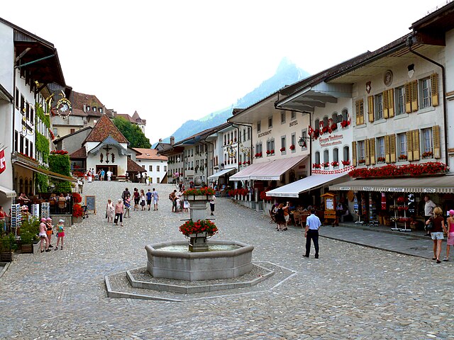
Грюйер
Hiking in Грюйер
Gruyères, located in the heart of the Swiss Alps, is renowned for its stunning landscapes and rich cultural heritage, making it a perfect destination for hiking enthusiasts. Here are some key features of hiking inGruyères:...
- Страна:
- Почтовый код: 1663
- Телефонный код: 026
- Код автомобильного номера: FR
- Координаты: 46° 35' 1" N, 7° 4' 55" E
- GPS треки (wikiloc): [Ссылка]
- Высота над уровнем моря: 810 м m
- Площадь: 28.39 кв.км
- Население: 2203
- Веб сайт: [Ссылка]


Le Pâquier
Hiking in Le Pâquier
Le Pâquier is a picturesque village located in the canton of Fribourg, Switzerland, and is surrounded by stunning landscapes that make it a lovely destination for hiking. Here are some insights about hiking in and around Le Pâquier:...
- Страна:
- Почтовый код: 1661
- Телефонный код: 026
- Код автомобильного номера: FR
- Координаты: 46° 35' 39" N, 7° 3' 19" E
- GPS треки (wikiloc): [Ссылка]
- Высота над уровнем моря: 747 м m
- Площадь: 4.5 кв.км
- Население: 1309
- Веб сайт: [Ссылка]