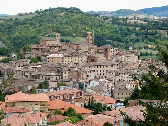
Гуальдо (Gualdo, Marche, Gualdo)
.svg)
- коммуна Италии
 Hiking in Гуальдо
Gualdo is a picturesque village located in the Marche region of Italy, surrounded by beautiful landscapes that are ideal for hiking enthusiasts. The area combines rich natural beauty with cultural heritage, making it a great destination for outdoor activities. Here are some highlights to consider when hiking in and around Gualdo:
Trails and Terrain
-
Variety of Trails: The region offers a range of hiking trails suitable for different skill levels, from easy walks to challenging hikes. Make sure to check local maps or guidebooks for detailed information on trail lengths and difficulty.
-
Scenic Views: Many trails in the area provide stunning views of the surrounding hills, valleys, and the Sibillini Mountains in the distance. Be sure to bring your camera to capture the beautiful landscapes.
-
Natural Parks: Gualdo is close to the Monti Sibillini National Park, which is known for its diverse flora and fauna. Ensure to explore some of the park's trails, where you can experience the beauty of high-altitude areas, deep valleys, and alpine meadows.
Flora and Fauna
-
Biodiversity: While hiking, you might encounter a wide variety of plant species as well as wildlife. Keep an eye out for birds, butterflies, and other native animals.
-
Flowering Seasons: Depending on the time of year, you may also enjoy spectacular wildflower displays, especially in spring and early summer.
Cultural Experiences
-
Historical Sites: Many trails take you past ancient ruins, churches, and other historical sites. Take some time to explore the local culture and history, investing in guided tours if available.
-
Local Cuisine: After a long day of hiking, enjoy a meal at one of Gualdo's restaurants or trattorias, where you can savor local delicacies from the Marche region.
Tips for Hiking in Gualdo
- Preparation: Make sure to carry plenty of water, snacks, and a first-aid kit. Wear sturdy hiking boots and dress in layers to accommodate changes in weather.
- Navigation: Carry a map or a GPS device, as some trails may not be well-marked. Consider downloading trail apps that provide information on routes in the area.
- Respect Nature: Follow local guidelines for when it comes to wildlife and vegetation, and stick to marked trails to minimize your impact on the environment.
Best Time to Visit
- The best months for hiking in Gualdo are typically from late spring to early fall (May to October), when the weather is mild and the scenery is vibrant.
Whether you are an experienced hiker or just looking for a leisurely walk, Gualdo and its surrounding areas provide a stunning backdrop for outdoor adventures.
- Страна:

- Почтовый код: 62020
- Телефонный код: 0733
- Код автомобильного номера: MC
- Координаты: 43° 4' 1" N, 13° 20' 17" E


- GPS треки (wikiloc): [Ссылка]
- Высота над уровнем моря: 650 м m
- Площадь: 22.22 кв.км
- Население: 786
- Веб сайт: http://www.comune.gualdo.mc.it/
- Википедия русская: wiki(ru)
- Википедия английская: wiki(en)
- Википедия национальная: wiki(it)
- Хранилище Wikidata: Wikidata: Q73884
- Катеория в википедии: [Ссылка]
- код Freebase: [/m/0gl6kz]
- код GeoNames: Альт: [6543021]
- ID отношения в OpenStreetMap: [42293]
- код ISTAT: 043021
- кадастровый код Италии: E228
Граничит с регионами:


Амандола
- коммуна Италии
Hiking in Амандола
Amandola is a charming town located in the Marche region of Italy, nestled within the Sibillini Mountains National Park. This area is a fantastic destination for hiking enthusiasts, offering a variety of trails that cater to different skill levels. Here are some key points about hiking in Amandola:...
- Страна:
- Почтовый код: 63857
- Телефонный код: 0736
- Код автомобильного номера: FM
- Координаты: 42° 58' 48" N, 13° 21' 27" E
- GPS треки (wikiloc): [Ссылка]
- Высота над уровнем моря: 550 м m
- Площадь: 69.5 кв.км
- Население: 3569
- Веб сайт: [Ссылка]


Пенна-Сан-Джованни
- коммуна Италии
Hiking in Пенна-Сан-Джованни
Penna San Giovanni, located in the Marche region of Italy, offers a charming experience for hikers and nature enthusiasts. This area is characterized by rolling hills, picturesque landscapes, and a rich cultural heritage. Here are some key points about hiking in Penna San Giovanni:...
- Страна:
- Почтовый код: 62020
- Телефонный код: 0733
- Код автомобильного номера: MC
- Координаты: 43° 3' 21" N, 13° 25' 24" E
- GPS треки (wikiloc): [Ссылка]
- Высота над уровнем моря: 630 м m
- Площадь: 28.08 кв.км
- Население: 1065
- Веб сайт: [Ссылка]


Сан-Джинезио
- коммуна Италии
Hiking in Сан-Джинезио
San Ginesio, located in the Marche region of Italy, is a picturesque medieval town situated on a hilltop. It offers a variety of hiking opportunities that allow you to explore its stunning landscapes, rich history, and natural beauty....
- Страна:
- Почтовый код: 62026
- Телефонный код: 0733
- Код автомобильного номера: MC
- Координаты: 43° 6' 27" N, 13° 19' 16" E
- GPS треки (wikiloc): [Ссылка]
- Высота над уровнем моря: 680 м m
- Площадь: 78.02 кв.км
- Население: 3376
- Веб сайт: [Ссылка]
Сант'Анджело-ин-Понтано
- коммуна Италии
Hiking in Сант'Анджело-ин-Понтано
Sant'Angelo in Pontano is a beautiful village located in the Marche region of Italy, known for its stunning landscapes, rich history, and excellent hiking opportunities. The surrounding area offers a variety of trails that cater to different skill levels, making it a suitable destination for both novice and experienced hikers....
- Страна:
- Почтовый код: 62020
- Телефонный код: 0733
- Код автомобильного номера: MC
- Координаты: 43° 5' 57" N, 13° 23' 43" E
- GPS треки (wikiloc): [Ссылка]
- Высота над уровнем моря: 473 м m
- Площадь: 27.38 кв.км
- Население: 1377
- Веб сайт: [Ссылка]

Сарнано
- коммуна Италии
Hiking in Сарнано
Sarnano, located in the Marche region of Italy, is a beautiful destination known for its stunning landscapes, rich history, and outdoor activities, including hiking. Nestled in the Sibillini Mountains, it offers a variety of trails suitable for different skill levels, from leisurely walks to challenging hikes....
- Страна:
- Почтовый код: 62028
- Телефонный код: 0733
- Код автомобильного номера: MC
- Координаты: 43° 2' 8" N, 13° 18' 3" E
- GPS треки (wikiloc): [Ссылка]
- Высота над уровнем моря: 539 м m
- Площадь: 63.17 кв.км
- Население: 3220
- Веб сайт: [Ссылка]