
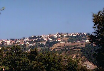
Гуардия-Ломбарди (Guardia Lombardi, Guardia Lombardi)

- коммуна Италии
 Hiking in Гуардия-Ломбарди
Guardia Lombardi is a charming village located in the Avellino province of Campania, Italy. Its mountainous terrain and beautiful landscapes make it a great destination for hiking enthusiasts. Here are some insights into hiking in the area:
Hiking Trails
-
Monte Terminio: This is one of the most popular hiking destinations near Guardia Lombardi. The mountain offers several trails with varying levels of difficulty, allowing hikers to experience panoramic views of the surrounding valleys and mountains.
-
Sentiero del Parco Regionale dei Monti Picentini: This trail runs through the Picentini Mountain Regional Park, which is home to diverse flora and fauna. The paths can take you through forests, along rivers, and to picturesque viewpoints.
-
Lago di Laceno: While a bit farther away, this lake area offers numerous hiking excursions, including paths around the lake and up to higher elevations, providing stunning scenery and a chance to explore the local wildlife.
Best Time to Hike
The ideal times to hike in Guardia Lombardi are typically in late spring (May to June) and early autumn (September to October) when the weather is mild and the trails are less crowded. Summer can be hot, while winter may bring snow to higher elevations, affecting trail accessibility.
Preparation
- Gear: Wear sturdy hiking boots and carry a backpack with essentials, including water, snacks, a first-aid kit, and a map or GPS device.
- Weather: Check the weather forecast before you go and be prepared for sudden changes in temperature or conditions, especially in mountainous areas.
- Regulations: Always adhere to local regulations regarding hiking, especially in protected areas like the Picentini Mountains.
Additional Attractions
After your hike, take some time to explore the village of Guardia Lombardi itself. The area is rich in history and culture, with beautiful churches and local cuisine that reflects the traditional flavors of Campania.
Whether you're an experienced hiker or just starting out, Guardia Lombardi offers a unique opportunity to experience the natural beauty of southern Italy!
- Страна:

- Почтовый код: 83040
- Телефонный код: 0827
- Код автомобильного номера: AV
- Координаты: 40° 57' 17" N, 15° 12' 35" E


- GPS треки (wikiloc): [Ссылка]
- Высота над уровнем моря: 998 м m
- Площадь: 55.77 кв.км
- Население: 1698
- Веб сайт: http://www.comune.guardialombardi.av.it/
- Википедия русская: wiki(ru)
- Википедия английская: wiki(en)
- Википедия национальная: wiki(it)
- Хранилище Wikidata: Wikidata: Q55042
- Катеория в википедии: [Ссылка]
- код Freebase: [/m/0fg09t]
- код GeoNames: Альт: [6537364]
- ID отношения в OpenStreetMap: [40947]
- код ISTAT: 064040
- кадастровый код Италии: E245
Включает регионы:
Borgo Le Taverne
Hiking in Borgo Le Taverne
Borgo le Taverne refers to a picturesque area, likely in Italy, that offers scenic hiking opportunities. While specific detailed trails and information about "Borgo le Taverne" may not be widely documented, if it is tied to a region known for outdoor activities, here's a general idea of what you can expect when hiking in such areas:...
- Страна:
- Почтовый код: 83040
- Телефонный код: 0827
- Координаты: 40° 57' 36" N, 15° 12' 25" E
- GPS треки (wikiloc): [Ссылка]
- Высота над уровнем моря: 910 м m
Граничит с регионами:
Андретта
- коммуна Италии
Hiking in Андретта
Andretta, located in the picturesque region of Himachal Pradesh, India, is a hidden gem for hiking enthusiasts. The area is surrounded by lush green mountains, serene landscapes, and vibrant local culture, making it an excellent destination for both seasoned hikers and beginners....
- Страна:
- Почтовый код: 83040
- Телефонный код: 0827
- Код автомобильного номера: AV
- Координаты: 40° 56' 18" N, 15° 19' 33" E
- GPS треки (wikiloc): [Ссылка]
- Высота над уровнем моря: 840 м m
- Площадь: 43.65 кв.км
- Население: 1853
- Веб сайт: [Ссылка]

Бизачча
- коммуна Италии
Hiking in Бизачча
Bisaccia is a charming town located in the province of Avellino, in the Campania region of southern Italy. This area is not only known for its historical architecture and rich culture but also offers some great hiking opportunities, particularly for those who enjoy rolling hills, scenic landscapes, and nature....
- Страна:
- Почтовый код: 83044
- Телефонный код: 0827
- Код автомобильного номера: AV
- Координаты: 41° 0' 47" N, 15° 22' 32" E
- GPS треки (wikiloc): [Ссылка]
- Высота над уровнем моря: 860 м m
- Площадь: 102.16 кв.км
- Население: 3815
- Веб сайт: [Ссылка]
Карифе
- коммуна Италии
Hiking in Карифе
Carife is a small town located in the Sicilian province of Catania, Italy. It is surrounded by beautiful landscapes and offers several opportunities for hiking and outdoor activities. Here are some aspects to consider when hiking in and around Carife:...
- Страна:
- Почтовый код: 83040
- Телефонный код: 0827
- Код автомобильного номера: AV
- Координаты: 41° 1' 38" N, 15° 12' 35" E
- GPS треки (wikiloc): [Ссылка]
- Высота над уровнем моря: 740 м m
- Площадь: 16.72 кв.км
- Население: 1381
- Веб сайт: [Ссылка]
Фридженто
- коммуна Италии
Hiking in Фридженто
Frigento, a town in the Avellino province of Italy, is surrounded by beautiful landscapes that offer various hiking opportunities. The area is characterized by rolling hills, lush greenery, and scenic views, making it a great destination for outdoor enthusiasts....
- Страна:
- Почтовый код: 83040
- Телефонный код: 0825
- Код автомобильного номера: AV
- Координаты: 41° 0' 44" N, 15° 6' 2" E
- GPS треки (wikiloc): [Ссылка]
- Высота над уровнем моря: 911 м m
- Площадь: 38.04 кв.км
- Население: 3663
- Веб сайт: [Ссылка]
Морра-Де-Санктис
- коммуна Италии
Hiking in Морра-Де-Санктис
Morra De Sanctis is a picturesque village located in the province of Avellino, Campania, Italy. It's known for its stunning natural landscapes and the surrounding region offers a variety of hiking opportunities for outdoor enthusiasts. Here's some information to help you plan a hiking trip in the area:...
- Страна:
- Почтовый код: 83040
- Телефонный код: 0827
- Код автомобильного номера: AV
- Координаты: 40° 55' 48" N, 15° 14' 37" E
- GPS треки (wikiloc): [Ссылка]
- Высота над уровнем моря: 863 м m
- Площадь: 30.41 кв.км
- Население: 1231
- Веб сайт: [Ссылка]

Рокка-Сан-Феличе
- коммуна Италии
Hiking in Рокка-Сан-Феличе
Rocca San Felice is a beautiful village in the province of Avellino, in the Campania region of southern Italy. Known for its stunning landscapes, rich history, and vibrant natural surroundings, it offers a range of hiking opportunities for outdoor enthusiasts....
- Страна:
- Почтовый код: 83050
- Телефонный код: 0827
- Код автомобильного номера: AV
- Координаты: 40° 57' 0" N, 15° 10' 0" E
- GPS треки (wikiloc): [Ссылка]
- Высота над уровнем моря: 740 м m
- Площадь: 14.41 кв.км
- Население: 835
- Веб сайт: [Ссылка]

Сант'Анджело-дей-Ломбарди
- коммуна Италии
Hiking in Сант'Анджело-дей-Ломбарди
Sant'Angelo dei Lombardi is located in the province of Avellino in the Campania region of Italy. It's a beautiful area known for its natural landscapes, nestled in the Apennine Mountains, making it a fantastic destination for hiking enthusiasts....
- Страна:
- Почтовый код: 83054
- Телефонный код: 0827
- Код автомобильного номера: AV
- Координаты: 40° 56' 0" N, 15° 11' 0" E
- GPS треки (wikiloc): [Ссылка]
- Высота над уровнем моря: 875 м m
- Площадь: 55.11 кв.км
- Население: 4207
- Веб сайт: [Ссылка]
Виллата
- коммуна Италии
Hiking in Виллата
Vallata, located in the Campania region of Italy, is a wonderful destination for hiking enthusiasts. Nestled within the foothills of the Apennine Mountains, it offers a variety of trails suitable for different skill levels, with breathtaking landscapes, diverse flora, and opportunities to explore local culture....
- Страна:
- Почтовый код: 83059
- Телефонный код: 0827
- Код автомобильного номера: AV
- Координаты: 41° 2' 25" N, 15° 15' 14" E
- GPS треки (wikiloc): [Ссылка]
- Высота над уровнем моря: 870 м m
- Площадь: 47.91 кв.км
- Население: 2659
- Веб сайт: [Ссылка]