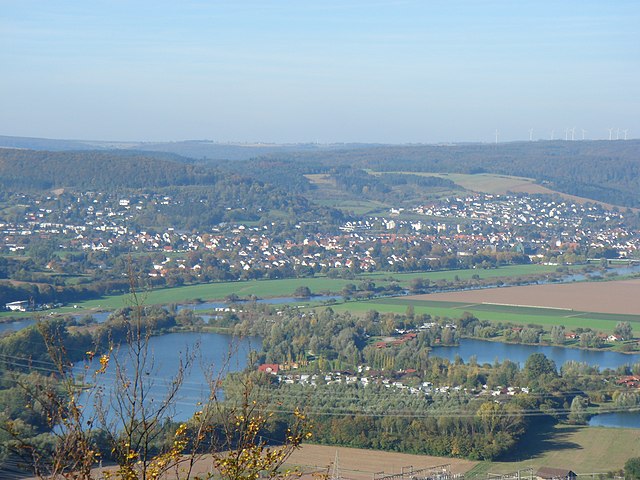
Хёкстер (Höxter, Höxter)

- город в земле Северный Рейн — Вестфалия, Германия
 Hiking in Хёкстер
Höxter is a charming town located in North Rhine-Westphalia, Germany, situated along the banks of the Weser River. It's surrounded by beautiful landscapes, making it an excellent destination for hiking enthusiasts. Here are some highlights about hiking in Höxter:
Scenic Trails
-
Weserbergland: The region around Höxter is part of the Weserbergland nature park, offering breathtaking views and diverse landscapes. Many hiking trails wind through forests, along the riverbanks, and up into the hills.
-
Eggegebirge Nature Park: Just a short distance from Höxter, this area features various hiking routes. The Egge Mountains are known for their rocky outcrops, lush green valleys, and rich flora and fauna.
-
The Hermannsweg: This well-known long-distance hiking route passes through beautiful sections of the region. It stretches for about 156 km from the Hermann monument in Detmold to the Porta Westfalica, offering panoramic views and a mix of terrain.
Local Attractions
-
Corvey Abbey: A UNESCO World Heritage site, this former Benedictine monastery is a great spot to visit before or after your hike. The grounds and surrounding area also offer nice walking paths.
-
Historical Town Center: Höxter's picturesque old town boasts half-timbered houses and quaint streets, perfect for a leisurely stroll post-hike.
Hiking Tips
-
Seasonal Considerations: The best time to hike in Höxter is typically during spring and fall when the weather is mild and the scenery is vibrant. Summer can be very warm, and winter may bring snow, impacting trail accessibility.
-
Trail Difficulty: Various trails cater to different skill levels, from easy walks suitable for families to more challenging hikes for experienced trekkers. Always check trail ratings and conditions before heading out.
-
Resources: Maps and information on local trails can often be found at tourist information centers or online hiking platforms. Consider using GPS devices or hiking apps for navigation.
Essentials to Bring
- Sturdy hiking shoes
- Weather-appropriate clothing
- Sufficient water and snacks
- Basic first-aid kit
- A map or a GPS device
Hiking in Höxter provides a wonderful way to experience the natural beauty and historical significance of the region. Whether you're looking for a leisurely walk or an adventurous trek, you'll find trails that will inspire and invigorate you!
- Страна:

- Почтовый код: 37671
- Телефонный код: 05531; 05278; 05277; 05275; 05271
- Код автомобильного номера: HX
- Координаты: 51° 46' 0" N, 9° 22' 0" E


- GPS треки (wikiloc): [Ссылка]
- Высота над уровнем моря: 96 м m
- Площадь: 158.16 кв.км
- Население: 29112
- Веб сайт: https://www.hoexter.de/
- Википедия русская: wiki(ru)
- Википедия английская: wiki(en)
- Википедия национальная: wiki(de)
- Хранилище Wikidata: Wikidata: Q16107
- Галерея изображений в википедии: [Ссылка]
- Катеория в википедии: [Ссылка]
- Карты в википедии: [Ссылка]
- код Freebase: [/m/04qh9j]
- код GeoNames: Альт: [2898321]
- код BNF: [120078966]
- код VIAF: Альт: [139573101]
- ID отношения в OpenStreetMap: [148593]
- код GND: Альт: [4025451-3]
- идентификатор местоположения ArchINFORM: [8698]
- код LCNAF: Альт: [n82036175]
- место в MusicBrainz: [8f0f5477-a8e0-45bd-8805-01be41aef939]
- WOEID: [662613]
- EMLO location ID: [17f586a4-93fc-4185-a370-b9f71e82b3d3]
- код места в Facebook: [110262875662156]
- Nomisma ID: [hoexter]
- идентификатор муниципалитетов в Германии: 05762020
Граничит с регионами:

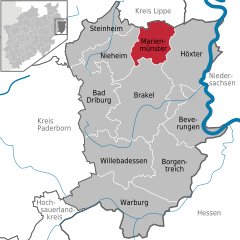
Мариенмюнстер
- город в земле Северный Рейн — Вестфалия, Германия
Hiking in Мариенмюнстер
Marienmünster, located in Germany, is an excellent destination for hiking enthusiasts. Nestled in the picturesque Landschaftsverband Westfalen-Lippe region, it offers a variety of trails that cater to hikers of different skill levels and interests....
- Страна:
- Почтовый код: 37696
- Телефонный код: 05276
- Код автомобильного номера: HX
- Координаты: 51° 49' 0" N, 9° 10' 59" E
- GPS треки (wikiloc): [Ссылка]
- Высота над уровнем моря: 257 м m
- Площадь: 64.35 кв.км
- Население: 5012
- Веб сайт: [Ссылка]

Беверунген
- город в земле Северный Рейн — Вестфалия, Германия
Hiking in Беверунген
Beverungen, located in North Rhine-Westphalia, Germany, offers a variety of hiking opportunities for outdoor enthusiasts. The region is characterized by its scenic landscapes, including rolling hills, wooded areas, and the nearby Weser River, making it a beautiful area to explore....
- Страна:
- Почтовый код: 37688
- Телефонный код: 05273
- Код автомобильного номера: HX
- Координаты: 51° 39' 46" N, 9° 22' 21" E
- GPS треки (wikiloc): [Ссылка]
- Высота над уровнем моря: 100 м m
- Площадь: 97.84 кв.км
- Население: 13176
- Веб сайт: [Ссылка]


Бракель
- город в земле Северный Рейн — Вестфалия, Германия
Hiking in Бракель
Brakel, located in North Rhine-Westphalia, Germany, is a charming town surrounded by beautiful landscapes, making it an excellent destination for hiking enthusiasts. The area offers a variety of trails that cater to different skill levels and interests....
- Страна:
- Почтовый код: 33034
- Телефонный код: 05645; 05276; 05648; 05272
- Код автомобильного номера: HX
- Координаты: 51° 43' 0" N, 9° 11' 0" E
- GPS треки (wikiloc): [Ссылка]
- Высота над уровнем моря: 135 м m
- Площадь: 173.74 кв.км
- Население: 16374
- Веб сайт: [Ссылка]

Хольцминден
Hiking in Хольцминден
Holzminden, located in Lower Saxony, Germany, offers a charming and scenic setting for hiking enthusiasts. The region is characterized by its lush landscapes, picturesque valleys, and the beautiful banks of the Weser River. Here are some highlights for hiking in Holzminden:...
- Страна:
- Почтовый код: 37603
- Телефонный код: 05531
- Код автомобильного номера: HOL
- Координаты: 51° 49' 41" N, 9° 26' 44" E
- GPS треки (wikiloc): [Ссылка]
- Высота над уровнем моря: 91 м m
- Площадь: 88.25 кв.км
- Население: 20132
- Веб сайт: [Ссылка]