Хаген-им-Бремишен (Hagen im Bremischen, Hagen im Bremischen)

 Hiking in Хаген-им-Бремишен
Hagen im Bremischen is a charming municipality located in Lower Saxony, Germany, situated near the northern edge of the Lüneburg Heath. While it may not be as well-known as other hiking destinations in Germany, it offers opportunities for outdoor activities, including hiking.
Hiking Trails and Areas
- Local Nature: The region around Hagen im Bremischen is characterized by a picturesque landscape featuring forests, fields, and rivers. This provides a backdrop for enjoyable hiking experiences.
- Nutzung von Wanderwegen: There are various hiking paths that cater to different skill levels. Local trails will typically take you through scenic countryside, allowing you to experience the natural beauty of the area.
Popular Routes
- Themed Trails: Check for any regional themed hiking trails that may focus on local history or ecology, which can enrich your hiking experience.
- Forest Trails: Trails running through nearby forests provide shade and an opportunity to enjoy the diverse flora and fauna.
Tips for Hiking in Hagen im Bremischen
- Trail Maps: Ensure you have reliable maps or a GPS device, as some trails may not be extensively marked.
- Weather Preparedness: The weather can change, so dress in layers and check forecasts before heading out.
- Local Guidance: Consider visiting local tourist information centers for details on the best trails and any guided hiking opportunities.
- Respect Nature: Follow Leave No Trace principles to preserve the natural beauty of the area.
Nearby Attractions
- Local Culture: Explore the small-town charm and perhaps enjoy local cuisine in Hagen im Bremischen after a day of hiking.
- Historic Sites: Look for historical landmarks in the area that you can combine with your hiking adventures.
In summary, while Hagen im Bremischen may not be a major hiking hub, its serene environment and access to natural landscapes make it a lovely destination for those looking to enjoy a peaceful hike.
- Страна:

- Почтовый код: 27628
- Телефонный код: 04746
- Код автомобильного номера: CUX
- Координаты: 53° 22' 0" N, 8° 39' 0" E


- GPS треки (wikiloc): [Ссылка]
- Высота над уровнем моря: 14 м m
- Площадь: 197.43 кв.км
- Население: 11110
- Веб сайт: http://www.hagen-cux.de/
- Википедия русская: wiki(ru)
- Википедия английская: wiki(en)
- Википедия национальная: wiki(de)
- Хранилище Wikidata: Wikidata: Q585546
- Катеория в википедии: [Ссылка]
- код Freebase: [/m/0c4qqm]
- код Freebase: [/m/0c4qqm]
- код Freebase: [/m/0c4qqm]
- код Freebase: [/m/0c4qqm]
- код Freebase: [/m/0c4qqm]
- код Freebase: [/m/0c4qqm]
- код GeoNames: Альт: [2912496]
- код GeoNames: Альт: [2912496]
- код GeoNames: Альт: [2912496]
- код GeoNames: Альт: [2912496]
- код GeoNames: Альт: [2912496]
- код GeoNames: Альт: [2912496]
- код BNF: [151849751]
- код BNF: [151849751]
- код BNF: [151849751]
- код BNF: [151849751]
- код BNF: [151849751]
- код BNF: [151849751]
- код VIAF: Альт: [170167804]
- код VIAF: Альт: [170167804]
- код VIAF: Альт: [170167804]
- код VIAF: Альт: [170167804]
- код VIAF: Альт: [170167804]
- код VIAF: Альт: [170167804]
- ID отношения в OpenStreetMap: [1161863]
- ID отношения в OpenStreetMap: [1161863]
- ID отношения в OpenStreetMap: [1161863]
- ID отношения в OpenStreetMap: [1161863]
- ID отношения в OpenStreetMap: [1161863]
- ID отношения в OpenStreetMap: [1161863]
- код GND: Альт: [4204921-0]
- код GND: Альт: [4204921-0]
- код GND: Альт: [4204921-0]
- код GND: Альт: [4204921-0]
- код GND: Альт: [4204921-0]
- код GND: Альт: [4204921-0]
- идентификатор муниципалитетов в Германии: 03352060
- идентификатор муниципалитетов в Германии: 03352060
- идентификатор муниципалитетов в Германии: 03352060
- идентификатор муниципалитетов в Германии: 03352060
- идентификатор муниципалитетов в Германии: 03352060
- идентификатор муниципалитетов в Германии: 03352060
Включает регионы:
Albstedt
Hiking in Albstedt
Albstedt, located near Hagen im Bremischen in Germany, offers a unique hiking experience with its picturesque landscapes and well-marked trails. The region is characterized by rolling hills, dense forests, and serene countryside, making it ideal for outdoor enthusiasts looking to explore nature....
- Страна:
- Почтовый код: 27628
- Телефонный код: 04746
- Координаты: 53° 19' 47" N, 8° 43' 5" E
- GPS треки (wikiloc): [Ссылка]
- Высота над уровнем моря: 21 м m
- Площадь: 9.5 кв.км
- Веб сайт: [Ссылка]
Heine
Hiking in Heine
Hiking in Heine, a locality in Hagen im Bremischen, offers a peaceful experience amid beautiful natural settings. The area is typically characterized by its rolling landscapes, lush greenery, and a network of well-marked trails that are suitable for various skill levels....
- Страна:
- Почтовый код: 27628
- Телефонный код: 04795
- Координаты: 53° 18' 11" N, 8° 39' 43" E
- GPS треки (wikiloc): [Ссылка]
- Высота над уровнем моря: 16 м m
- Площадь: 1.54 кв.км
Hoope
Hiking in Hoope
Hoope, located near Hagen im Bremischen in Lower Saxony, Germany, offers several opportunities for hiking enthusiasts. While it's a small area, the surrounding countryside features lush landscapes, forests, and rural trails that provide a peaceful hiking experience. Here are some aspects to consider when hiking in and around Hoope:...
- Страна:
- Почтовый код: 27628
- Телефонный код: 04795
- Координаты: 53° 18' 30" N, 8° 42' 4" E
- GPS треки (wikiloc): [Ссылка]
- Высота над уровнем моря: 20 м m
- Площадь: 4.41 кв.км
- Веб сайт: [Ссылка]
Lehnstedt
Hiking in Lehnstedt
Lehnstedt, located in the municipality of Hagen im Bremischen in Lower Saxony, Germany, offers opportunities for hiking enthusiasts looking to explore the natural beauty of the region. While the area may not be as famous as some larger national parks or hiking destinations, it has its unique charm that can be enjoyed through scenic trails and landscapes....
- Страна:
- Почтовый код: 27628
- Телефонный код: 04746
- Координаты: 53° 18' 40" N, 8° 38' 35" E
- GPS треки (wikiloc): [Ссылка]
- Высота над уровнем моря: 20 м m
- Площадь: 13.29 кв.км
- Веб сайт: [Ссылка]
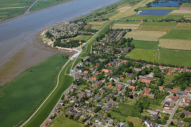
Hagen im Bremischen
Hiking in Hagen im Bremischen
Hagen im Bremischen is a small town located in Lower Saxony, Germany. The surrounding region offers a number of hiking opportunities, characterized by beautiful landscapes, woodlands, and rural areas....
- Страна:
- Координаты: 53° 21' 29" N, 8° 38' 46" E
- GPS треки (wikiloc): [Ссылка]

Wersabe
Hiking in Wersabe
Wersabe is a lesser-known but beautiful hiking destination that offers various trails suitable for different skill levels. While specific details about the area itself might be limited, I can provide some general tips and information on what you might expect and how to prepare for hiking in such regions....
- Страна:
- Почтовый код: 27628
- Телефонный код: 04702
- Координаты: 53° 19' 37" N, 8° 32' 3" E
- GPS треки (wikiloc): [Ссылка]
- Высота над уровнем моря: 1 м m
- Площадь: 9.05 кв.км
- Веб сайт: [Ссылка]

Offenwarden
Hiking in Offenwarden
Offenwarden, located in Hagen im Bremischen, is a charming area in Lower Saxony, Germany, that offers opportunities for outdoor activities, including hiking. While the region may not be as well-known as some larger national parks, it has its own unique appeal for those looking to enjoy nature....
- Страна:
- Почтовый код: 27628
- Телефонный код: 04702
- Координаты: 53° 20' 13" N, 8° 31' 59" E
- GPS треки (wikiloc): [Ссылка]
- Высота над уровнем моря: 3 м m
- Площадь: 8.49 кв.км
- Веб сайт: [Ссылка]

Wurthfleth
Hiking in Wurthfleth
Wurthfleth, located in Hagen im Bremischen in Lower Saxony, Germany, offers a variety of scenic landscapes perfect for hiking enthusiasts. The area is characterized by its natural beauty, including lush forests, quaint farmlands, and riverside paths along the Lesum River. Here are some tips and highlights for hiking in Wurthfleth and the surrounding region:...
- Страна:
- Почтовый код: 27628
- Телефонный код: 04296
- Координаты: 53° 17' 46" N, 8° 31' 43" E
- GPS треки (wikiloc): [Ссылка]
- Высота над уровнем моря: 0 м m
- Площадь: 9.79 кв.км
- Веб сайт: [Ссылка]

Dorfhagen
Hiking in Dorfhagen
Dorfhagen, located in Hagen im Bremischen, offers a pleasant environment for hiking enthusiasts who enjoy exploring rural landscapes and natural features. While the immediate area may not be as widely known as some larger hiking destinations, it has its charm and picturesque scenery suitable for outdoor activities....
- Страна:
- Почтовый код: 27628
- Телефонный код: 04746
- Координаты: 53° 20' 29" N, 8° 40' 59" E
- GPS треки (wikiloc): [Ссылка]
- Высота над уровнем моря: 14 м m
- Площадь: 7.05 кв.км
- Веб сайт: [Ссылка]
Kassebruch
Hiking in Kassebruch
Hiking in Kassebruch, located in Hagen im Bremischen, presents a delightful opportunity to explore the natural beauty of the Lower Saxony region of Germany. This area is characterized by lush greenery, diverse landscapes, and several trails that cater to different hiking skill levels....
- Страна:
- Почтовый код: 27628
- Телефонный код: 04746
- Координаты: 53° 22' 4" N, 8° 38' 10" E
- GPS треки (wikiloc): [Ссылка]
- Высота над уровнем моря: 12 м m
- Площадь: 8.61 кв.км
- Веб сайт: [Ссылка]

Вульсбюттель
Hiking in Вульсбюттель
Wulsbüttel is a small village located in Lower Saxony, Germany, and while it may not be a well-known hiking destination, it can offer some charming and peaceful trails in the surrounding area. Here are a few tips and insights if you're considering hiking in and around Wulsbüttel:...
- Страна:
- Почтовый код: 27628
- Телефонный код: 04746
- Код автомобильного номера: CUX
- Координаты: 53° 19' 0" N, 8° 40' 0" E
- GPS треки (wikiloc): [Ссылка]
- Высота над уровнем моря: 22 м m
- Площадь: 38.25 кв.км
- Веб сайт: [Ссылка]


Брамштедт
Hiking in Брамштедт
Bramstedt, a small town in the Lower Saxony region of Germany, offers a variety of opportunities for hiking enthusiasts. The surrounding landscapes are characterized by beautiful natural scenery, including forests, fields, and picturesque waterways....
- Страна:
- Почтовый код: 27628
- Код автомобильного номера: CUX
- Координаты: 53° 22' 0" N, 8° 41' 37" E
- GPS треки (wikiloc): [Ссылка]
- Высота над уровнем моря: 10 м m
- Площадь: 44.85 кв.км
- Население: 1857
- Веб сайт: [Ссылка]


Дрифтзете
Hiking in Дрифтзете
Driftsethe is a beautiful hiking destination known for its stunning landscapes and diverse trails. While I don’t have specific details about Driftsethe, I can provide you with the general attributes of a great hiking location that you might expect to find there....
- Страна:
- Почтовый код: 27628
- Телефонный код: 04746
- Код автомобильного номера: CUX
- Координаты: 53° 23' 0" N, 8° 37' 0" E
- GPS треки (wikiloc): [Ссылка]
- Высота над уровнем моря: 7 м m
- Площадь: 15.37 кв.км
- Веб сайт: [Ссылка]
Зандштедт
Hiking in Зандштедт
Sandstedt is a small village located in Lower Saxony, Germany, near the Weser River. While it's not widely known as a hiking destination, it offers some scenic views and opportunities for outdoor activities, primarily for those looking to explore the charming countryside and the riverside....
- Страна:
- Почтовый код: 27628
- Телефонный код: 04296
- Код автомобильного номера: CUX
- Координаты: 53° 22' 0" N, 8° 32' 0" E
- GPS треки (wikiloc): [Ссылка]
- Высота над уровнем моря: 2 м m
- Площадь: 56.22 кв.км

Утледе
Hiking in Утледе
Uthlede, a small village in Lower Saxony, Germany, isn't widely known for its hiking trails compared to some of the more famous locations in the country. However, the surrounding area offers serene landscapes and opportunities for enjoyable hikes. Here are some key points to consider if you're interested in hiking around Uthlede:...
- Страна:
- Почтовый код: 27628
- Телефонный код: 04296
- Код автомобильного номера: CUX
- Координаты: 53° 19' 0" N, 8° 35' 0" E
- GPS треки (wikiloc): [Ссылка]
- Высота над уровнем моря: 10 м m
- Площадь: 15.46 кв.км
- Веб сайт: [Ссылка]

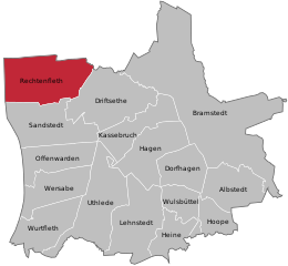
Rechtenfleth
Hiking in Rechtenfleth
Rechtenfleth is a small locality in Lower Saxony, Germany, located near the banks of the estuary of the River Weser. While it may not be a widely recognized hiking destination, the surrounding areas offer opportunities for outdoor activities, including hiking. Here are some aspects to consider while hiking in and around Rechtenfleth:...
- Страна:
- Почтовый код: 27628
- Телефонный код: 04702
- Координаты: 53° 22' 51" N, 8° 30' 32" E
- GPS треки (wikiloc): [Ссылка]
- Высота над уровнем моря: 0.5 м m
- Площадь: 15.47 кв.км
- Веб сайт: [Ссылка]