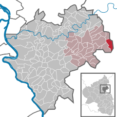
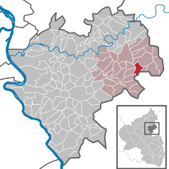
Объединённая община Ханштеттен (Verbandsgemeinde Hahnstätten, Verbandsgemeinde Hahnstätten)

 Hiking in Объединённая община Ханштеттен
Hahnstätten is a charming village located in the Verbandsgemeinde of Hahnstätten in the Rhineland-Palatinate region of Germany. This area is known for its scenic landscapes, including rolling hills, forests, and rivers, making it a great destination for hiking enthusiasts.
Hiking Trails:
-
Quality of Trails: The region offers a variety of well-marked hiking trails, ranging from easy walks suitable for families to more challenging routes for seasoned hikers. Many trails are maintained by local hiking clubs.
-
Kultur- und Naturpfad: One popular option is the Kultur- und Naturpfad, which combines cultural and natural elements, allowing hikers to experience local history while enjoying the beautiful surroundings.
-
Forest Paths: The nearby forests offer shaded paths that are ideal for warmer weather hikes. These trails are often less crowded, providing a peaceful hiking experience.
-
Scenic Views: Hikers can enjoy panoramic views from elevated trails, where you can often see the surrounding valleys and other villages. Sunrise or sunset hikes can provide particularly stunning vistas.
Local Attractions:
- Historical Sites: As you hike, you might come across historical landmarks, such as old mills or churches, which add cultural depth to your experience.
- Wildlife: The region is home to various wildlife, including deer, birds, and other native species, making it a great spot for nature lovers and photographers.
Tips for Hiking in Hahnstätten:
- Seasonal Considerations: Spring and autumn are particularly lovely times to hike due to the mild weather and beautiful foliage. Be aware of the weather, especially in winter when trails can be icy or muddy.
- Gear: Proper footwear is essential, as some trails can be rocky or uneven. Carry sufficient water, snacks, and a first-aid kit.
- Local Guides: Consider joining a guided hike to learn more about the local flora, fauna, and history. Local guides often provide valuable insights and enhance the hiking experience.
Accessibility:
- Hahnstätten is accessible by car and public transport, making it easy to reach various trailheads.
Community:
- Keep an eye out for local hiking events or meetups. The community often organizes group hikes, which can be a great way to meet fellow hiking enthusiasts.
In summary, Hahnstätten offers a variety of hiking opportunities in a picturesque setting, making it a perfect destination for both casual walkers and experienced hikers looking to explore the beauty of the Rhineland-Palatinate region.
- Страна:

- Столица: Ханштеттен
- Координаты: 50° 18' 0" N, 8° 4' 0" E


- GPS треки (wikiloc): [Ссылка]
- Веб сайт: http://www.vg-hahnstaetten.de/
- Википедия русская: wiki(ru)
- Википедия английская: wiki(en)
- Википедия национальная: wiki(de)
- Хранилище Wikidata: Wikidata: Q562538
- код Freebase: [/m/02z42gy]
- код GND: Альт: [4660971-4]
- код региона Германии: 071415004
Включает регионы:

Кальтенхольцхаузен
Hiking in Кальтенхольцхаузен
Kaltenholzhausen is a small village located in Germany, known for its scenic landscapes and proximity to nature. While it may not be as popular as some larger hiking destinations, it offers opportunities for outdoor enthusiasts to explore the beautiful countryside....
- Страна:
- Почтовый код: 65558
- Телефонный код: 06430
- Код автомобильного номера: EMS
- Координаты: 50° 18' 6" N, 8° 6' 26" E
- GPS треки (wikiloc): [Ссылка]
- Высота над уровнем моря: 235 м m
- Площадь: 6.06 кв.км
- Население: 576
- Веб сайт: [Ссылка]

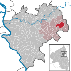
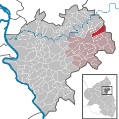
Ханштеттен
Hiking in Ханштеттен
Hahnstätten is a picturesque village located in the scenic Hesse region of Germany. It's surrounded by beautiful landscapes, making it an appealing destination for hiking enthusiasts. Here are some highlights of hiking in and around Hahnstätten:...
- Страна:
- Почтовый код: 65623
- Телефонный код: 06430
- Код автомобильного номера: EMS
- Координаты: 50° 18' 0" N, 8° 4' 0" E
- GPS треки (wikiloc): [Ссылка]
- Высота над уровнем моря: 145 м m
- Площадь: 10.70 кв.км
- Население: 2933
- Веб сайт: [Ссылка]


Флахт
Hiking in Флахт
Flacht is a small town in Germany, located in the state of Baden-Württemberg. While it may not be as widely recognized as some larger hiking destinations, there are still plenty of charming walking and hiking opportunities in and around the area....
- Страна:
- Почтовый код: 65558
- Телефонный код: 06432
- Код автомобильного номера: EMS
- Координаты: 50° 20' 43" N, 8° 3' 1" E
- GPS треки (wikiloc): [Ссылка]
- Высота над уровнем моря: 125 м m
- Площадь: 4.45 кв.км
- Население: 1047
- Веб сайт: [Ссылка]

Бургшвальбах
Hiking in Бургшвальбах
Burgschwalbach is a charming village located in the Rheinland-Palatinate region of Germany, surrounded by picturesque landscapes and nature trails, making it a great destination for hiking enthusiasts. Here are some details to keep in mind when planning a hike in and around Burgschwalbach:...
- Страна:
- Почтовый код: 65558
- Телефонный код: 06430
- Код автомобильного номера: EMS
- Координаты: 50° 17' 0" N, 8° 4' 49" E
- GPS треки (wikiloc): [Ссылка]
- Высота над уровнем моря: 170 м m
- Площадь: 9.21 кв.км
- Население: 1057
- Веб сайт: [Ссылка]
Нецбах
Hiking in Нецбах
Netzbach is a small village located in the Rhineland-Palatinate region of Germany, not far from larger towns like Bad Camberg and Limburg an der Lahn. The area around Netzbach offers beautiful natural landscapes, making it an appealing destination for hikers and nature enthusiasts....
- Страна:
- Почтовый код: 65623
- Телефонный код: 06430
- Код автомобильного номера: EMS
- Координаты: 50° 19' 4" N, 8° 5' 44" E
- GPS треки (wikiloc): [Ссылка]
- Высота над уровнем моря: 178 м m
- Площадь: 3.40 кв.км
- Население: 379
- Веб сайт: [Ссылка]
Лорхайм
Hiking in Лорхайм
Lohrheim is a small village located in Germany, surrounded by scenic landscapes that can offer a great hiking experience. While the village itself may not be as well-known as larger hiking areas, the surrounding regions provide opportunities for outdoor activities amidst nature....
- Страна:
- Почтовый код: 65558
- Телефонный код: 06430
- Код автомобильного номера: EMS
- Координаты: 50° 19' 9" N, 8° 2' 57" E
- GPS треки (wikiloc): [Ссылка]
- Высота над уровнем моря: 175 м m
- Площадь: 4.13 кв.км
- Население: 595
- Веб сайт: [Ссылка]

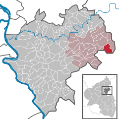
Обернайзен
Hiking in Обернайзен
Oberneisen is a charming village located in the Westerwald region of Germany, offering beautiful landscapes and a variety of hiking opportunities. The area is known for its rolling hills, dense forests, and scenic trails that cater to hikers of all skill levels. Here are some highlights for hiking in Oberneisen:...
- Страна:
- Почтовый код: 65558
- Телефонный код: 06430
- Код автомобильного номера: EMS
- Координаты: 50° 19' 32" N, 8° 4' 38" E
- GPS треки (wikiloc): [Ссылка]
- Высота над уровнем моря: 135 м m
- Площадь: 4.54 кв.км
- Население: 765
- Веб сайт: [Ссылка]
Шисхайм
Hiking in Шисхайм
Schiesheim appears to be a small village, and specific hiking information may not be widely documented. However, for hiking in regions like Schiesheim, it's common to find scenic trails that lead through beautiful landscapes, forests, and potentially near rivers or hills, depending on the geographical features of the area....
- Страна:
- Почтовый код: 65623
- Телефонный код: 06430
- Код автомобильного номера: EMS
- Координаты: 50° 16' 38" N, 8° 3' 21" E
- GPS треки (wikiloc): [Ссылка]
- Высота над уровнем моря: 160 м m
- Площадь: 1.43 кв.км
- Население: 252
- Веб сайт: [Ссылка]

Мудерсхаузен
Hiking in Мудерсхаузен
Mudershausen is a picturesque village located in Germany, known for its beautiful landscapes and hiking opportunities. While specific trails may vary, the surrounding area typically offers a mix of easy to moderate hikes suitable for various skill levels. Here are some general tips and highlights for hiking in and around Mudershausen:...
- Страна:
- Почтовый код: 65623
- Телефонный код: 06430
- Код автомобильного номера: EMS
- Координаты: 50° 16' 46" N, 8° 2' 25" E
- GPS треки (wikiloc): [Ссылка]
- Высота над уровнем моря: 265 м m
- Площадь: 4.72 кв.км
- Население: 424
- Веб сайт: [Ссылка]

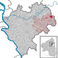
Нидернайзен
Hiking in Нидернайзен
Niederneisen is a charming village located in the Westerwald region of Germany, known for its beautiful landscapes and excellent hiking opportunities. The area is characterized by rolling hills, lush woodlands, and scenic views, making it a great destination for outdoor enthusiasts....
- Страна:
- Почтовый код: 65629
- Телефонный код: 06432
- Код автомобильного номера: EMS
- Координаты: 50° 20' 20" N, 8° 3' 21" E
- GPS треки (wikiloc): [Ссылка]
- Высота над уровнем моря: 130 м m
- Площадь: 7.95 кв.км
- Население: 1426
- Веб сайт: [Ссылка]