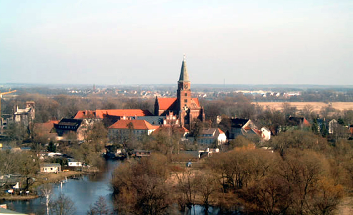
Хафельланд (Havelland District, Landkreis Havelland)

 Hiking in Хафельланд
Havelland, located in the Brandenburg region of Germany, offers a rich tapestry of hiking opportunities for nature enthusiasts and outdoor adventurers. Here’s what you can expect when hiking in this picturesque district:
Scenic Landscapes
Havelland is known for its diverse landscapes, which include serene lakes, dense forests, and rolling hills. The area is part of the larger Havelland nature park, providing a tranquil backdrop for hikes.
Hiking Trails
-
Havel River Trails: The banks of the Havel River provide numerous walking paths that allow hikers to enjoy the serene beauty of the waterway. You can connect with various sections of the river, which are ideal for both short and long hikes.
-
Brandenburg Forests: The forests in Havelland, such as the Ziegelei Forest, offer shaded trails and stunning biodiversity. These woods are perfect for leisurely walks and observing wildlife.
-
Historical Routes: Some trails in Havelland have historical significance, offering glimpses into the region’s past. You can find paths that lead to ancient castles and villages, enriching your hiking experience with cultural insights.
Nature and Wildlife
Havelland is home to a variety of flora and fauna. Birdwatchers will enjoy spotting numerous bird species, especially near the waterways. The rich ecosystems allow for interesting encounters, including deer, wild boars, and various plant life.
Accessibility
Many trails in Havelland are accessible for different fitness levels, making it suitable for families, casual hikers, and more experienced trekkers. Look for well-marked paths and signs to help guide your adventures.
Best Times to Hike
Spring and fall are ideal for hiking in Havelland, as the weather is typically mild and the natural scenery is especially stunning during these seasons. Summer can be enjoyable but may also be warmer, so plan for hydration and sun protection.
Local Amenities
You may find local guesthouses and inns that can provide refreshments and rest after a long day of hiking. Always check for the availability of facilities along your planned route.
Safety Tips
- Always stay on marked trails to protect the natural environment.
- Bring ample water and snacks, especially for longer hikes.
- Wear appropriate footwear to navigate varied terrains.
- Check the weather before your hike to ensure safe conditions.
Hiking in Havelland can be a rewarding experience, rich in natural beauty and tranquility. Prepare properly, and you will surely enjoy the charm of this beautiful district!
- Страна:

- Код автомобильного номера: HVL
- Координаты: 52° 38' 0" N, 12° 38' 0" E


- GPS треки (wikiloc): [Ссылка]
- Высота над уровнем моря: 32 м m
- Площадь: 1717.00 кв.км
- Население: 153294
- Веб сайт: http://www.havelland.de/
- Википедия русская: wiki(ru)
- Википедия английская: wiki(en)
- Википедия национальная: wiki(de)
- Хранилище Wikidata: Wikidata: Q6139
- Галерея изображений в википедии: [Ссылка]
- Катеория в википедии: [Ссылка]
- Карты в википедии: [Ссылка]
- код Freebase: [/m/0168zs]
- код GeoNames: Альт: [3249082]
- код VIAF: Альт: [143879822]
- ID отношения в OpenStreetMap: [62413]
- код GND: Альт: [4023870-2]
- идентификатор местоположения ArchINFORM: [4210]
- код TGN: [7076942]
- код NUTS: [DE408]
- код района Германии: 12063
Граничит с регионами:


Потсдам
- столица земли Бранденбург, Германия
Hiking in Потсдам
Potsdam, Germany, is known more for its historical landmarks and beautiful parks than for traditional hiking trails. However, there are plenty of opportunities for walking and enjoying the outdoors in and around the city. Here are some suggestions for hiking and walking experiences in Potsdam:...
- Страна:
- Почтовый код: 14480; 14478; 14476; 14473; 14471; 14469; 14482; 14467
- Телефонный код: 0331; 033201; 033208
- Код автомобильного номера: P
- Координаты: 52° 24' 0" N, 13° 4' 0" E
- GPS треки (wikiloc): [Ссылка]
- Высота над уровнем моря: 35 м m
- Площадь: 188.26 кв.км
- Население: 171810
- Веб сайт: [Ссылка]

Бранденбург-ан-дер-Хафель
- город в Германии
Hiking in Бранденбург-ан-дер-Хафель
Brandenburg an der Havel, located in the state of Brandenburg in Germany, offers a wonderful setting for hiking enthusiasts. The area is known for its beautiful landscapes, picturesque waterways, and rich history, making it a great destination for both casual walkers and serious hikers....
- Страна:
- Почтовый код: 14776; 14774; 14772; 14770
- Телефонный код: 03381
- Код автомобильного номера: BRB
- Координаты: 52° 24' 42" N, 12° 33' 22" E
- GPS треки (wikiloc): [Ссылка]
- Высота над уровнем моря: 32 м m
- Площадь: 228.8 кв.км
- Население: 71664
- Веб сайт: [Ссылка]
Штендаль
Hiking in Штендаль
Stendal is a district located in the state of Saxony-Anhalt in Germany. While it may not be as well-known for hiking as some other regions, it does provide some opportunities for outdoor activities in a scenic, largely rural setting. Here are some highlights about hiking in the Stendal district:...
- Страна:
- Код автомобильного номера: SDL; OBG; HV
- Координаты: 52° 41' 0" N, 11° 51' 0" E
- GPS треки (wikiloc): [Ссылка]
- Высота над уровнем моря: 39 м m
- Площадь: 2423.04 кв.км
- Население: 116666
- Веб сайт: [Ссылка]
Йерихов
Hiking in Йерихов
Jerichower Land is a picturesque area in the eastern part of Germany, situated in the state of Saxony-Anhalt. It’s known for its varied landscapes, historical sites, and a network of hiking trails that offer opportunities for both casual walkers and more seasoned hikers....
- Страна:
- Код автомобильного номера: JL; GNT; BRG
- Координаты: 52° 20' 0" N, 12° 4' 0" E
- GPS треки (wikiloc): [Ссылка]
- Высота над уровнем моря: 57 м m
- Веб сайт: [Ссылка]
Верхний Хафель
Hiking in Верхний Хафель
Oberhavel is a beautiful district located in the state of Brandenburg, Germany, known for its picturesque landscapes, lush forests, and numerous lakes. It's a fantastic destination for hiking enthusiasts. Here are some key points to consider when hiking in Oberhavel:...
- Страна:
- Код автомобильного номера: OHV
- Координаты: 52° 53' 0" N, 13° 15' 0" E
- GPS треки (wikiloc): [Ссылка]
- Высота над уровнем моря: 67 м m
- Площадь: 1795.77 кв.км
- Население: 202162
- Веб сайт: [Ссылка]
Восточный Пригниц-Руппин
Hiking in Восточный Пригниц-Руппин
Ostprignitz-Ruppin, located in the northeastern part of Brandenburg, Germany, offers a unique and picturesque hiking experience. The region is characterized by its diverse landscapes, which include sprawling forests, rolling hills, glacial lakes, and historical sites. Here are some highlights and tips for hiking in this area:...
- Страна:
- Код автомобильного номера: WK; OPR; NP; KY
- Координаты: 52° 58' 0" N, 12° 40' 0" E
- GPS треки (wikiloc): [Ссылка]
- Высота над уровнем моря: 53 м m
- Площадь: 2509.22 кв.км
- Население: 99125
- Веб сайт: [Ссылка]


Потсдам-Миттельмарк
Hiking in Потсдам-Миттельмарк
Potsdam-Mittelmark, located in the state of Brandenburg, Germany, offers a rich variety of hiking opportunities amidst picturesque landscapes and historical sites. Here are some key points to consider when hiking in this beautiful region:...
- Страна:
- Столица: Бад-Бельциг
- Почтовый код: 14806
- Код автомобильного номера: PM
- Координаты: 52° 13' 10" N, 12° 40' 30" E
- GPS треки (wikiloc): [Ссылка]
- Высота над уровнем моря: 40 м m
- Население: 204388
- Веб сайт: [Ссылка]


Берлин
- столица и одна из федеральных земель Германии
Hiking in Берлин
Hiking in and around Berlin offers a unique blend of urban exploration and access to nature. While Berlin itself is a bustling metropolis, there are various parks, forested areas, and nearby trails that provide excellent opportunities for hiking. Here are some highlights:...
- Страна:
- Почтовый код: 10115–14199
- Телефонный код: 030
- Код автомобильного номера: B; I
- Координаты: 52° 31' 0" N, 13° 23' 0" E
- GPS треки (wikiloc): [Ссылка]
- Высота над уровнем моря: 34 м m
- Площадь: 891.12 кв.км
- Население: 3611222
- Веб сайт: [Ссылка]