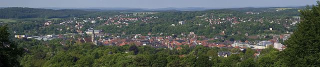
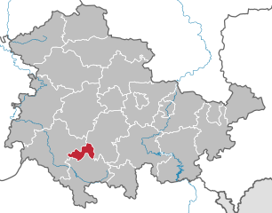
Хильдбургхаузен (Hildburghausen, Landkreis Hildburghausen)

- район земли Тюрингия, Германия
 Hiking in Хильдбургхаузен
Hildburghausen is a picturesque district located in the state of Thuringia, Germany, known for its diverse landscapes, history, and plenty of outdoor activities, including hiking. Here are some highlights for hiking in the Hildburghausen district:
Scenic Trails
-
Wanderweg Hildburghausen: This is a network of well-marked hiking trails that connect various villages and natural sights in the area. You can experience beautiful forests, rolling hills, and scenic viewpoints.
-
Thuringian Forest: To the south of Hildburghausen lies the Thuringian Forest, which boasts numerous hiking paths, including the famous Rennsteig long-distance trail. The Rennsteig offers breathtaking views and is ideal for hiking enthusiasts looking for both challenging and leisurely walks.
-
Hainich National Park: A bit further away, this UNESCO World Heritage site features deciduous forests and a rich biodiversity. Several trails meander through the park, offering opportunities to see unique flora and fauna.
Essential Tips
- Trail Markings: Most trails in this region are well-marked with signs. It helps to have a local map or a hiking app to navigate the routes.
- Weather Preparedness: The weather can change rapidly in the Thuringian region, so wear appropriate clothing and bring gear for varying conditions.
- Local Amenities: Many small towns and villages in the Hildburghausen district offer accommodation, food, and other amenities for hikers. Don’t hesitate to explore local cuisine!
Attractions
- Historical Sites: While hiking, you may pass historical landmarks, including castles and churches that offer a glimpse into the region's history.
- Nature Reserves: The area is home to several nature reserves and parks, where you can enjoy both hiking and wildlife watching.
Safety Considerations
- Always let someone know your hiking plan and estimated return time.
- Bring enough water, snacks, and a first-aid kit.
- Respect nature and stay on designated paths to preserve the local environment.
Whether you’re an experienced hiker or a beginner, Hildburghausen provides a lovely environment for a hiking adventure filled with natural beauty and cultural heritage.
- Страна:

- Код автомобильного номера: HBN
- Координаты: 50° 25' 12" N, 10° 45' 0" E


- GPS треки (wikiloc): [Ссылка]
- Высота над уровнем моря: 482 м m
- Площадь: 938.42 кв.км
- Население: 64524
- Веб сайт: http://www.landkreis-hildburghausen.de/
- Википедия русская: wiki(ru)
- Википедия английская: wiki(en)
- Википедия национальная: wiki(de)
- Хранилище Wikidata: Wikidata: Q7872
- Катеория в википедии: [Ссылка]
- код Freebase: [/m/01vl2l]
- код GeoNames: Альт: [2904803]
- код VIAF: Альт: [152513644]
- ID отношения в OpenStreetMap: [62365]
- код GND: Альт: [4095250-2]
- идентификатор местоположения ArchINFORM: [3639]
- код LCNAF: Альт: [n85207965]
- код TGN: [7172041]
- код NUTS: [DEG0E]
- код района Германии: 16069
Граничит с регионами:
Кобург
- район в Баварии, Германия
Hiking in Кобург
Coburg district, located in Bavaria, Germany, offers a variety of hiking opportunities for outdoor enthusiasts. The region is characterized by beautiful landscapes, including rolling hills, woodlands, and scenic views that make for enjoyable hiking experiences....
- Страна:
- Столица: Кобург
- Код автомобильного номера: NEC; CO
- Координаты: 50° 16' 0" N, 10° 55' 0" E
- GPS треки (wikiloc): [Ссылка]
- Высота над уровнем моря: 306 м m
- Площадь: 592.00 кв.км
- Население: 82033
- Веб сайт: [Ссылка]

Хасберге
- Район в Германии. Центр района — город Хасфурт.
Hiking in Хасберге
The Haßberge district, located in the northern part of Bavaria, Germany, is known for its beautiful landscapes, rolling hills, dense forests, and quaint villages, making it an excellent destination for hiking enthusiasts. Here are some key points about hiking in the Haßberge district:...
- Страна:
- Столица: Хасфурт
- Код автомобильного номера: HAS
- Координаты: 50° 4' 48" N, 10° 40' 12" E
- GPS треки (wikiloc): [Ссылка]
- Высота над уровнем моря: 368 м m
- Площадь: 956.00 кв.км
- Население: 80257
- Веб сайт: [Ссылка]

Рён-Грабфельд
Hiking in Рён-Грабфельд
Rhön-Grabfeld is a picturesque region located in Bavaria, Germany, renowned for its scenic landscapes, rolling hills, and rich natural beauty. It comprises part of the UNESCO Biosphere Reserve Rhön, which is characterized by its unique geology, biodiversity, and well-maintained hiking trails....
- Страна:
- Столица: Бад-Нойштадт-ан-дер-Зале
- Код автомобильного номера: MET; KÖN; NES
- Координаты: 50° 19' 48" N, 10° 15' 0" E
- GPS треки (wikiloc): [Ссылка]
- Высота над уровнем моря: 320 м m
- Площадь: 1022.00 кв.км
- Население: 77197
- Веб сайт: [Ссылка]

Зуль
- город в земле Тюрингия, Германия
Hiking in Зуль
Suhl, located in the Thuringia region of Germany, is surrounded by stunning natural landscapes, making it a wonderful destination for hiking enthusiasts. The area is characterized by diverse terrains, including forests, hills, and picturesque valleys, offering a range of trails suitable for all skill levels....
- Страна:
- Почтовый код: 98711; 98530; 98529; 98527
- Телефонный код: 036782; 036846; 03681
- Код автомобильного номера: SHL
- Координаты: 50° 36' 38" N, 10° 41' 35" E
- GPS треки (wikiloc): [Ссылка]
- Высота над уровнем моря: 422 м m
- Площадь: 103.02 кв.км
- Население: 36208
- Веб сайт: [Ссылка]