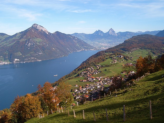
Изенталь (Isenthal, Isenthal)

- коммуна в Швейцарии
 Hiking in Изенталь
Isenthal is a beautiful valley located in the heart of Switzerland, specifically in the canton of Uri. It is known for its stunning landscapes, lush meadows, and impressive mountain views, making it a perfect destination for hiking enthusiasts. Here are some key highlights and tips for hiking in Isenthal:
Hiking Trails
-
Isenthal Valley Trail: This trail offers a gentle walk along the valley, allowing hikers to soak in the serene environment and enjoy views of the surrounding mountains.
-
Doppelzhorn: A more challenging hike, the trail to Doppelzhorn rewards hikers with breathtaking panoramic views of the Uri Mountains. It typically takes several hours to reach the summit.
-
Hiking to the Gitschenen: This trail takes you through the dense forests and meadows, eventually leading to the scenic Gitschenen area, where you can enjoy a comforting rest while absorbing nature’s tranquility.
-
Walenstöckli: A great option for those looking for moderate elevation gain, this hike features beautiful alpine flora and is perfect during late spring and summer.
Best Time to Visit
The best months for hiking in Isenthal are from late spring through early autumn (May to October). The weather is generally pleasant, and the trails are accessible.
Tips for Hiking in Isenthal
- Check Weather Conditions: Mountain weather can change quickly, so be sure to check forecasts before you head out.
- Stay Hydrated: Carry enough water, and consider bringing a portable water filter in case you want to refill from natural sources.
- Equipment: Good hiking boots, trekking poles, and appropriate clothing (layering is key) are essential for comfort and safety.
- Map and Navigation: Although many trails are well-marked, having a map and compass or a GPS app is a good idea.
- Respect Nature: Stay on marked trails to preserve the natural environment and wildlife.
- Wildlife Awareness: Be cautious of local wildlife and understand how to behave if you encounter animals.
Local Amenities
Isenthal offers several accommodations, from cozy guesthouses to hotels, and there are also options for dining. Try local Swiss cuisine for a delightful experience post-hike.
Conclusion
Whether you're a seasoned hiker or a beginner, Isenthal offers a range of trails that can suit any skill level. The combination of beautiful scenery, fresh mountain air, and tranquil surroundings makes it a fantastic hiking destination in Switzerland. Just remember to plan ahead, pack appropriately, and enjoy your adventure!
- Страна:

- Почтовый код: 6461
- Телефонный код: 041
- Код автомобильного номера: UR
- Координаты: 46° 53' 11" N, 8° 31' 28" E


- GPS треки (wikiloc): [Ссылка]
- Высота над уровнем моря: 1404 м m
- Площадь: 60.99 кв.км
- Население: 494
- Веб сайт: http://www.isenthal.ch
- Википедия русская: wiki(ru)
- Википедия английская: wiki(en)
- Википедия национальная: wiki(de)
- Хранилище Wikidata: Wikidata: Q65573
- Катеория в википедии: [Ссылка]
- код Freebase: [/m/0brlwn]
- код GeoNames: Альт: [7286149]
- код VIAF: Альт: [240532225]
- ID отношения в OpenStreetMap: [1683085]
- идентификатор HDS: [700]
- код швейцарского муниципалитета: [1211]
Граничит с регионами:


Энгельберг
Hiking in Энгельберг
Engelberg is a picturesque mountain village located in Switzerland, nestled in the heart of the Swiss Alps. It’s renowned for its stunning landscapes, fantastic hiking trails, and as a starting point for various outdoor activities. Here are some highlights of hiking in Engelberg:...
- Страна:
- Почтовый код: 6390
- Телефонный код: 041
- Код автомобильного номера: OW
- Координаты: 46° 49' 11" N, 8° 26' 3" E
- GPS треки (wikiloc): [Ссылка]
- Высота над уровнем моря: 1419 м m
- Площадь: 40.75 кв.км
- Население: 4155
- Веб сайт: [Ссылка]


Вольфеншиссен
Hiking in Вольфеншиссен
Wolfenschiessen is a charming village located in the Nidwalden region of Switzerland, nestled between the well-known mountains of the area. It's an excellent base for hiking enthusiasts due to its stunning natural scenery, well-marked trails, and access to the surrounding alpine landscapes....
- Страна:
- Почтовый код: 6386
- Телефонный код: 041
- Код автомобильного номера: NW
- Координаты: 46° 51' 46" N, 8° 23' 40" E
- GPS треки (wikiloc): [Ссылка]
- Высота над уровнем моря: 1516 м m
- Площадь: 92.76 кв.км
- Население: 2093
- Веб сайт: [Ссылка]


Зелисберг
- коммуна в Швейцарии
Hiking in Зелисберг
Seelisberg is a picturesque village located in the Uri region of Switzerland, known for its stunning views of Lake Lucerne and the surrounding mountains. It offers a variety of hiking trails suitable for different skill levels, making it an excellent destination for both novice and experienced hikers....
- Страна:
- Почтовый код: 6377
- Телефонный код: 041
- Код автомобильного номера: UR
- Координаты: 46° 57' 29" N, 8° 34' 21" E
- GPS треки (wikiloc): [Ссылка]
- Высота над уровнем моря: 736 м m
- Площадь: 13.34 кв.км
- Население: 679
- Веб сайт: [Ссылка]


Беккенрид
Hiking in Беккенрид
Beckenried, located in the canton of Nidwalden, Switzerland, is a beautiful destination for hiking enthusiasts. Nestled between Lake Lucerne and the surrounding mountains, it offers a variety of trails with stunning views, diverse landscapes, and the opportunity to explore the natural beauty of the region....
- Страна:
- Почтовый код: 6375
- Телефонный код: 041
- Код автомобильного номера: NW
- Координаты: 46° 57' 59" N, 8° 28' 29" E
- GPS треки (wikiloc): [Ссылка]
- Высота над уровнем моря: 448 м m
- Площадь: 32.95 кв.км
- Население: 3654
- Веб сайт: [Ссылка]

Эмметтен
Hiking in Эмметтен
Emmetten is a charming village located in Switzerland, offering stunning views of Lake Lucerne and the surrounding mountains, making it an excellent destination for hiking enthusiasts. Here are some key points to consider when planning a hike in Emmetten:...
- Страна:
- Почтовый код: 6376
- Телефонный код: 041
- Код автомобильного номера: NW
- Координаты: 46° 57' 24" N, 8° 31' 5" E
- GPS треки (wikiloc): [Ссылка]
- Высота над уровнем моря: 774 м m
- Площадь: 28.63 кв.км
- Население: 1401
- Веб сайт: [Ссылка]

Аттингхаузен
- коммуна в Швейцарии
Hiking in Аттингхаузен
Attinghausen is a charming village located in the Canton of Uri, Switzerland, surrounded by stunning alpine landscapes and offering a variety of hiking opportunities. Here are some highlights for hiking in and around Attinghausen:...
- Страна:
- Почтовый код: 6468
- Телефонный код: 041
- Код автомобильного номера: UR
- Координаты: 46° 49' 42" N, 8° 32' 37" E
- GPS треки (wikiloc): [Ссылка]
- Высота над уровнем моря: 2109 м m
- Площадь: 46.83 кв.км
- Население: 1711
- Веб сайт: [Ссылка]

Бауэн
- коммуна в Швейцарии, в кантоне Ури
Hiking in Бауэн
Bauen is a picturesque village located in the canton of Uri in Switzerland, nestled along the shores of Lake Uri and surrounded by stunning mountain landscapes. It offers a variety of hiking opportunities for outdoor enthusiasts of all skill levels. Here’s what you need to know about hiking in Bauen:...
- Страна:
- Почтовый код: 6466
- Телефонный код: 041
- Код автомобильного номера: UR
- Координаты: 46° 56' 10" N, 8° 34' 46" E
- GPS треки (wikiloc): [Ссылка]
- Высота над уровнем моря: 436 м m
- Площадь: 3.78 кв.км
- Население: 168
- Веб сайт: [Ссылка]


Флюелен
- коммуна в Швейцарии, в кантоне Ури
Hiking in Флюелен
Flüelen, located in the Canton of Uri in Switzerland, offers beautiful hiking opportunities that showcase the stunning landscapes of the Swiss Alps and the shores of Lake Uri. Here are some highlights and tips for hiking in the Flüelen area:...
- Страна:
- Почтовый код: 6454
- Телефонный код: 041
- Код автомобильного номера: UR
- Координаты: 46° 53' 59" N, 8° 37' 25" E
- GPS треки (wikiloc): [Ссылка]
- Высота над уровнем моря: 435 м m
- Площадь: 12.42 кв.км
- Население: 1975
- Веб сайт: [Ссылка]


Зеедорф
- коммуна в Швейцарии, в кантоне Ури
Hiking in Зеедорф
Seedorf is a charming village located in the Uri canton of Switzerland, nestled in the beautiful Reuss Valley. The region is known for its stunning landscapes, mountains, and lakes, making it an excellent destination for hiking enthusiasts....
- Страна:
- Почтовый код: 6462
- Телефонный код: 041
- Код автомобильного номера: UR
- Координаты: 46° 52' 58" N, 8° 36' 47" E
- GPS треки (wikiloc): [Ссылка]
- Высота над уровнем моря: 452 м m
- Площадь: 15.64 кв.км
- Население: 1804
- Веб сайт: [Ссылка]