
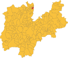
Кальдаро-сулла-Страда-дель-Вино (Kaltern an der Weinstraße, Caldaro sulla Strada del Vino)
.svg)
- коммуна Италии
 Hiking in Кальдаро-сулла-Страда-дель-Вино
Kaltern an der Weinstraße, located in South Tyrol, Italy, is a picturesque village nestled amid vineyards and rolling hills. It’s an excellent destination for hiking enthusiasts, offering a range of trails suitable for different skill levels, along with stunning views of the surrounding landscape, including Lake Kaltern and the impressive Dolomites.
Hiking Trails
-
Mitterberg Trail: This is a moderate hike that offers beautiful panoramic views of Lake Kaltern and the surrounding valleys. The trail winds through vineyards and forests, providing plenty of opportunities to take in the local flora and fauna.
-
Kaltern to Mendel Pass: This trail is a bit more challenging and takes you from Kaltern to the Mendel Pass. It features diverse terrain and rewarding vistas. The path is well-marked and offers various points to rest and enjoy a packed lunch.
-
Wine Trail: As Kaltern is known for its wine production, this trail takes you through vineyards and provides insight into the winemaking process. The hike is typically easy, making it suitable for families.
-
Lake Kaltern Circuit: This easy, scenic route circles Lake Kaltern, allowing hikers to enjoy the serene waters and charming lakeside views. It's perfect for a leisurely stroll or for those looking to enjoy a quiet day outdoors.
Best Time to Hike
The best time to hike in Kaltern is late spring (May-June) and early autumn (September-October), when the weather is mild and the landscapes are particularly beautiful. Summer can be warm, so starting hikes early in the day is advisable.
Preparation Tips
- Footwear: Wear sturdy hiking boots for better support and grip.
- Water and Snacks: Carry sufficient water and some snacks to keep your energy levels up.
- Weather Protection: Be prepared for varying weather conditions by bringing appropriate clothing, including layers and a rain jacket.
- Trail Maps: While trails are generally well-marked, having a map or hiking app can be helpful, especially for more remote paths.
Local Amenities
After a day of hiking, you can enjoy the local cuisine in one of the many restaurants or cafes in Kaltern. The area is famous for its wine, so don't miss the chance to taste some local varieties and enjoy South Tyrolean specialties.
Overall, Kaltern an der Weinstraße offers a delightful combination of natural beauty, cultural experiences, and excellent hiking opportunities. Whether you're a beginner or an experienced hiker, there are trails for everyone to enjoy!
- Страна:

- Почтовый код: 39052
- Телефонный код: 0471
- Код автомобильного номера: BZ
- Координаты: 46° 24' 48" N, 11° 14' 46" E


- GPS треки (wikiloc): [Ссылка]
- Высота над уровнем моря: 425 м m
- Площадь: 48.04 кв.км
- Население: 8046
- Веб сайт: http://www.gemeinde.kaltern.bz.it
- Википедия русская: wiki(ru)
- Википедия английская: wiki(en)
- Википедия национальная: wiki(it)
- Хранилище Wikidata: Wikidata: Q278942
- Галерея изображений в википедии: [Ссылка]
- Катеория в википедии: [Ссылка]
- код Freebase: [/m/05pdwh]
- код GeoNames: Альт: [6535969]
- код VIAF: Альт: [138453707]
- ID отношения в OpenStreetMap: [47121]
- код GND: Альт: [4029374-9]
- идентификатор местоположения ArchINFORM: [10128]
- код LCNAF: Альт: [n85380119]
- место в MusicBrainz: [e58f0d64-79d2-40d0-8fb8-35fb8cf99a2b]
- UN/LOCODE: [ITCA7]
- код NKC: [ge601751]
- код GAMEO: [Kaltern an der Weinstraße (Trentino-Alto Adige/Südtirol, Italy)]
- код ISTAT: 021015
- кадастровый код Италии: B397
Граничит с регионами:


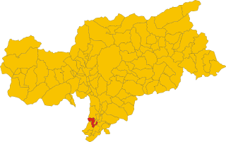
Аппьяно-сулла-Страда-дель-Вино
- коммуна Италии
Hiking in Аппьяно-сулла-Страда-дель-Вино
Eppan an der Weinstraße, located in the South Tyrol region of northern Italy, is a beautiful destination for hiking enthusiasts. Nestled amidst vineyards and rolling hills, this area offers a variety of trails suitable for all levels of hikers, from easy walks to more challenging treks. Here are some highlights of hiking in Eppan:...
- Страна:
- Почтовый код: 39050; 39057
- Телефонный код: 0471
- Код автомобильного номера: BZ
- Координаты: 46° 27' 0" N, 11° 16' 0" E
- GPS треки (wikiloc): [Ссылка]
- Высота над уровнем моря: 239 м m
- Площадь: 59.45 кв.км
- Население: 14941
- Веб сайт: [Ссылка]
Каварено
- коммуна Италии
Hiking in Каварено
Cavareno, a small town located in the Trentino region of northern Italy, is surrounded by the stunning natural landscapes of the Dolomites. This area is known for its beautiful hiking trails that cater to various skill levels, making it an excellent destination for outdoor enthusiasts....
- Страна:
- Почтовый код: 38011
- Телефонный код: 0463
- Код автомобильного номера: TN
- Координаты: 46° 25' 0" N, 11° 8' 0" E
- GPS треки (wikiloc): [Ссылка]
- Высота над уровнем моря: 973 м m
- Площадь: 9.48 кв.км
- Население: 1074
- Веб сайт: [Ссылка]

Руффре-Мендола
- коммуна Италии
Hiking in Руффре-Мендола
Ruffré-Mendola, located in the Trentino-Alto Adige region of northern Italy, is a fantastic area for hiking enthusiasts. The region is known for its stunning landscapes, including rolling hills, dense forests, and breathtaking mountain views. Here are some key points to consider if you're planning a hike in Ruffré-Mendola:...
- Страна:
- Почтовый код: 38010
- Телефонный код: 0463
- Код автомобильного номера: TN
- Координаты: 46° 25' 0" N, 11° 11' 0" E
- GPS треки (wikiloc): [Ссылка]
- Высота над уровнем моря: 1175 м m
- Площадь: 6.58 кв.км
- Население: 407
- Веб сайт: [Ссылка]


Сарнонико
- коммуна Италии
Hiking in Сарнонико
Sarnonico, located in the Trentino-Alto Adige region of northern Italy, offers stunning landscapes and a variety of hiking opportunities. It's a charming village nestled in the Non Valley, surrounded by the picturesque mountains of the Brenta Dolomites and the Maddalene Range....
- Страна:
- Почтовый код: 38010
- Телефонный код: 0463
- Код автомобильного номера: TN
- Координаты: 46° 25' 0" N, 11° 9' 0" E
- GPS треки (wikiloc): [Ссылка]
- Высота над уровнем моря: 980 м m
- Площадь: 12.19 кв.км
- Население: 778
- Веб сайт: [Ссылка]


Энья
- коммуна Италии
Hiking in Энья
Neumarkt (or Egna in Italian) is a charming town located in South Tyrol, Italy, nestled in the picturesque Adige Valley. This region is surrounded by stunning landscapes, mountains, and vineyards, making it an excellent destination for hiking enthusiasts. Here are some highlights and tips for hiking in the area:...
- Страна:
- Почтовый код: 39044
- Телефонный код: 0471
- Код автомобильного номера: BZ
- Координаты: 46° 19' 4" N, 11° 16' 24" E
- GPS треки (wikiloc): [Ссылка]
- Высота над уровнем моря: 214 м m
- Площадь: 23.57 кв.км
- Население: 5278
- Веб сайт: [Ссылка]

Термено-сулла-Страда-дель-Вино
- коммуна в Италии
Hiking in Термено-сулла-Страда-дель-Вино
Tramin an der Weinstraße, also known as Termeno sulla Strada del Vino, is a picturesque village in South Tyrol, northern Italy, famous for its wine production and stunning landscapes. The area is surrounded by vineyards, rolling hills, and mountains, making it an excellent destination for hiking enthusiasts....
- Страна:
- Почтовый код: 39040
- Телефонный код: 0471
- Код автомобильного номера: BZ
- Координаты: 46° 20' 29" N, 11° 14' 32" E
- GPS треки (wikiloc): [Ссылка]
- Высота над уровнем моря: 276 м m
- Площадь: 19.44 кв.км
- Население: 3383
- Веб сайт: [Ссылка]


Вадена
- коммуна в Италии
Hiking in Вадена
Vadena, located in the South Tyrol region of northern Italy, is a lesser-known but beautiful area that offers a variety of hiking opportunities. Here’s an overview of what to expect when hiking in this region:...
- Страна:
- Почтовый код: 39051
- Телефонный код: 0471
- Код автомобильного номера: BZ
- Координаты: 46° 25' 0" N, 11° 18' 0" E
- GPS треки (wikiloc): [Ссылка]
- Высота над уровнем моря: 243 м m
- Площадь: 15.22 кв.км
- Население: 1015
- Веб сайт: [Ссылка]