
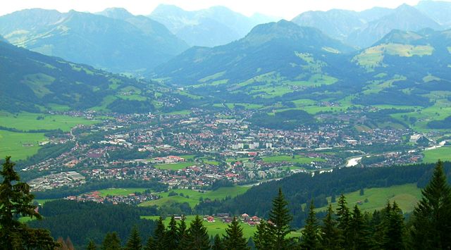
Кемптен (Kempten, Kempten)

- город в Баварии, Германия
 Hiking in Кемптен
Kempten, located in the Allgäu region of Bavaria, Germany, offers a variety of hiking options that cater to different skill levels and preferences. The picturesque surroundings, featuring the beautiful Allgäu Alps, lush meadows, and pristine rivers, make it an appealing destination for outdoor enthusiasts.
Popular Hiking Trails in Kempten:
-
Iller River Trail:
- A scenic route that follows the Iller River, offering flat paths that are suitable for families and casual hikers. The trail features beautiful views of the river and surrounding nature.
-
Hiking to the Durlangen:
- For more experienced hikers, this trail leads to Durlangen, providing more challenging terrain and rewarding views from higher elevations.
-
Allgäu Panorama Trail:
- A longer-distance trekking option that showcases the breathtaking landscapes of the Allgäu region. This trail connects various towns and offers stunning views of the Alps and rural scenery.
-
Nabelsberger Forge Trail:
- A cultural hike that combines nature with history. This trail features several historical sites, including the famous Nabelsberger Forge, all while walking through beautiful forests and fields.
-
Münster Cathedral Loop:
- A shorter, urban trail that enables hikers to explore Kempten’s historical center and visit the impressive Münster Cathedral, known for its stunning baroque architecture.
Things to Consider:
- Difficulty Levels: Trails range from easy to challenging, so you can select one that fits your fitness level and experience.
- Weather: Always check the local weather conditions before heading out, as alpine weather can change rapidly.
- Equipment: Good hiking shoes, appropriate clothing, and essentials like water, snacks, and a first-aid kit are recommended.
- Maps and Guides: It’s beneficial to have a detailed hiking map or a GPS device. Local visitor centers often provide hiking guides and information about trails.
- Wildlife and Nature: Keep an eye out for local wildlife and enjoy the diverse flora along the trails. Responsible hiking practices are advised, such as sticking to marked paths and disposing of trash properly.
Conclusion:
Whether you’re looking for a tranquil stroll along the river or a more challenging ascent into the mountains, Kempten offers diverse options for hiking enthusiasts. Enjoying a hike here not only allows for physical activity but also immerses you in the stunning beauty of the Bavarian countryside!
- Страна:

- Почтовый код: 87437; 87439; 87435
- Телефонный код: 0831
- Код автомобильного номера: KE
- Координаты: 47° 44' 0" N, 10° 19' 0" E


- GPS треки (wikiloc): [Ссылка]
- Высота над уровнем моря: 674 м m
- Площадь: 63.29 кв.км
- Население: 65624
- Веб сайт: http://www.kempten.de
- Википедия русская: wiki(ru)
- Википедия английская: wiki(en)
- Википедия национальная: wiki(de)
- Хранилище Wikidata: Wikidata: Q3994
- Галерея изображений в википедии: [Ссылка]
- Катеория в википедии: [Ссылка]
- Карты в википедии: [Ссылка]
- код Freebase: [/m/055wyt]
- код GeoNames: Альт: [3220884]
- код BNF: [122027486]
- код VIAF: Альт: [154784279]
- ID отношения в OpenStreetMap: [62701]
- код GND: Альт: [4030234-9]
- идентификатор местоположения ArchINFORM: [247]
- код LCNAF: Альт: [n81133727]
- место в MusicBrainz: [1f612a01-605c-498f-90b6-edfa7160e1de]
- код темы Quora: [Kempten]
- код SUDOC: [179250809]
- код в энциклопедии «Британника онлайн»: [place/Kempten]
- EMLO location ID: [536e69a9-981e-4b07-8c09-8b7e5fb56d69]
- Bavarikon ID: [ODB_A00000547]
- код ISNI: Альт: [0000 0004 0582 0665]
- код NLI: [000988840]
- код NUTS: [DE273]
- Nomisma ID: [kempten]
- идентификатор муниципалитетов в Германии: 09763000
- код района Германии: 09763
Включает регионы:
Felben
Hiking in Felben
Felben, located near Kempten in the Allgäu region of Germany, offers beautiful hiking opportunities with scenic landscapes, lush forests, and charming villages. The area is rich in natural beauty and cultural heritage, making it great for hiking enthusiasts of all levels....
- Страна:
- Почтовый код: 87437
- Телефонный код: 0831
- Координаты: 47° 45' 19" N, 10° 20' 0" E
- GPS треки (wikiloc): [Ссылка]
- Высота над уровнем моря: 700 м m
Dolders
Hiking in Dolders
It seems there might be a slight typo or misunderstanding in your request, as there isn't a well-known hiking destination specifically called "Dolders." However, if you're referring to a particular area, region, or trail, please clarify, and I'll be happy to provide you with the relevant information....
- Страна:
- Почтовый код: 87437
- Телефонный код: 0831
- Координаты: 47° 44' 39" N, 10° 20' 26" E
- GPS треки (wikiloc): [Ссылка]
- Высота над уровнем моря: 730 м m

Хиршдорф
- район Кемптена, Бавария
Hiking in Хиршдорф
Hirschdorf is a lesser-known location that may not have extensive hiking resources, but if you're in the area, it's likely to offer beautiful landscapes and potential trails to explore. Generally, when hiking in any rural or mountainous area, here are a few tips to keep in mind:...
- Страна:
- Почтовый код: 87439
- Телефонный код: 0831
- Координаты: 47° 45' 54" N, 10° 17' 55" E
- GPS треки (wikiloc): [Ссылка]
- Высота над уровнем моря: 662 м m


Lenzfried
Hiking in Lenzfried
Lenzfried is a beautiful area located near the town of Füssen in Bavaria, Germany, and is well-known for its picturesque landscapes and access to various hiking trails. It's a fantastic destination for both novice and experienced hikers. Here are some highlights about hiking in Lenzfried:...
- Страна:
- Почтовый код: 87437
- Телефонный код: 0831
- Координаты: 47° 43' 45" N, 10° 20' 13" E
- GPS треки (wikiloc): [Ссылка]
- Высота над уровнем моря: 728 м m

Хайлигкройц
- район Кемптена, Бавария
Hiking in Хайлигкройц
Heiligkreuz, located in Kempten, Bavaria, Germany, is a beautiful area for hiking, offering a mix of scenic views, rich history, and a variety of trails suited for different skill levels. Here are some highlights and information about hiking in this region:...
- Страна:
- Почтовый код: 87439
- Телефонный код: 0831
- Координаты: 47° 44' 56" N, 10° 16' 52" E
- GPS треки (wikiloc): [Ссылка]
- Высота над уровнем моря: 710 м m
Greinats
Hiking in Greinats
Greinats, often referred to in outdoor contexts, may not be a widely recognized location but could pertain to an area known for hiking or outdoor activities locally. If you're looking to find hiking opportunities in a place by that name or similar, it’s best to consider the following aspects for a successful hike:...
- Страна:
- Почтовый код: 87437
- Телефонный код: 0831
- Координаты: 47° 44' 45" N, 10° 21' 31" E
- GPS треки (wikiloc): [Ссылка]
- Высота над уровнем моря: 730 м m
Rappenscheuchen
Hiking in Rappenscheuchen
It seems like there might be a misunderstanding or a typo regarding "Rappenscheuchen." As of my last update, there is no widely recognized hiking destination by that name. If you're referring to a specific place, it might be less known or go by a different name....
- Страна:
- Почтовый код: 87439
- Телефонный код: 0831
- Координаты: 47° 46' 8" N, 10° 17' 9" E
- GPS треки (wikiloc): [Ссылка]
- Высота над уровнем моря: 670 м m

Reinharts
Hiking in Reinharts
Reinharts is not widely known as a prominent hiking destination, so there might be some confusion regarding its whereabouts or significance. If you're referring to a specific area or trail system called "Reinharts," it could be a local or less prominent location that doesn't have extensive information available....
- Страна:
- Почтовый код: 87437
- Телефонный код: 0831
- Координаты: 47° 44' 28" N, 10° 20' 18" E
- GPS треки (wikiloc): [Ссылка]
- Высота над уровнем моря: 730 м m
Thingers
Hiking in Thingers
It seems like "Thingers" might be a misspelling or a less-known hiking location as it doesn’t match any widely recognized hiking destination. However, if you meant a different location, such as the "Finger Lakes" in New York or any other area with a similar name, please clarify, and I can provide detailed information about hiking in that region....
- Страна:
- Почтовый код: 87439
- Телефонный код: 0831
- Координаты: 47° 44' 9" N, 10° 17' 40" E
- GPS треки (wikiloc): [Ссылка]
- Высота над уровнем моря: 678 м m
Ursulasried
Hiking in Ursulasried
Ursulasried is a charming village located in Bavaria, Germany, near the Alps. The region offers beautiful landscapes and a variety of hiking opportunities suitable for different skill levels. Here's an overview of what you can expect when hiking in the Ursulasried area:...
- Страна:
- Почтовый код: 87437
- Телефонный код: 0831
- Координаты: 47° 45' 7" N, 10° 19' 8" E
- GPS треки (wikiloc): [Ссылка]
- Высота над уровнем моря: 660 м m
Hochstraß
Hiking in Hochstraß
Hochstraß, located near Kempten in the Allgäu region of Bavaria, Germany, offers a beautiful setting for hiking enthusiasts. The area is characterized by its scenic landscapes, lush forests, and panoramic views of the surrounding mountains. Here are some highlights and tips for hiking in Hochstraß:...
- Страна:
- Почтовый код: 87437
- Телефонный код: 0831
- Координаты: 47° 44' 45" N, 10° 21' 31" E
- GPS треки (wikiloc): [Ссылка]
- Высота над уровнем моря: 750 м m
Leubas
Hiking in Leubas
Leubas, a district of Kempten in Bavaria, Germany, is an excellent location for hiking enthusiasts. The area is characterized by beautiful landscapes, rolling hills, and scenic views of the Allgäu region. Here are some insights and tips for hiking in Leubas:...
- Страна:
- Почтовый код: 87437
- Телефонный код: 0831
- Координаты: 47° 45' 56" N, 10° 20' 14" E
- GPS треки (wikiloc): [Ссылка]
- Высота над уровнем моря: 682 м m
Neuhausen
Hiking in Neuhausen
Neuhausen, located near Kempten in Bavaria, Germany, offers a wealth of hiking opportunities for both beginners and experienced hikers alike. The region is characterized by its scenic landscapes, including rolling hills, lush forests, and panoramic views of the Allgäu Alps....
- Страна:
- Почтовый код: 87439
- Телефонный код: 0831
- Координаты: 47° 45' 5" N, 10° 17' 27" E
- GPS треки (wikiloc): [Ссылка]
- Высота над уровнем моря: 689 м m
Riederau
Hiking in Riederau
Riederau, located near Kempten in Bavaria, Germany, is a beautiful area for hiking, offering a variety of trails that cater to different skill levels. The region is characterized by picturesque landscapes, including lush forests, rolling hills, and stunning views of the Allgäu Alps....
- Страна:
- Почтовый код: 87437
- Телефонный код: 0831
- Координаты: 47° 45' 19" N, 10° 18' 31" E
- GPS треки (wikiloc): [Ссылка]
- Высота над уровнем моря: 660 м m


Sommers
Hiking in Sommers
Sommers, located near Kempten in Bavaria, Germany, offers a range of hiking opportunities that showcase the beautiful landscapes of the Allgäu region. Here are some key points to consider for hiking in that area:...
- Страна:
- Координаты: 47° 45' 23" N, 10° 21' 50" E
- GPS треки (wikiloc): [Ссылка]
- Высота над уровнем моря: 740 м m

Stadtweiher (Kempten)
Hiking in Stadtweiher (Kempten)
Stadtweiher in Kempten, Germany, is a beautiful area for outdoor activities, including hiking. The Stadtweiher itself is an appealing lake surrounded by lush greenery, making it a great spot for nature walks and leisurely hikes. Here’s what you can expect when hiking in this area:...
- Страна:
- Координаты: 47° 42' 44" N, 10° 17' 14" E
- GPS треки (wikiloc): [Ссылка]
- Высота над уровнем моря: 722 м m
- Площадь: 0.05 кв.км

Letten
Hiking in Letten
Hiking in Letten, located in Kempten, Germany, offers a combination of beautiful landscapes, cultural heritage, and accessibility for both novice and experienced hikers. The area is nestled in the Allgäu region, known for its picturesque rolling hills, forests, and proximity to the Alps....
- Страна:
- Почтовый код: 87437
- Телефонный код: 0831
- Координаты: 47° 42' 57" N, 10° 20' 43" E
- GPS треки (wikiloc): [Ссылка]
- Высота над уровнем моря: 740 м m
Tannen
Hiking in Tannen
Tannen, located near Kempten in Bavaria, Germany, offers beautiful hiking opportunities set in the picturesque Allgäu region. The area is known for its stunning natural landscapes, rolling hills, lush forests, and scenic views of the surrounding mountains....
- Страна:
- Почтовый код: 87437
- Телефонный код: 0831
- Координаты: 47° 43' 21" N, 10° 21' 22" E
- GPS треки (wikiloc): [Ссылка]
- Высота над уровнем моря: 730 м m
Wettmannsberg
Hiking in Wettmannsberg
Wettmannsberg is a picturesque area located in Bavaria, Germany, known for its scenic landscapes, serene forests, and beautiful hills, making it an excellent destination for hiking enthusiasts. Here are some key points to consider when hiking in Wettmannsberg:...
- Страна:
- Почтовый код: 87437
- Телефонный код: 0831
- Координаты: 47° 44' 4" N, 10° 20' 27" E
- GPS треки (wikiloc): [Ссылка]
- Высота над уровнем моря: 740 м m
Kargen
Hiking in Kargen
Kargen, located in the vicinity of Kempten in Bavaria, Germany, offers a scenic backdrop for hikers who wish to explore its beautiful landscapes. The area is rich in natural beauty, featuring lush forests, rolling hills, and picturesque valleys....
- Страна:
- Почтовый код: 87437
- Телефонный код: 0831
- Координаты: 47° 45' 38" N, 10° 21' 56" E
- GPS треки (wikiloc): [Ссылка]
- Высота над уровнем моря: 735 м m
Leupratsried
Hiking in Leupratsried
Leupratsried, located in the scenic region of Bavaria, Germany, may not be as widely known as some other hiking destinations, but it offers beautiful landscapes and a variety of trails suitable for different skill levels. While specific trail details can vary, here are some general tips and highlights one might expect when hiking in this area:...
- Страна:
- Почтовый код: 87437
- Телефонный код: 0831
- Координаты: 47° 45' 46" N, 10° 20' 32" E
- GPS треки (wikiloc): [Ссылка]
- Высота над уровнем моря: 713 м m
Rößlings
Hiking in Rößlings
Rößlings is not a location I have specific information on, as it does not seem to be widely recognized or may not have a large online presence. It’s possible that you might be referring to a lesser-known trail or a regional hiking area in Germany....
- Страна:
- Почтовый код: 87437
- Телефонный код: 0831
- Координаты: 47° 43' 0" N, 10° 21' 16" E
- GPS треки (wikiloc): [Ссылка]
- Высота над уровнем моря: 732 м m
Grub
Hiking in Grub
Grub, a district of Kempten in Bavaria, Germany, offers access to beautiful hiking opportunities in the surrounding Allgäu region, known for its picturesque landscapes, rolling hills, and scenic views. Here are some highlights about hiking in and around Grub:...
- Страна:
- Почтовый код: 87437
- Телефонный код: 0831
- Координаты: 47° 45' 30" N, 10° 21' 31" E
- GPS треки (wikiloc): [Ссылка]
- Высота над уровнем моря: 740 м m

Hafenthal
Hiking in Hafenthal
Hafenthal, located near Kempten in Bavaria, Germany, is a beautiful area for hiking, offering various trails for both novice and experienced hikers. The region is known for its lush landscapes, scenic views, and well-marked trails that wind through forests, meadows, and along rivers....
- Страна:
- Почтовый код: 87437
- Телефонный код: 0831
- Координаты: 47° 46' 3" N, 10° 19' 1" E
- GPS треки (wikiloc): [Ссылка]
- Высота над уровнем моря: 680 м m
Haßberg
Hiking in Haßberg
Hiking in the Haßberg region near Kempten, located in Bavaria, Germany, offers a beautiful blend of lush landscapes, historical sites, and well-maintained trails. Here are some highlights and tips for hiking in this area:...
- Страна:
- Почтовый код: 87437
- Телефонный код: 0831
- Координаты: 47° 42' 56" N, 10° 22' 6" E
- GPS треки (wikiloc): [Ссылка]
- Высота над уровнем моря: 770 м m
Hinterholz
Hiking in Hinterholz
Hinterholz, located near Kempten in Bavaria, Germany, is a great spot for hiking amid beautiful natural surroundings. The region is characterized by its rolling hills, lush forests, and stunning views of the Alps, making it ideal for hikers of all skill levels....
- Страна:
- Почтовый код: 87437
- Телефонный код: 0831
- Координаты: 47° 43' 27" N, 10° 20' 46" E
- GPS треки (wikiloc): [Ссылка]
- Высота над уровнем моря: 740 м m
Hub
Hiking in Hub
Hiking around Kempten, a picturesque town located in Bavaria, Germany, offers a variety of trails and beautiful scenery, ranging from gentle walks to more challenging hikes. Here are some aspects to consider for a great hiking experience in the area:...
- Страна:
- Почтовый код: 87437
- Телефонный код: 0831
- Координаты: 47° 45' 45" N, 10° 19' 31" E
- GPS треки (wikiloc): [Ссылка]
- Высота над уровнем моря: 691 м m
Klingen
Hiking in Klingen
Klingen, located near Kempten in Bavaria, Germany, offers a variety of hiking opportunities that showcase the natural beauty of the Allgäu region. The area features scenic trails that cater to different skill levels, making it suitable for both casual walkers and more experienced hikers....
- Страна:
- Почтовый код: 87437
- Телефонный код: 0831
- Координаты: 47° 43' 12" N, 10° 21' 30" E
- GPS треки (wikiloc): [Ссылка]
- Высота над уровнем моря: 725 м m
Moos
Hiking in Moos
Moos, located near Kempten in Bavaria, Germany, is an excellent area for hiking enthusiasts, offering beautiful landscapes and a variety of trails. The region is characterized by its rolling hills, lush forests, and scenic views of the Allgäu Alps....
- Страна:
- Почтовый код: 87437
- Телефонный код: 0831
- Координаты: 47° 43' 21" N, 10° 21' 24" E
- GPS треки (wikiloc): [Ссылка]
- Высота над уровнем моря: 730 м m
Мотцен
- район Кемптена, Бавария
Hiking in Мотцен
Motzen, located in the Kempten area of Bavaria, Germany, offers a variety of hiking opportunities amid beautiful landscapes. The region is known for its picturesque surroundings, which include rolling hills, forests, and scenic views of the Allgäu Alps....
- Страна:
- Почтовый код: 87437
- Телефонный код: 0831
- Координаты: 47° 45' 36" N, 10° 20' 53" E
- GPS треки (wikiloc): [Ссылка]
- Высота над уровнем моря: 735 м m
Oberbühl
Hiking in Oberbühl
Oberbühl, located near Kempten in Bavaria, Germany, offers beautiful hiking opportunities in a picturesque natural setting. The region is characterized by rolling hills, dense forests, and stunning views of the Allgäu Alps, making it an appealing destination for both casual walkers and experienced hikers....
- Страна:
- Почтовый код: 87437
- Телефонный код: 0831
- Координаты: 47° 43' 12" N, 10° 21' 24" E
- GPS треки (wikiloc): [Ссылка]
- Высота над уровнем моря: 720 м m
Rockhöflings
Hiking in Rockhöflings
It seems like there might be a typographical error in your request, as "Rockhöflings" doesn't correspond to any well-known hiking areas or trails. However, if you intended to refer to a specific location or region, please provide a bit more detail....
- Страна:
- Почтовый код: 87437
- Телефонный код: 0831
- Координаты: 47° 43' 14" N, 10° 21' 51" E
- GPS треки (wikiloc): [Ссылка]
- Высота над уровнем моря: 740 м m


Sankt Mang
Hiking in Sankt Mang
Sankt Mang, a district in Kempten, Germany, offers a range of hiking opportunities that are suitable for various skill levels. The region is known for its beautiful landscapes, picturesque surroundings, and accessibility to nature, making it a great spot for outdoor enthusiasts....
- Страна:
- Почтовый код: 87437
- Телефонный код: 0831
- Высота над уровнем моря: 700 м m
- Площадь: 21.7042 кв.км
Schatten
Hiking in Schatten
Schatten is a scenic area located near Kempten in the Allgäu region of Bavaria, Germany. It's known for its beautiful hiking trails that showcase the natural beauty of the surrounding landscape, including forests, hills, and views of the Alps....
- Страна:
- Почтовый код: 87437
- Телефонный код: 0831
- Координаты: 47° 45' 16" N, 10° 20' 56" E
- GPS треки (wikiloc): [Ссылка]
- Высота над уровнем моря: 745 м m
Sterklings
Hiking in Sterklings
It seems there may be a typo in your query, as "Sterklings" does not correspond to any widely known hiking area or location. If you meant "Sterkfontein" in South Africa, or perhaps a different region like "Stirling" in Scotland, please clarify....
- Страна:
- Почтовый код: 87437
- Телефонный код: 0831
- Координаты: 47° 45' 30" N, 10° 21' 16" E
- GPS треки (wikiloc): [Ссылка]
- Высота над уровнем моря: 734 м m
Vorderwaldmanns
Hiking in Vorderwaldmanns
Vorderwaldmanns, located in the picturesque region of Switzerland, provides a fantastic setting for hiking enthusiasts. This area boasts breathtaking landscapes, ranging from lush green forests to stunning mountain vistas, making it an ideal spot for outdoor activities. Here’s what you can expect when hiking in Vorderwaldmanns:...
- Страна:
- Почтовый код: 87437
- Телефонный код: 0831
- Координаты: 47° 45' 7" N, 10° 21' 52" E
- GPS треки (wikiloc): [Ссылка]
- Высота над уровнем моря: 739 м m
Steig
Hiking in Steig
Hiking in Steig, located near Kempten in Bavaria, Germany, offers beautiful landscapes and a chance to explore the natural beauty of the Allgäu region. Here are some highlights:...
- Страна:
- Почтовый код: 87437
- Телефонный код: 0831
- Координаты: 47° 45' 57" N, 10° 19' 12" E
- GPS треки (wikiloc): [Ссылка]
- Высота над уровнем моря: 689 м m
Unterwies
Hiking in Unterwies
Unterwies, located near Kempten in Bavaria, Germany, offers a beautiful setting for hiking enthusiasts. The area is characterized by its picturesque landscapes, lush greenery, and scenic views of the Allgäu Alps. Here are some highlights and tips for hiking in Unterwies:...
- Страна:
- Почтовый код: 87437
- Телефонный код: 0831
- Координаты: 47° 45' 3" N, 10° 20' 55" E
- GPS треки (wikiloc): [Ссылка]
- Высота над уровнем моря: 740 м m
Unterbühl
Hiking in Unterbühl
Unterbühl is a scenic area near Kempten, which is located in the Allgäu region of Bavaria, Germany. It's an excellent destination for hiking enthusiasts due to its picturesque landscapes, well-marked trails, and proximity to the beautiful Allgäu Alps....
- Страна:
- Почтовый код: 87437
- Телефонный код: 0831
- Координаты: 47° 45' 25" N, 10° 21' 8" E
- GPS треки (wikiloc): [Ссылка]
- Высота над уровнем моря: 745 м m
Schnattern
Hiking in Schnattern
Schnattern, located in the vicinity of Kempten in Bavaria, Germany, offers a range of hiking opportunities for outdoor enthusiasts. The area is characterized by its stunning landscapes, lush forests, and picturesque views of the Allgäu region....
- Страна:
- Почтовый код: 87437
- Телефонный код: 0831
- Координаты: 47° 45' 18" N, 10° 21' 9" E
- GPS треки (wikiloc): [Ссылка]
- Высота над уровнем моря: 751 м m
Höflings
Hiking in Höflings
Höflings, located in the German region of Bavaria, is a beautiful area for hiking enthusiasts. This region is close to the famous Berchtesgaden National Park and offers stunning mountain scenery, lush forests, and diverse wildlife....
- Страна:
- Почтовый код: 87437
- Телефонный код: 0831
- Координаты: 47° 45' 35" N, 10° 21' 10" E
- GPS треки (wikiloc): [Ссылка]
- Высота над уровнем моря: 720 м m
Voglsang
Hiking in Voglsang
Voglsang, located near Kempten in Bavaria, Germany, is a beautiful area known for its picturesque landscapes and outdoor activities, including hiking. Here are some key points about hiking in and around Voglsang:...
- Страна:
- Почтовый код: 87437
- Телефонный код: 0831
- Координаты: 47° 45' 30" N, 10° 21' 16" E
- GPS треки (wikiloc): [Ссылка]
- Высота над уровнем моря: 730 м m

Mariaberg
Hiking in Mariaberg
Mariaberg, located near Kempten in the Allgäu region of Germany, offers beautiful hiking opportunities amidst stunning natural scenery. The area is characterized by its rolling hills, lush forests, and impressive vistas of the surrounding countryside, making it an excellent destination for both beginner and experienced hikers....
- Страна:
- Почтовый код: 87439
- Телефонный код: 0831
- Координаты: 47° 43' 17" N, 10° 16' 31" E
- GPS треки (wikiloc): [Ссылка]
- Высота над уровнем моря: 844 м m
- Население: 45

Hasenbühl
Hiking in Hasenbühl
Hasenbühl, located in Kempten, Germany, offers a beautiful environment for hiking enthusiasts. The region is characterized by picturesque landscapes, lush forests, and scenic views typical of the Allgäu region....
- Страна:
- Почтовый код: 87437
- Телефонный код: 0831
- Координаты: 47° 42' 47" N, 10° 20' 38" E
- GPS треки (wikiloc): [Ссылка]
- Высота над уровнем моря: 745 м m
Хертнагель
- район города Кемптена
Hiking in Хертнагель
Härtnagel, located in the Allgäu Alps, is a beautiful area for hiking, offering stunning views and a variety of trails suitable for different skill levels. Here are some details to consider if you're planning a hike in the Härtnagel region:...
- Страна:
- Почтовый код: 87439
- Телефонный код: 0831
- Координаты: 47° 45' 10" N, 10° 17' 49" E
- GPS треки (wikiloc): [Ссылка]
Steufzgen
Hiking in Steufzgen
It seems like there may be a typo or misunderstanding regarding "Steufzgen," as I am not familiar with that specific location. However, if you meant a popular hiking destination in a different region, I would be glad to provide information on that....
- Страна:
- Почтовый код: 87439
- Телефонный код: 0831
- Координаты: 47° 42' 51" N, 10° 17' 41" E
- GPS треки (wikiloc): [Ссылка]
- Высота над уровнем моря: 715 м m
Breiten (Kempten)
Hiking in Breiten (Kempten)
Breiten is a small area near Kempten in Bavaria, Germany, known for its beautiful landscapes and access to the Allgäu region, which is renowned for its hiking trails and spectacular scenery. Here are some details about hiking in and around Breiten:...
- Страна:
- Почтовый код: 87439
- Телефонный код: 0831
- Координаты: 47° 44' 18" N, 10° 18' 37" E
- GPS треки (wikiloc): [Ссылка]
- Высота над уровнем моря: 665 м m
Lotterberg
Hiking in Lotterberg
Lotterberg, located near Kempten in the Allgäu region of Germany, offers a range of hiking opportunities that cater to different skill levels. The region is known for its beautiful landscapes, including lush forests, rolling hills, and scenic views of the Alps....
- Страна:
- Почтовый код: 87439
- Телефонный код: 0831
- Координаты: 47° 44' 14" N, 10° 18' 11" E
- GPS треки (wikiloc): [Ссылка]
- Высота над уровнем моря: 730 м m
Leupolz
Hiking in Leupolz
Leupolz is a picturesque village near Kempten in Bavaria, Germany, and it offers several opportunities for hikers and outdoor enthusiasts. The region is characterized by rolling hills, lush forests, and beautiful farmland, making it an ideal setting for various hiking trails. Here are some highlights for hiking in and around Leupolz:...
- Страна:
- Почтовый код: 87437
- Телефонный код: 0831
- Координаты: 47° 44' 10" N, 10° 21' 10" E
- GPS треки (wikiloc): [Ссылка]
- Высота над уровнем моря: 703 м m
Halden
Hiking in Halden
Halden, located near Kempten in Bavaria, Germany, is surrounded by beautiful landscapes that are perfect for hiking enthusiasts. The region is characterized by its lush forests, rolling hills, and scenic views, making it an excellent spot for outdoor activities. Here are some highlights for hiking in this area:...
- Страна:
- Почтовый код: 87439
- Телефонный код: 0831
- Координаты: 47° 44' 45" N, 10° 17' 46" E
- GPS треки (wikiloc): [Ссылка]
- Высота над уровнем моря: 700 м m
Stiftallmey
Hiking in Stiftallmey
Stiftallmey is not widely known as a hiking destination, so there may be limited specific information available about trails or hiking conditions in that exact area. It’s possible that you're referring to a more local destination or a lesser-known spot....
- Страна:
- Почтовый код: 87439
- Телефонный код: 0831
- Координаты: 47° 42' 54" N, 10° 17' 6" E
- GPS треки (wikiloc): [Ссылка]
- Высота над уровнем моря: 730 м m
Bühl
Hiking in Bühl
Bühl, located near Kempten in Bavaria, Germany, is surrounded by stunning landscapes ideal for hiking enthusiasts. The region boasts several trails that cater to various skill levels, offering opportunities to explore lush forests, picturesque valleys, and majestic mountain views....
- Страна:
- Почтовый код: 87437
- Телефонный код: 0831
- Координаты: 47° 44' 10" N, 10° 19' 55" E
- GPS треки (wikiloc): [Ссылка]
- Высота над уровнем моря: 719 м m
Stiftsbleiche
Hiking in Stiftsbleiche
Stiftbleiche is a lesser-known destination for hiking, but if you're looking for a tranquil walking experience surrounded by nature, it can be a lovely place to explore. Generally, in this region, you'll find a combination of forest trails, rolling hills, and potentially scenic views, depending on the specific area’s topography....
- Страна:
- Почтовый код: 87435
- Телефонный код: 0831
- Координаты: 47° 44' 58" N, 10° 18' 3" E
- GPS треки (wikiloc): [Ссылка]
- Высота над уровнем моря: 670 м m
Адельхарц
- район Кемптена, Бавария
Hiking in Адельхарц
Adelharz, located near Kempten in Bavaria, Germany, offers a variety of hiking opportunities in a picturesque setting filled with lush forests, rolling hills, and scenic views of the Allgäu Alps. Here are some highlights and tips for hiking in the area:...
- Страна:
- Почтовый код: 87435
- Телефонный код: 0831
- Координаты: 47° 42' 6" N, 10° 18' 14" E
- GPS треки (wikiloc): [Ссылка]
- Высота над уровнем моря: 730 м m
Айен
- район Кемптена, Бавария
Hiking in Айен
Ajen is not widely known for hiking, but it can refer to different locations or contexts. If you're referring to a specific area, please provide more details to clarify....
- Страна:
- Почтовый код: 87439
- Телефонный код: 0831
- Координаты: 47° 45' 52" N, 10° 18' 27" E
- GPS треки (wikiloc): [Ссылка]
- Высота над уровнем моря: 660 м m
Бахтельстайг
- район Кемптена, Бавария
Hiking in Бахтельстайг
Bachtelsteig is a picturesque hiking trail located in the Swiss canton of Zürich, providing stunning views of the surrounding landscape. This trail is especially appealing to hikers looking for a mix of natural beauty and a moderate challenge....
- Страна:
- Почтовый код: 87439
- Телефонный код: 0831
- Координаты: 47° 43' 3" N, 10° 16' 1" E
- GPS треки (wikiloc): [Ссылка]
- Высота над уровнем моря: 895 м m
Johannisried
Hiking in Johannisried
Johannisried, located in the scenic region of Switzerland, offers several beautiful hiking trails that cater to different skill levels and preferences. While the specifics can vary based on the exact location you are referring to (as there might be multiple areas with similar names), here are some general characteristics of hiking in this region:...
- Страна:
- Почтовый код: 87439
- Телефонный код: 0831
- Координаты: 47° 42' 40" N, 10° 15' 54" E
- GPS треки (wikiloc): [Ссылка]
- Высота над уровнем моря: 810 м m
Oberried
Hiking in Oberried
Oberried, situated just outside Kempten in the Allgäu region of Germany, is a fantastic area for hiking, offering beautiful landscapes, scenic trails, and a variety of experiences for hikers of all levels. Here are some highlights you might consider when planning a hike in the area:...
- Страна:
- Почтовый код: 87439
- Телефонный код: 0831
- Координаты: 47° 42' 48" N, 10° 16' 11" E
- GPS треки (wikiloc): [Ссылка]
- Высота над уровнем моря: 810 м m
Rothkreuz
Hiking in Rothkreuz
Rothkreuz, located near Kempten in the Allgäu region of Bavaria, Germany, is a great spot for hiking enthusiasts. This picturesque area is known for its stunning landscapes, lush greenery, and well-marked trails suitable for varying skill levels....
- Страна:
- Почтовый код: 87439
- Телефонный код: 0831
- Координаты: 47° 42' 32" N, 10° 16' 10" E
- GPS треки (wikiloc): [Ссылка]
- Высота над уровнем моря: 750 м m
Schwabelsberg
Hiking in Schwabelsberg
Schwabelsberg, located in Germany, is a great destination for hiking enthusiasts. The area offers scenic trails that allow you to explore the beautiful natural landscape. Here are some highlights you might find about hiking in Schwabelsberg:...
- Страна:
- Почтовый код: 87439; 87437; 87435
- Телефонный код: 0831
- Координаты: 47° 44' 42" N, 10° 17' 48" E
- GPS треки (wikiloc): [Ссылка]
- Высота над уровнем моря: 707 м m

Weidachsmühle
Hiking in Weidachsmühle
Weidachsmühle, located near Kempten in Bavaria, Germany, is an excellent destination for hiking enthusiasts. The region is characterized by its picturesque landscapes, including lush forests, rolling hills, and the scenic beauty of the Allgäu Alps. Here are some key points to consider for hiking in Weidachsmühle:...
- Страна:
- Почтовый код: 87437
- Телефонный код: 0831
- Координаты: 47° 46' 9" N, 10° 19' 20" E
- GPS треки (wikiloc): [Ссылка]
- Высота над уровнем моря: 670 м m


Айх
- коммуна в Германии
Hiking in Айх
Eich, located in the Rhineland-Palatinate region of Germany, offers beautiful hiking opportunities amidst a picturesque landscape. The area is characterized by rolling hills, lush forests, and scenic vineyards, making it an attractive destination for outdoor enthusiasts....
- Страна:
- Почтовый код: 67575
- Телефонный код: 06246
- Код автомобильного номера: AZ
- Координаты: 49° 45' 0" N, 8° 23' 56" E
- GPS треки (wikiloc): [Ссылка]
- Высота над уровнем моря: 87 м m
- Площадь: 21.02 кв.км
- Население: 3608
- Веб сайт: [Ссылка]

Aschen
Hiking in Aschen
Aschen, located near Kempten in Bavaria, Germany, offers a variety of hiking opportunities that are suitable for all levels of hikers. The region is characterized by its stunning natural landscapes, including rolling hills, dense forests, and picturesque meadows. Here are some key points about hiking in the area:...
- Страна:
- Почтовый код: 87437
- Телефонный код: 0831
- Координаты: 47° 45' 5" N, 10° 20' 20" E
- GPS треки (wikiloc): [Ссылка]
- Высота над уровнем моря: 727 м m
Бахен
- район Кемптена, Бавария
Hiking in Бахен
Bachen, located near Kempten in the Allgäu region of Bavaria, Germany, is a lovely area for hiking enthusiasts. The region is known for its beautiful landscapes, lush green hills, and scenic views of the Alps. Here are some highlights and tips for hiking in and around Bachen:...
- Страна:
- Почтовый код: 87437
- Телефонный код: 0831
- Координаты: 47° 44' 36" N, 10° 20' 34" E
- GPS треки (wikiloc): [Ссылка]
- Высота над уровнем моря: 730 м m


Bachtelmühle
Hiking in Bachtelmühle
Bachtelmühle, located in the scenic region of Switzerland, is a fantastic hiking destination that offers a blend of beautiful landscapes, serene waterways, and lush forests. While specific trails may vary, here are some general features you can expect when hiking in this area:...
- Страна:
- Почтовый код: 87437
- Телефонный код: 0831
- Координаты: 47° 43' 21" N, 10° 20' 27" E
- GPS треки (wikiloc): [Ссылка]
- Высота над уровнем моря: 700 м m
Binzenried
Hiking in Binzenried
Binzenried is a charming location that offers a variety of hiking opportunities, particularly appealing to those who enjoy nature and scenic landscapes. Located in Switzerland, Binzenried is surrounded by picturesque views, including rolling hills, lush forests, and serene agricultural land. Here are a few key points about hiking in this area:...
- Страна:
- Почтовый код: 87437
- Телефонный код: 0831
- Координаты: 47° 44' 59" N, 10° 19' 37" E
- GPS треки (wikiloc): [Ссылка]
- Высота над уровнем моря: 690 м m
Birken
Hiking in Birken
Birken, located near Kempten in the Allgäu region of Bavaria, Germany, offers some beautiful hiking opportunities. The area is known for its picturesque landscapes, lush forests, and panoramic views of the Alps, making it a popular destination for hikers of all skill levels. Here are some highlights about hiking in the Birken area:...
- Страна:
- Почтовый код: 87437
- Телефонный код: 0831
- Координаты: 47° 44' 18" N, 10° 20' 47" E
- GPS треки (wikiloc): [Ссылка]
- Высота над уровнем моря: 740 м m
Боккартен
- район Кемптена, Бавария
Hiking in Боккартен
Bockarten is not a widely recognized hiking location, but it is possible that you meant "Bockarten" as a local name referring to a specific area, perhaps in a country or region with scenic trails. If you meant a specific place, please provide more context....
- Страна:
- Почтовый код: 87437
- Телефонный код: 0831
- Координаты: 47° 45' 9" N, 10° 21' 31" E
- GPS треки (wikiloc): [Ссылка]
- Высота над уровнем моря: 750 м m
Граничит с регионами:
Верхний Альгой
- район в земле Бавария, Германия
Hiking in Верхний Альгой
Oberallgäu, located in Bavaria, Germany, is a stunning region known for its breathtaking landscapes, rolling hills, and majestic Alps. It offers a wide range of hiking opportunities suitable for all levels of experience, from leisurely walks to challenging mountain ascents. Here are some highlights and tips for hiking in Oberallgäu:...
- Страна:
- Столица: Зонтхофен
- Код автомобильного номера: OA
- Координаты: 47° 34' 48" N, 10° 15' 0" E
- GPS треки (wikiloc): [Ссылка]
- Высота над уровнем моря: 711 м m
- Площадь: 1528.00 кв.км
- Население: 128665
- Веб сайт: [Ссылка]