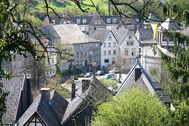
Kornelimünster/Walheim (Kornelimünster/Walheim (Stadtbezirk))
 Hiking in Kornelimünster/Walheim
Kornelimünster-Walheim is a picturesque area located near Aachen in Germany, known for its beautiful landscapes and charming village ambiance. Hiking in this region can be a delightful experience, offering a variety of trails that wind through lush forests, rolling hills, and serene meadows. Here are some highlights and tips for hiking in this area:
Hiking Trails
-
Historical Trails: The region often features paths that connect historical sites. You may encounter old churches, castles, and traditional houses that reflect the area's rich cultural heritage.
-
Nature Trails: The trails usually pass through scenic natural areas, showcasing diverse flora and fauna. Look out for local wildlife and take in the beautiful countryside vistas.
-
Circular Routes: Many trails in Kornelimünster-Walheim are circular, making it convenient to explore without the worry of retracing steps. These routes can range from easy to moderate in difficulty, catering to a wide range of hiking enthusiasts.
Recommended Areas
- Kornelimünster Abbey: The abbey area can be an intriguing starting point for hikes. The surroundings provide a peaceful atmosphere with beautiful views and gardens.
- Walheim’s Countryside: The village of Walheim offers scenic routes that take you through fields and forests, allowing you to immerse yourself in nature while enjoying the tranquility of the countryside.
Practical Tips
- Weather Check: Always check the weather forecast before heading out, as conditions can change quickly.
- Appropriate Gear: Wear sturdy hiking boots and dress in layers to accommodate changes in temperature, especially if you plan to hike for several hours.
- Hydration and Snacks: Bring plenty of water and some snacks to keep your energy up during the hike.
- Maps and Guides: It’s advisable to obtain a detailed map of the area or use a hiking app to navigate the trails effectively.
Local Amenities
- Cafés and Restaurants: After your hike, consider stopping by local cafés or restaurants in Kornelimünster or Walheim to enjoy some regional cuisine or a refreshing drink.
- Transportation: The area is accessible by public transport, so check local schedules for bus or train services that can take you to the hiking starting points.
Overall, hiking in Kornelimünster-Walheim is an enjoyable way to experience the natural beauty and cultural heritage of this charming region.
- Страна:

- Почтовый код: 52076
- Телефонный код: 02408
- Координаты: 50° 43' 17" N, 6° 10' 49" E


- GPS треки (wikiloc): [Ссылка]
- Высота над уровнем моря: 240 м m
- Площадь: 37.03 кв.км
- Википедия английская: wiki(en)
- Википедия национальная: wiki(de)
- Хранилище Wikidata: Wikidata: Q2563710
- код Freebase: [/m/0xn9yb8]
- ID отношения в OpenStreetMap: [21912]
- код Historical Gazetteer: [object_263607]
Включает регионы:
Friesenrath
Hiking in Friesenrath
Friesenrath is a small village in the North Rhine-Westphalia region of Germany, nestled in the picturesque landscape of the Eifel and surrounding areas. While it may not be as widely known as some of the larger hiking destinations in Germany, it offers access to beautiful countryside and scenic trails....
- Страна:
- Почтовый код: 52076
- Телефонный код: 02408
- Координаты: 50° 41' 40" N, 6° 11' 1" E
- GPS треки (wikiloc): [Ссылка]
- Высота над уровнем моря: 281 м m
Kornelimünster
Hiking in Kornelimünster
Kornelimünster, a picturesque village located near Aachen in Germany, is known for its beautiful landscape, rich history, and scenic hiking trails. The area is surrounded by lush forests, rolling hills, and charming farmland, making it a great destination for outdoor enthusiasts....
- Страна:
- Почтовый код: 52076
- Телефонный код: 02408
- Координаты: 50° 43' 43" N, 6° 10' 41" E
- GPS треки (wikiloc): [Ссылка]
- Высота над уровнем моря: 235 м m
- Площадь: 4.48 кв.км
Hahn
Hiking in Hahn
Hiking in Hahn, near Aachen, offers a beautiful blend of nature and scenic landscapes. The region is part of the Eifel area, known for its rolling hills, lush forests, and picturesque valleys. Here are some details to enhance your hiking experience in Hahn and the surrounding region:...
- Страна:
- Почтовый код: 52076
- Телефонный код: 02408
- Координаты: 50° 42' 41" N, 6° 11' 53" E
- GPS треки (wikiloc): [Ссылка]
- Высота над уровнем моря: 247 м m
Sief
Hiking in Sief
Sief, a picturesque trail region, is known for its scenic beauty and diverse hiking opportunities. While I don't have specific, detailed information about "Sief" as a hiking destination, it could refer to various locations depending on the region or country you're interested in....
- Страна:
- Почтовый код: 52076
- Телефонный код: 02408
- Координаты: 50° 41' 34" N, 6° 8' 24" E
- GPS треки (wikiloc): [Ссылка]
Oberforstbach
Hiking in Oberforstbach
Oberforstbach, located in the picturesque Eifel region of Germany, offers a variety of hiking opportunities set amidst beautiful natural landscapes. The area is characterized by its rolling hills, dense forests, and charming villages, making it an ideal destination for outdoor enthusiasts....
- Страна:
- Почтовый код: 52076
- Телефонный код: 02408
- Координаты: 50° 43' 25" N, 6° 8' 40" E
- GPS треки (wikiloc): [Ссылка]
- Высота над уровнем моря: 279 м m
Krauthausen
Hiking in Krauthausen
Krauthausen, located near Aachen in Germany, is surrounded by beautiful landscapes, making it a delightful spot for hiking enthusiasts. The area features a mix of hilly terrain, lush forests, and scenic views, providing a variety of trails suitable for different skill levels....
- Страна:
- Почтовый код: 52076
- Телефонный код: 02408
- Координаты: 50° 44' 29" N, 6° 11' 14" E
- GPS треки (wikiloc): [Ссылка]
- Высота над уровнем моря: 244 м m
Nütheim
Hiking in Nütheim
Nütheim is not widely recognized as a specific hiking destination in popular hiking guides or resources, but it could refer to a smaller locality or region that may have some hiking opportunities. If you could provide a bit more context—such as the country or region you're referring to—I can give you more targeted information about potential hiking trails, landscapes, and tips for that area!...
- Страна:
- Почтовый код: 52076
- Телефонный код: 02408
- Координаты: 50° 42' 55" N, 6° 9' 50" E
- GPS треки (wikiloc): [Ссылка]
- Население: 175

Lichtenbusch
Hiking in Lichtenbusch
Lichtenbusch is a small village located near the border of Belgium and Germany, part of the municipality of Eupen in the German-speaking community of Belgium. While it may not be as renowned as some larger hiking destinations, Lichtenbusch offers some beautiful landscapes and hiking opportunities. Here are some key points to consider about hiking in the area:...
- Страна:
- Почтовый код: 52076
- Телефонный код: 02408
- Координаты: 50° 42' 48" N, 6° 7' 30" E
- GPS треки (wikiloc): [Ссылка]
- Высота над уровнем моря: 290 м m
Schleckheim
Hiking in Schleckheim
Schleckheim is a small, picturesque area that offers a variety of hiking opportunities, particularly for those seeking a tranquil and scenic outdoor experience. When hiking in Schleckheim, consider the following aspects:...
- Страна:
- Почтовый код: 52076
- Телефонный код: 02408
- Координаты: 50° 43' 12" N, 6° 9' 18" E
- GPS треки (wikiloc): [Ссылка]
- Высота над уровнем моря: 280 м m
Walheim
Hiking in Walheim
Walheim, a quaint village near Aachen in Germany, serves as a great starting point for various hiking adventures in the surrounding region. The area is characterized by its picturesque landscapes, rolling hills, and lush forests, which make it ideal for outdoor enthusiasts....
- Страна:
- Почтовый код: 52076
- Телефонный код: 02408
- Координаты: 50° 42' 26" N, 6° 10' 57" E
- GPS треки (wikiloc): [Ссылка]
- Высота над уровнем моря: 277 м m