Küblis (Kreis Küblis)
 Hiking in Küblis
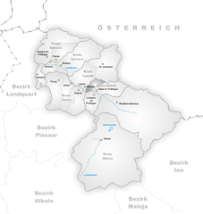
Kreis Küblis, located in the canton of Graubünden in Switzerland, offers a beautiful landscape and a variety of hiking opportunities for all levels of outdoor enthusiasts. The region is known for its stunning alpine scenery, charming villages, and diverse ecosystems, making it a great destination for hiking.
Hiking Trails
-
Difficulty Levels: You can find hikes ranging from easy, family-friendly walks to challenging alpine routes. The well-marked trails cater to both casual hikers and seasoned adventurers.
-
Popular Routes:
- Küblis to Pany: This is a relatively easy hike that offers beautiful views of the surrounding mountains and valleys. The trail passes through lush meadows and quaint villages.
- Grüsch to Fälden: This slightly more challenging route provides stunning views of the Prättigau valley. The trail includes some elevation gain and can be a rewarding experience.
- High-altitude Trails: For more experienced hikers, trails leading towards the mountain peaks around Küblis offer breathtaking panoramic views and the chance to see local wildlife.
Seasonal Considerations
-
Summer: Summer is the prime season for hiking, with trails clear of snow and wildflowers blooming. The weather is generally warm, but it's wise to check the forecast as conditions can change quickly in the mountains.
-
Autumn: Fall offers stunning foliage and a quieter hiking experience. Temperatures start to drop, so layer your clothing to stay comfortable.
-
Winter: Some trails may be suitable for snowshoeing or winter hikes, but always check local conditions and trail openings.
Essential Tips
-
Preparation: Always carry a map, sufficient water, snacks, and a first-aid kit. Check the weather forecast and trail conditions before setting out.
-
Navigation: While many trails are well-marked, having a GPS or a hiking app can help you navigate, particularly in the more remote areas.
-
Leave No Trace: Respect the environment by following Leave No Trace principles, including packing out what you pack in and staying on marked trails.
Local Resources
-
Visitor Centers: Local tourist information centers can provide valuable insights about trail conditions, recommended routes, and any safety advisories.
-
Guided Tours: If you're unfamiliar with the area or want a more in-depth experience, consider joining a guided hike.
Hiking in Kreis Küblis can be a rewarding adventure filled with breathtaking nature and the tranquility of the Swiss Alps. Enjoy exploring the trails!
- Страна:

- Хранилище Wikidata: Wikidata: Q681403
- Катеория в википедии: [Ссылка]
Включает регионы:

Кюблис
Hiking in Кюблис
Küblis, located in the Prättigau region of Switzerland, is a lovely spot for hiking enthusiasts. Nestled between the mountains and close to the Landquart River, this area offers a variety of trails that cater to different skill levels, from easy walks to more challenging hikes....
- Страна:
- Почтовый код: 7240
- Телефонный код: 081
- Код автомобильного номера: GR
- Координаты: 46° 54' 53" N, 9° 46' 27" E


- GPS треки (wikiloc): [Ссылка]
- Высота над уровнем моря: 814 м m
- Площадь: 8.14 кв.км
- Население: 853
- Веб сайт: [Ссылка]


Зас
Hiking in Зас
Saas im Prättigau is a fantastic destination for hiking enthusiasts, nestled in the stunning Prättigau region of the Swiss Alps. Here are some key points to consider about hiking in this area:...
- Страна:
- Почтовый код: 7247
- Телефонный код: 081
- Код автомобильного номера: GR
- Координаты: 46° 54' 59" N, 9° 47' 59" E
- GPS треки (wikiloc): [Ссылка]
- Высота над уровнем моря: 988 м m
- Площадь: 26.71 кв.км
- Веб сайт: [Ссылка]


Контерс
Hiking in Контерс
Conters im Prättigau is a charming village located in the Graubünden region of Switzerland, surrounded by stunning natural landscapes and offering various hiking opportunities. Here are some key points to consider when planning your hiking adventure in and around Conters:...
- Страна:
- Почтовый код: 7241
- Телефонный код: 081
- Код автомобильного номера: GR
- Координаты: 46° 53' 59" N, 9° 47' 0" E
- GPS треки (wikiloc): [Ссылка]
- Высота над уровнем моря: 1110 м m
- Площадь: 18.40 кв.км
- Население: 225
- Веб сайт: [Ссылка]