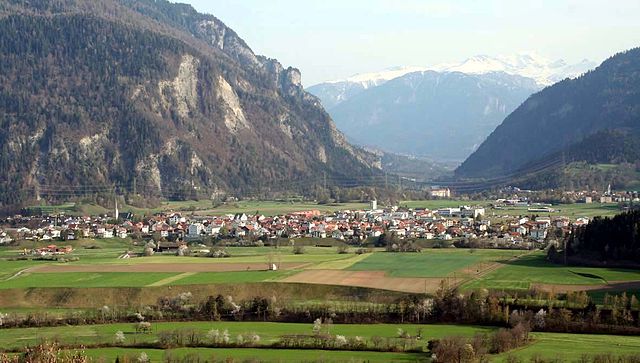
Rhäzüns (Kreis Rhäzüns)
 Hiking in Rhäzüns
Kreis Rhäzüns, located in the canton of Graubünden in Switzerland, offers a stunning array of hiking opportunities for both beginners and experienced hikers. The region is characterized by its breathtaking landscapes, including majestic mountains, lush valleys, and scenic rivers. Here are some notable aspects of hiking in this area:
Scenic Trails
-
Rhaetian Railway Trail: This trail offers a unique perspective as it follows the route of the famous Rhaetian Railway. Hikers can enjoy a leisurely walk with fascinating views of the train traveling through the picturesque landscape.
-
Arosa-Lenzerheide Area: Close to Rhäzüns, this area has numerous well-marked trails ranging from easy walks to challenging hikes, offering panoramic views of the Alps.
-
Vorderrhein Valley: Explore the stunning Vorderrhein Gorge, where the contrasts of the rock formations along the river create an unforgettable hiking experience.
Nature and Wildlife
The region is home to diverse flora and fauna. Hikers might encounter a variety of alpine plants and possibly catch a glimpse of wildlife such as ibex and chamois. Birdwatching opportunities abound as well, with many species inhabiting the alpine environments.
Accessibility
The region is well-connected by public transport, making it easier for hikers to access the starting points of various trails. Local guides and tours are also available for those looking for a more structured experience.
Seasonal Considerations
- Summer: Ideal for hiking, with trails fully accessible and wildflowers in bloom.
- Autumn: The fall colors provide a stunning backdrop for hikes.
- Winter: Some trails offer snowshoeing opportunities, and skiing is popular in nearby areas.
Tips for Hikers
- Hydration: Always carry enough water, especially during summer hikes.
- Navigation: Use a reliable map or a GPS device, as some trails may not be well-marked.
- Clothing: Wear layers to adapt to changing weather conditions, and sturdy hiking boots are recommended.
- Respect Nature: Follow the Leave No Trace principles to help preserve the natural beauty of the area.
Whether you're looking for a short day hike or an overnight backpacking adventure, Kreis Rhäzüns has a lot to offer for outdoor enthusiasts. Enjoy your hiking!
- Страна:

- Хранилище Wikidata: Wikidata: Q685365
- Катеория в википедии: [Ссылка]
- идентификатор HDS: [8080]
Включает регионы:

Бонадуц
Hiking in Бонадуц
Bonaduz, located in the Grisons region of Switzerland, is an excellent destination for hiking enthusiasts. The area is characterized by its stunning natural landscapes, including the surrounding mountains, lush forests, and scenic rivers....
- Страна:
- Почтовый код: 7402
- Телефонный код: 081
- Код автомобильного номера: GR
- Координаты: 46° 48' 19" N, 9° 22' 15" E


- GPS треки (wikiloc): [Ссылка]
- Высота над уровнем моря: 743 м m
- Площадь: 14.40 кв.км
- Население: 3294
- Веб сайт: [Ссылка]


Рецюнс
Hiking in Рецюнс
Rhäzüns is a beautiful municipality located in the Graubünden region of Switzerland, surrounded by stunning landscapes and offering excellent hiking opportunities. The area is characterized by its picturesque mountains, dense forests, and lovely meadows, making it a fantastic destination for outdoor enthusiasts....
- Страна:
- Почтовый код: 7403
- Телефонный код: 081
- Код автомобильного номера: GR
- Координаты: 46° 47' 59" N, 9° 23' 59" E
- GPS треки (wikiloc): [Ссылка]
- Высота над уровнем моря: 657 м m
- Площадь: 13.37 кв.км
- Население: 1494
- Веб сайт: [Ссылка]


Домат-Эмс
Hiking in Домат-Эмс
Domat/Ems is a picturesque village located in the canton of Graubünden, Switzerland. Surrounded by stunning mountain landscapes and lush forests, it offers a variety of hiking opportunities for all levels of experience. Here are some highlights and tips for hiking in and around Domat/Ems:...
- Страна:
- Почтовый код: 7013
- Телефонный код: 081
- Код автомобильного номера: GR
- Координаты: 46° 49' 11" N, 9° 27' 16" E
- GPS треки (wikiloc): [Ссылка]
- Высота над уровнем моря: 991 м m
- Площадь: 24.22 кв.км
- Население: 8070
- Веб сайт: [Ссылка]