Л’Эскарен (L'Escarène, L'Escarène)

- коммуна в департаменте Приморские Альпы, регион Прованс — Альпы — Лазурный Берег, Франция
 Hiking in Л’Эскарен
L'Escarène is a charming village located in the Alpes-Maritimes department in southeastern France, nestled in the beautiful hills of the Côte d'Azur. The area around L'Escarène offers a variety of hiking opportunities, characterized by its picturesque landscapes, stunning views of the surrounding hills and valleys, and proximity to the Mediterranean coastline.
Hiking Highlights in L'Escarène:
-
Scenic Trails: The region has numerous trails suitable for all hiking levels, ranging from easy walks for families to more challenging routes for experienced hikers. Many trails feature beautiful views of the surrounding countryside, vineyards, and historic sites.
-
Natural Parks: L'Escarène is close to the Parc Naturel Régional des Préalpes d'Azur, which provides a network of hiking paths that allow you to experience diverse flora and fauna native to the region.
-
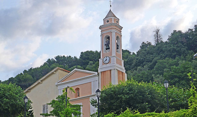
Cultural Exploration: Hiking in and around L'Escarène also offers the chance to discover local heritage. The area features traditional stone houses, narrow alleyways, and historical landmarks, making it an opportunity for both nature and culture enthusiasts.
-
Popular Hikes: Some popular hikes in the area include:
- Le Mont Marché: A moderately challenging hike that provides spectacular views from the summit.
- Sentier de la Manda: An easier hike ideal for families, which includes beautiful landscapes and leads to old ruins.
- GR51 (Sentier de Grande Randonnée 51): This long-distance trail passes through L'Escarène and offers breathtaking views of the Mediterranean coast.
-
Best Time to Hike: The best hiking seasons in L'Escarène are typically spring (April to June) and fall (September to November) when the weather is mild, and the landscape is vibrant. Summers can be hot, while winters may see occasional snow in higher elevations.
Precautions:
- Safety: Always check the weather before heading out, inform someone of your hiking plans, and carry sufficient water, snacks, and a map.
- Trail Conditions: Some trails may be more rugged than others, so wear appropriate footwear and consider your fitness level when choosing a hike.
Conclusion:
Hiking in L'Escarène offers a wonderful blend of nature, culture, and stunning views. Whether you are seeking a leisurely stroll or a challenging hike, you’ll find plenty to explore. Don't forget to take your camera to capture the beautiful landscapes!
- Страна:

- Почтовый код: 06440
- Координаты: 43° 50' 4" N, 7° 21' 24" E


- GPS треки (wikiloc): [Ссылка]
- Площадь: 10.67 кв.км
- Население: 2507
- Википедия русская: wiki(ru)
- Википедия английская: wiki(en)
- Википедия национальная: wiki(fr)
- Хранилище Wikidata: Wikidata: Q1002059
- Катеория в википедии: [Ссылка]
- код Freebase: [/m/08nbff]
- код Freebase: [/m/08nbff]
- код GeoNames: Альт: [3001613]
- код GeoNames: Альт: [3001613]
- номер SIREN: [210600573]
- номер SIREN: [210600573]
- код VIAF: Альт: [235580568]
- код VIAF: Альт: [235580568]
- WOEID: [596520]
- WOEID: [596520]
- код муниципалитета INSEE: 06057
- код муниципалитета INSEE: 06057
Граничит с регионами:

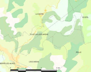
Туэ-де-л’Эскарен
- коммуна в департаменте Приморские Альпы, регион Прованс — Альпы — Лазурный Берег, Франция
Hiking in Туэ-де-л’Эскарен
Touët-de-l'Escarène is a charming village located in the Alpes-Maritimes department of France, not far from Nice. It serves as a great base for hiking enthusiasts looking to explore the scenic beauty of the surrounding regions. Here’s what you should know about hiking around Touët-de-l'Escarène:...
- Страна:
- Почтовый код: 06440
- Координаты: 43° 50' 51" N, 7° 21' 54" E
- GPS треки (wikiloc): [Ссылка]
- Высота над уровнем моря: 415 м m
- Площадь: 4.57 кв.км
- Население: 289

Блозаск
- коммуна в департаменте Приморские Альпы, регион Прованс — Альпы — Лазурный Берег, Франция
Hiking in Блозаск
Blausasc is a charming village located in the Alpes-Maritimes department of France, near Nice. It is known for its stunning landscapes and diverse hiking opportunities, making it a great destination for outdoor enthusiasts....
- Страна:
- Почтовый код: 06440
- Координаты: 43° 48' 17" N, 7° 21' 55" E
- GPS треки (wikiloc): [Ссылка]
- Площадь: 10.21 кв.км
- Население: 1448


Бер-лез-Альп
- коммуна в департаменте Приморские Альпы, регион Прованс — Альпы — Лазурный Берег, Франция
Hiking in Бер-лез-Альп
Berre-les-Alpes is a charming village located in the hills near Nice in the French Riviera, offering stunning views and diverse hiking opportunities. Here are some key points about hiking in and around Berre-les-Alpes:...
- Страна:
- Почтовый код: 06390
- Координаты: 43° 49' 49" N, 7° 19' 44" E
- GPS треки (wikiloc): [Ссылка]
- Площадь: 9.58 кв.км
- Население: 1270


Люсерам
- коммуна в департаменте Приморские Альпы, регион Прованс — Альпы — Лазурный Берег, Франция
Hiking in Люсерам
Lucéram is a picturesque village located in the Alpes-Maritimes department of France, nestled in the hills of Provence near the French Riviera. The area surrounding Lucéram offers a variety of hiking opportunities, showcasing stunning landscapes, rich flora, and charming rural architecture....
- Страна:
- Почтовый код: 06440
- Координаты: 43° 52' 57" N, 7° 21' 38" E
- GPS треки (wikiloc): [Ссылка]
- Площадь: 65.52 кв.км
- Население: 1261

Пей
- коммуна в департаменте Приморские Альпы, регион Прованс — Альпы — Лазурный Берег, Франция
Hiking in Пей
Peille is a charming village located in the Alpes-Maritimes department in the Provence-Alpes-Côte d'Azur region of France. Nestled in the hills above the Mediterranean, it offers a variety of hiking opportunities with stunning views, lush vegetation, and a rich history....
- Страна:
- Почтовый код: 06440
- Координаты: 43° 48' 9" N, 7° 24' 6" E
- GPS треки (wikiloc): [Ссылка]
- Площадь: 43.16 кв.км
- Население: 2353
- Веб сайт: [Ссылка]