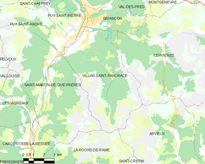
Ла-Рош-де-Рам (La Roche-de-Rame, La Roche-de-Rame)
- коммуна во Франции
 Hiking in Ла-Рош-де-Рам
La Roche-de-Rame is a picturesque commune located in the Hautes-Alpes department in southeastern France. It is nestled in the stunning French Alps, providing a perfect backdrop for hiking enthusiasts. Here are some key points to consider if you're planning a hiking trip to La Roche-de-Rame:
Scenic Trails
- Varied Terrain: The area features a mix of terrain, from gentle valleys to rugged mountains, offering hikes suitable for all skill levels.
- Alpine Flora and Fauna: As you hike, you can expect to encounter diverse plant species and possibly see wildlife such as chamois and mountain birds.
- Breathtaking Views: Many trails offer stunning views of the surrounding peaks and valleys, making them excellent for photography and nature appreciation.
Popular Hikes
- Lac de l'Eychauda: This is a popular hike leading to a beautiful mountain lake surrounded by spectacular landscapes.
- Col de l'Autaret: A more challenging hike that rewards you with panoramic views of the region.
- Sentier du Patrimoine: An easier trail that takes you through historical sites and offers insight into the local culture and environment.
Practical Information
- Access: La Roche-de-Rame is accessible by car and is well connected to nearby towns and cities.
- Best Time to Visit: Late spring to early autumn is ideal for hiking, as the weather is generally mild and the trails are accessible.
- Safety: Always check the weather conditions before heading out, and make sure to wear appropriate gear and carry enough water and snacks.
Local Amenities
- Accommodations: There are various options from hotels to guesthouses available in La Roche-de-Rame and the surrounding areas.
- Guided Tours: If you’re not familiar with the area or prefer hiking with a guide, local tour companies offer organized hikes.
Conclusion
Hiking in La Roche-de-Rame provides a fantastic opportunity to immerse yourself in the natural beauty of the French Alps. Whether you're a seasoned hiker or a beginner, there are trails that can accommodate your skill level, ensuring an enjoyable and memorable outdoor experience. Always remember to follow Leave No Trace principles to preserve the area's natural beauty for future visitors.
- Страна:

- Почтовый код: 05310
- Координаты: 44° 45' 0" N, 6° 34' 50" E


- GPS треки (wikiloc): [Ссылка]
- Площадь: 40.53 кв.км
- Население: 837
- Википедия русская: wiki(ru)
- Википедия английская: wiki(en)
- Википедия национальная: wiki(fr)
- Хранилище Wikidata: Wikidata: Q1085923
- Катеория в википедии: [Ссылка]
- код Freebase: [/m/03mfpdm]
- код Freebase: [/m/03mfpdm]
- код GeoNames: Альт: [3006797]
- код GeoNames: Альт: [3006797]
- номер SIREN: [210501227]
- номер SIREN: [210501227]
- код тезауруса PACTOLS: [pcrtN8IoZeZ9Yo]
- код тезауруса PACTOLS: [pcrtN8IoZeZ9Yo]
- WOEID: [15003283]
- WOEID: [15003283]
- код муниципалитета INSEE: 05122
- код муниципалитета INSEE: 05122
Граничит с регионами:
Шанселла
- коммуна во Франции
Hiking in Шанселла
Champcella is a lesser-known but beautiful hiking destination located in the French Alps, specifically in the Isère department. It's an excellent spot for nature lovers and those seeking adventure in mountain landscapes. Here are some key aspects to consider when hiking in Champcella:...
- Страна:
- Почтовый код: 05310
- Координаты: 44° 43' 22" N, 6° 34' 17" E
- GPS треки (wikiloc): [Ссылка]
- Высота над уровнем моря: 1150 м m
- Площадь: 30.25 кв.км
- Население: 182

Арвьё
- коммуна во Франции
Hiking in Арвьё
Arvieux is a stunning destination situated in the Queyras Regional Natural Park in the French Alps, known for its beautiful landscapes, charming villages, and numerous hiking trails. Here are some highlights and tips for hiking in Arvieux:...
- Страна:
- Почтовый код: 05350
- Координаты: 44° 46' 0" N, 6° 44' 20" E
- GPS треки (wikiloc): [Ссылка]
- Площадь: 72.62 кв.км
- Население: 363

Сен-Крепен
- коммуна во Франции
Hiking in Сен-Крепен
Saint-Crépin is a charming village located in the Hautes-Alpes region of southeastern France. Nestled in the beautiful Southern Alps, it offers a range of hiking opportunities that take advantage of its stunning natural surroundings....
- Страна:
- Почтовый код: 05600
- Координаты: 44° 42' 24" N, 6° 36' 26" E
- GPS треки (wikiloc): [Ссылка]
- Площадь: 46.3 кв.км
- Население: 703
- Веб сайт: [Ссылка]

Фрессиньер
- коммуна во Франции
Hiking in Фрессиньер
Freissinières is a picturesque village located in the Écrins National Park in the French Alps, renowned for its stunning landscapes, rich biodiversity, and a variety of hiking opportunities. Here's an overview to help you make the most of your hiking experience in Freissinières:...
- Страна:
- Почтовый код: 05310
- Координаты: 44° 45' 15" N, 6° 32' 14" E
- GPS треки (wikiloc): [Ссылка]
- Высота над уровнем моря: 1190 м m
- Площадь: 88.21 кв.км
- Население: 208
- Веб сайт: [Ссылка]

Сен-Мартен-де-Кейриер
- коммуна во Франции
Hiking in Сен-Мартен-де-Кейриер
Saint-Martin-de-Queyrières is a charming village located in the Hautes-Alpes region of France. It's a fantastic starting point for hiking enthusiasts as it offers access to stunning landscapes, diverse trails, and beautiful views of the Écrins National Park and surrounding mountains. Here are some highlights regarding hiking in this area:...
- Страна:
- Почтовый код: 05120
- Координаты: 44° 50' 25" N, 6° 35' 7" E
- GPS треки (wikiloc): [Ссылка]
- Высота над уровнем моря: 1200 м m
- Площадь: 55.52 кв.км
- Население: 1131

Л’Аржантьер-ла-Бессе
- коммуна во Франции
Hiking in Л’Аржантьер-ла-Бессе
L'Argentière-la-Bessée, located in the Hautes-Alpes region of France, is a picturesque village surrounded by stunning mountain ranges, making it a fantastic destination for hiking enthusiasts. Here are some highlights and tips for hiking in this area:...
- Страна:
- Почтовый код: 05120
- Координаты: 44° 47' 40" N, 6° 33' 33" E
- GPS треки (wikiloc): [Ссылка]
- Площадь: 64.55 кв.км
- Население: 2307

Виллар-Сен-Панкрас
- коммуна во Франции
Hiking in Виллар-Сен-Панкрас
Villar-Saint-Pancrace is a charming alpine village located in the Provence-Alpes-Côte d'Azur region of France, near the town of Briançon. The area is known for its stunning landscapes, rich biodiversity, and a variety of hiking trails that cater to different skill levels. Here are some highlights for hiking in this region:...
- Страна:
- Почтовый код: 05100
- Координаты: 44° 52' 23" N, 6° 37' 38" E
- GPS треки (wikiloc): [Ссылка]
- Высота над уровнем моря: 1260 м m
- Площадь: 42.53 кв.км
- Население: 1457