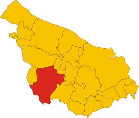
Латиано (Latiano, Latiano)
.svg)
- коммуна Италии
 Hiking in Латиано
Latiano, a charming town located in the Apulia region of southern Italy, is surrounded by a landscape that offers some potential for hiking and outdoor activities. While it may not be a well-known hiking destination, there are several options to explore the natural beauty and historical sites in the area.
Hiking Opportunities in and Around Latiano:
-
Countryside Trails:
- The area around Latiano features picturesque countryside with olive groves, vineyards, and farmland. You can find various trails that allow you to enjoy the tranquility of the Apulian landscape.
-
Nature Reserves:
- Nearby, you can explore nature reserves or parks in the region, like the Parco Naturale Regionale Dune Costiere, which is located along the Adriatic coast. While this may require a short drive from Latiano, it offers beautiful coastal trails and diverse flora and fauna.
-
Historical Sites:
- Combining hiking with cultural exploration is another option. You can hike to nearby historical landmarks, such as ancient towns and churches, and enjoy the rich culture of the region.
-
Local Communities:
- Engaging with local community events or guided tours might offer organized hikes, especially during the spring and fall when the weather is ideal for outdoor activities.
Tips for Hiking in the Latiano Area:
- Weather Considerations: The best times for hiking in this region are spring (April to June) and fall (September to November) when the temperatures are mild.
- Local Maps and Guides: Consider obtaining local hiking maps or joining guided tours to better navigate the area and learn about its history and ecology.
- Stay Hydrated and Equipped: As always, carry plenty of water, wear good hiking shoes, and have sun protection, especially if hiking in open areas.
Conclusion:
While Latiano itself may not be a prominent hiking destination, its surrounding landscapes and opportunities for outdoor exploration can provide a fulfilling experience for hiking enthusiasts. With a spirit of adventure and a bit of exploration, you can uncover the beauty of this charming part of Italy.
- Страна:

- Почтовый код: 72022
- Телефонный код: 0831
- Код автомобильного номера: BR
- Координаты: 40° 32' 0" N, 17° 43' 0" E


- GPS треки (wikiloc): [Ссылка]
- Высота над уровнем моря: 97 м m
- Площадь: 54.78 кв.км
- Население: 14403
- Веб сайт: http://www.comune.latiano.br.it/
- Википедия русская: wiki(ru)
- Википедия английская: wiki(en)
- Википедия национальная: wiki(it)
- Хранилище Wikidata: Wikidata: Q51867
- Катеория в википедии: [Ссылка]
- код Freebase: [/m/0f5l1f]
- код GeoNames: Альт: [6537575]
- код VIAF: Альт: [138474710]
- ID отношения в OpenStreetMap: [40597]
- код GND: Альт: [4445523-9]
- код темы Quora: [Latiano]
- UN/LOCODE: [ITLAT]
- код ISTAT: 074009
- кадастровый код Италии: E471
Граничит с регионами:


Бриндизи
- коммуна Италии
Hiking in Бриндизи
Brindisi, located in the Apulia region of southern Italy, offers a variety of hiking opportunities that showcase its beautiful landscapes, coastal scenery, and historical sites. Here are some key hiking spots and experiences in and around Brindisi:...
- Страна:
- Почтовый код: 72100
- Телефонный код: 0831
- Код автомобильного номера: BR
- Координаты: 40° 38' 18" N, 17° 56' 45" E
- GPS треки (wikiloc): [Ссылка]
- Высота над уровнем моря: 15 м m
- Площадь: 332.98 кв.км
- Население: 88126
- Веб сайт: [Ссылка]

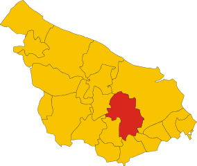
Франкавилла-Фонтана
- коммуна Италии
Hiking in Франкавилла-Фонтана
Francavilla Fontana is a town in the Apulia region of southern Italy, rich in history and culture, and surrounded by beautiful natural landscapes that can provide a great hiking experience. While Francavilla Fontana itself is more known for its architecture and historical sites, its surrounding areas offer opportunities for outdoor activities....
- Страна:
- Почтовый код: 72021
- Телефонный код: 0831
- Код автомобильного номера: BR
- Координаты: 40° 31' 53" N, 17° 35' 9" E
- GPS треки (wikiloc): [Ссылка]
- Высота над уровнем моря: 142 м m
- Площадь: 177.94 кв.км
- Население: 36358
- Веб сайт: [Ссылка]

Мезанье
- коммуна Италии
Hiking in Мезанье
Mesagne, located in the Apulia region of Italy, is not typically known as a primary hiking destination like some of the larger national parks or mountainous areas, but it offers a unique opportunity for those interested in exploring the picturesque landscapes of the Salento region....
- Страна:
- Почтовый код: 72023
- Телефонный код: 0831
- Код автомобильного номера: BR
- Координаты: 40° 34' 0" N, 17° 48' 0" E
- GPS треки (wikiloc): [Ссылка]
- Высота над уровнем моря: 72 м m
- Площадь: 124.05 кв.км
- Население: 26836
- Веб сайт: [Ссылка]


Ория
- коммуна Италии
Hiking in Ория
Oria, located in the Apulia region of Italy, is a charming town rich in history and surrounded by beautiful landscapes ideal for hiking enthusiasts. While Oria itself is known for its historical architecture, including the majestic castle and ancient churches, the surrounding countryside offers a variety of trails showcasing the natural beauty of the region....
- Страна:
- Почтовый код: 72024
- Телефонный код: 0831
- Код автомобильного номера: BR
- Координаты: 40° 30' 0" N, 17° 38' 0" E
- GPS треки (wikiloc): [Ссылка]
- Высота над уровнем моря: 83 м m
- Площадь: 83.67 кв.км
- Население: 15094
- Веб сайт: [Ссылка]
Сан-Микеле-Салентино
- коммуна Италии
Hiking in Сан-Микеле-Салентино
San Michele Salentino is a charming town located in the Apulia (Puglia) region of Italy, known for its picturesque landscapes, historical sites, and traditional olive groves. While it may not be as famous for hiking as other regions in Italy, it offers some lovely opportunities for walking and exploring the countryside....
- Страна:
- Почтовый код: 72018
- Телефонный код: 0831
- Код автомобильного номера: BR
- Координаты: 40° 38' 0" N, 17° 38' 0" E
- GPS треки (wikiloc): [Ссылка]
- Высота над уровнем моря: 153 м m
- Площадь: 26.53 кв.км
- Население: 6258
- Веб сайт: [Ссылка]


Сан-Вито-деи-Норманни
- коммуна Италии
Hiking in Сан-Вито-деи-Норманни
San Vito dei Normanni, located in the Apulia region of southern Italy, is a charming town known for its beautiful landscapes, rich history, and traditional architecture. While it may not be as famous for hiking as some other regions in Italy, there are still opportunities for outdoor enthusiasts to explore the surrounding countryside and enjoy the natural beauty of the area....
- Страна:
- Почтовый код: 72019
- Телефонный код: 0831
- Код автомобильного номера: BR
- Координаты: 40° 39' 20" N, 17° 42' 13" E
- GPS треки (wikiloc): [Ссылка]
- Высота над уровнем моря: 108 м m
- Площадь: 67.08 кв.км
- Население: 19095
- Веб сайт: [Ссылка]