Лауфенбург (Laufenburg District, Bezirk Laufenburg)

 Hiking in Лауфенбург
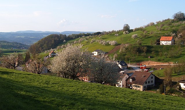
Laufenburg District, located in the canton of Aargau in Switzerland, is a hidden gem for hikers and nature enthusiasts. The area is characterized by its picturesque landscapes, charming small towns, and varied terrain, making it an ideal destination for hiking. Here are some highlights and tips for hiking in the Laufenburg District:
Scenic Trails
-
River Trails: The district is bordered by the Rhine River, which offers beautiful flat trails for leisurely hikes along the riverbanks. These trails provide stunning views of the water and the surrounding countryside.
-
Forest Paths: The region is dotted with lush forests, particularly in the surrounding hills. Trails through these wooded areas often lead to tranquil spots perfect for a picnic or enjoying nature.
-
Panoramic Views: For those willing to tackle higher elevations, there are trails that lead to viewpoints where you can enjoy breathtaking panoramas of the Rhine Valley and the Swiss Alps on clear days.
Marked Trails
The hiking trails in Laufenburg are typically well-marked and maintained. Look for signs posted by the Swiss Hiking Federation, which highlight various routes suitable for different skill levels.
Towns and Attractions
-
Laufenburg: This quaint town, split between Switzerland and Germany by the Rhine, has lovely cobblestone streets and historical charm. It's a great place to start or end your hike and enjoy a meal or local cafés.
-
Schwarzbubenland: This area offers multiple hiking routes and is known for its diverse flora and fauna.
Difficulty Levels
The hiking trails range from easy walks to more challenging paths. It’s essential to choose a trail that matches your fitness level, especially if you’re hiking with children or inexperienced hikers.
Best Times to Hike
Spring and early autumn are ideal times for hiking in the Laufenburg District. The weather is generally mild, and the natural scenery is particularly beautiful during these seasons. Summer can be warm, but early morning or late afternoon hikes can still be enjoyable.
Safety and Preparation
- Always check the weather forecast before heading out.
- Make sure to wear appropriate footwear and bring enough water and snacks, particularly for longer hikes.
- A map or a hiking app can be helpful for navigation, especially if you're venturing off the main trails.
Whether you're looking for a short afternoon hike or a more extended trekking adventure, the Laufenburg District provides a wonderful opportunity to explore the beauty of Swiss nature. Happy hiking!
- Страна:

- Код автомобильного номера: AG
- Координаты: 47° 33' 0" N, 8° 3' 0" E


- GPS треки (wikiloc): [Ссылка]
- Высота над уровнем моря: 480 м m
- Площадь: 125.57 кв.км
- Википедия русская: wiki(ru)
- Википедия английская: wiki(en)
- Википедия национальная: wiki(de)
- Хранилище Wikidata: Wikidata: Q533676
- Катеория в википедии: [Ссылка]
- код Freebase: [/m/0fyxbx]
- код GeoNames: Альт: [6458860]
- идентификатор местоположения ArchINFORM: [5895]
- идентификатор HDS: [8523]
Включает регионы:

Зиссельн
Hiking in Зиссельн
Sisseln is a charming village located in the canton of Aargau, Switzerland, and it offers some lovely opportunities for hiking and enjoying the surrounding natural beauty. The area is characterized by picturesque landscapes, rolling hills, and well-marked trails that are suitable for hikers of all levels....
- Страна:
- Почтовый код: 4334
- Телефонный код: 062
- Код автомобильного номера: AG
- Координаты: 47° 33' 8" N, 7° 59' 7" E
- GPS треки (wikiloc): [Ссылка]
- Высота над уровнем моря: 292 м m
- Площадь: 2.52 кв.км
- Население: 1589
- Веб сайт: [Ссылка]
Айкен
Hiking in Айкен
Eiken, located in the Aargau region of Switzerland, offers a variety of hiking opportunities amidst picturesque landscapes. The area is characterized by rolling hills, forests, and charming Swiss villages, making it a great destination for both novice and experienced hikers....
- Страна:
- Почтовый код: 5074
- Телефонный код: 062
- Код автомобильного номера: AG
- Координаты: 47° 32' 14" N, 7° 59' 21" E
- GPS треки (wikiloc): [Ссылка]
- Высота над уровнем моря: 317 м m
- Площадь: 7.07 кв.км
- Население: 2277
- Веб сайт: [Ссылка]

Вёльфлинсвиль
Hiking in Вёльфлинсвиль
Wölflinswil, located in the Aargau region of Switzerland, offers a delightful experience for hikers and nature lovers. The area is characterized by its scenic landscapes, rolling hills, and lush greenery, making it an attractive destination for outdoor enthusiasts....
- Страна:
- Почтовый код: 5063
- Телефонный код: 062
- Код автомобильного номера: AG
- Координаты: 47° 27' 40" N, 7° 59' 52" E
- GPS треки (wikiloc): [Ссылка]
- Высота над уровнем моря: 455 м m
- Площадь: 9.51 кв.км
- Население: 1040
- Веб сайт: [Ссылка]

Икен
Hiking in Икен
Ueken is a small village located in the Canton of Aargau, Switzerland, known for its beautiful natural surroundings and scenic views. Hiking in Ueken offers a variety of trails suitable for different skill levels, ranging from easy walks to more challenging hikes. Here are some key points to consider when hiking in Ueken:...
- Страна:
- Почтовый код: 5028
- Телефонный код: 062
- Код автомобильного номера: AG
- Координаты: 47° 29' 7" N, 8° 2' 36" E
- GPS треки (wikiloc): [Ссылка]
- Высота над уровнем моря: 404 м m
- Площадь: 5.10 кв.км
- Население: 895
- Веб сайт: [Ссылка]

Фрик
Hiking in Фрик
Frick, located in the Aargau region of Switzerland, offers a range of hiking opportunities that cater to various skill levels and interests. The region is known for its picturesque landscapes, historical sites, and access to nature. Here are some highlights for hiking in Frick:...
- Страна:
- Почтовый код: 5070
- Телефонный код: 062
- Код автомобильного номера: AG
- Координаты: 47° 30' 29" N, 8° 1' 20" E
- GPS треки (wikiloc): [Ссылка]
- Высота над уровнем моря: 361 м m
- Площадь: 9.96 кв.км
- Население: 5550
- Веб сайт: [Ссылка]

Хорнуссен
Hiking in Хорнуссен
Hornussen, located in the Aargau region of Switzerland, offers picturesque landscapes and a range of hiking opportunities that cater to various skill levels. The area is characterized by its rolling hills, forests, and farmland, making it an ideal spot for nature lovers and outdoor enthusiasts....
- Страна:
- Почтовый код: 5075
- Телефонный код: 062
- Код автомобильного номера: AG
- Координаты: 47° 30' 4" N, 8° 3' 50" E
- GPS треки (wikiloc): [Ссылка]
- Высота над уровнем моря: 383 м m
- Площадь: 7.27 кв.км
- Население: 937
- Веб сайт: [Ссылка]
Цайэн
Hiking in Цайэн
Zeihen is a small village located in the canton of Aargau in Switzerland. It offers beautiful landscapes and access to scenic trails that are perfect for hiking enthusiasts. Here are some highlights and tips for hiking in Zeihen:...
- Страна:
- Почтовый код: 5079
- Телефонный код: 062
- Код автомобильного номера: AG
- Координаты: 47° 28' 14" N, 8° 5' 35" E
- GPS треки (wikiloc): [Ссылка]
- Высота над уровнем моря: 556 м m
- Площадь: 6.87 кв.км
- Население: 1169
- Веб сайт: [Ссылка]

Гипф-Оберфрик
Hiking in Гипф-Оберфрик
Gipf-Oberfrick is a charming village located in the Swiss canton of Aargau, and it offers some wonderful hiking opportunities amidst beautiful natural scenery. Here are some key points to consider when hiking in this area:...
- Страна:
- Почтовый код: 5073
- Телефонный код: 062
- Код автомобильного номера: AG
- Координаты: 47° 29' 34" N, 7° 59' 46" E
- GPS треки (wikiloc): [Ссылка]
- Высота над уровнем моря: 377 м m
- Площадь: 10.17 кв.км
- Население: 3505
- Веб сайт: [Ссылка]

Оберхоф
Hiking in Оберхоф
Oberhof, located in the canton of Aargau in Switzerland, is known for its beautiful natural landscapes and excellent hiking opportunities. The region offers a blend of rolling hills, lush forests, and scenic viewpoints, making it a great destination for both novice and experienced hikers....
- Страна:
- Почтовый код: 5062
- Телефонный код: 062
- Код автомобильного номера: AG
- Координаты: 47° 27' 4" N, 8° 0' 25" E
- GPS треки (wikiloc): [Ссылка]
- Высота над уровнем моря: 466 м m
- Площадь: 8.20 кв.км
- Население: 602
- Веб сайт: [Ссылка]

Херцнах
Hiking in Херцнах
Herznach is a charming village located in the Aargau region of Switzerland, known for its picturesque landscape and natural beauty, making it a wonderful spot for hiking enthusiasts. The area features a mix of rolling hills, wooded areas, and agricultural land, providing a variety of trails suitable for all levels of hikers....
- Страна:
- Почтовый код: 5027
- Телефонный код: 062
- Код автомобильного номера: AG
- Координаты: 47° 28' 29" N, 8° 3' 5" E
- GPS треки (wikiloc): [Ссылка]
- Высота над уровнем моря: 417 м m
- Площадь: 6.26 кв.км
- Население: 1507
- Веб сайт: [Ссылка]

Швадерлох
Hiking in Швадерлох
Hiking in Schwaderloch, a picturesque village in the canton of Aargau, Switzerland, offers a variety of trails and breathtaking natural scenery. This region is characterized by its rolling hills, lush forests, and scenic landscapes that provide both beginners and experienced hikers an enjoyable experience....
- Страна:
- Почтовый код: 5326
- Телефонный код: 056
- Код автомобильного номера: AG
- Координаты: 47° 35' 9" N, 8° 8' 45" E
- GPS треки (wikiloc): [Ссылка]
- Высота над уровнем моря: 323 м m
- Площадь: 2.77 кв.км
- Население: 664
- Веб сайт: [Ссылка]

Ганзинген
Hiking in Ганзинген
Gansingen, located in the charming Aargau region of Switzerland, offers a variety of hiking opportunities that showcase its natural beauty and scenic landscapes. Here are some key points to consider when planning your hike in and around Gansingen:...
- Страна:
- Почтовый код: 5272
- Телефонный код: 062
- Код автомобильного номера: AG
- Координаты: 47° 32' 39" N, 8° 8' 5" E
- GPS треки (wikiloc): [Ссылка]
- Высота над уровнем моря: 382 м m
- Площадь: 8.77 кв.км
- Население: 1029
- Веб сайт: [Ссылка]
Кайстен
Hiking in Кайстен
Kaisten, located in the Aargau canton of Switzerland, offers various hiking opportunities that showcase its beautiful landscapes, rich history, and serene nature. Here are some highlights about hiking in and around Kaisten:...
- Страна:
- Почтовый код: 5082
- Телефонный код: 062
- Код автомобильного номера: AG
- Координаты: 47° 32' 24" N, 8° 2' 45" E
- GPS треки (wikiloc): [Ссылка]
- Высота над уровнем моря: 333 м m
- Площадь: 18.11 кв.км
- Население: 2647
- Веб сайт: [Ссылка]

Витнау
Hiking in Витнау
Wittnau, located in the Aargau region of Switzerland, offers a delightful array of hiking opportunities for enthusiasts of all skill levels. Here’s what you can expect when hiking in this beautiful area:...
- Страна:
- Почтовый код: 5064
- Телефонный код: 062
- Код автомобильного номера: AG
- Координаты: 47° 28' 52" N, 7° 58' 40" E
- GPS треки (wikiloc): [Ссылка]
- Высота над уровнем моря: 404 м m
- Площадь: 11.25 кв.км
- Население: 1326
- Веб сайт: [Ссылка]

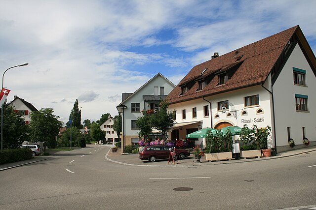
Лауфенбург
- город в Швейцарии, окружной центр, находится в кантоне Аргау
Hiking in Лауфенбург
Laufenburg is a charming town located on the banks of the Rhine River in the Aargau region of Switzerland. It offers a variety of hiking opportunities, suitable for different levels of experience. Here are some highlights and tips for hiking in and around Laufenburg:...
- Страна:
- Почтовый код: 5080
- Телефонный код: 062
- Код автомобильного номера: AG
- Координаты: 47° 33' 39" N, 8° 3' 34" E
- GPS треки (wikiloc): [Ссылка]
- Высота над уровнем моря: 318 м m
- Площадь: 2.28 кв.км
- Население: 3626
- Веб сайт: [Ссылка]
Эшген
Hiking in Эшген
Oeschgen is a beautiful area in Switzerland, particularly known for its stunning landscapes and hiking opportunities. It is located in the canton of Aargau, surrounded by picturesque nature. Here are some highlights and tips for hiking in Oeschgen:...
- Страна:
- Почтовый код: 5072
- Телефонный код: 062
- Код автомобильного номера: AG
- Координаты: 47° 31' 29" N, 8° 1' 1" E
- GPS треки (wikiloc): [Ссылка]
- Высота над уровнем моря: 394 м m
- Площадь: 4.38 кв.км
- Население: 1016
- Веб сайт: [Ссылка]
Мюнхвилен
Hiking in Мюнхвилен
Münchwilen, located in the Aargau canton of Switzerland, offers a variety of scenic hiking opportunities. The region is characterized by picturesque landscapes, lush forests, and charming pastoral views, making it a great destination for both short walks and more extended hikes....
- Страна:
- Почтовый код: 4333
- Телефонный код: 062
- Код автомобильного номера: AG
- Координаты: 47° 32' 19" N, 7° 57' 50" E
- GPS треки (wikiloc): [Ссылка]
- Высота над уровнем моря: 343 м m
- Площадь: 2.47 кв.км
- Население: 936
- Веб сайт: [Ссылка]

Mettauertal
Hiking in Mettauertal
Mettauertal, located in the Aargau region of Switzerland, offers a beautiful setting for hiking enthusiasts. Known for its stunning landscapes, rolling hills, and lush greenery, the area is ideal for outdoor activities. Here are some highlights and tips for hiking in Mettauertal:...
- Страна:
- Почтовый код: 5273, 5274, 5275, 5276, 5277
- Телефонный код: 062
- Код автомобильного номера: AG
- Координаты: 47° 33' 40" N, 8° 7' 57" E
- GPS треки (wikiloc): [Ссылка]
- Высота над уровнем моря: 350 м m
- Площадь: 21.56 кв.км
- Население: 1966
- Веб сайт: [Ссылка]