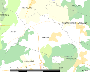
Le Pasquier (Le Pasquier)

- коммуна во Франции
 Hiking in Le Pasquier
Le Pasquier is a wonderful destination for hiking enthusiasts. While the specific region may vary, if you’re referring to a hiking area known as Le Pasquier in France, it is often characterized by stunning natural beauty, picturesque landscapes, and a variety of trails suitable for different skill levels.
Highlights of Hiking in Le Pasquier:
-
Scenic Trails: The hiking trails around Le Pasquier typically offer breathtaking views of the surrounding countryside, including lush forests, rolling hills, and sometimes panoramic vistas of nearby mountain ranges.
-
Diverse Flora and Fauna: Hikers can encounter a rich diversity of plant and animal life. Birdwatchers may particularly enjoy the region, as it's a habitat for various species.
-
Trail Variety: Whether you’re a beginner, intermediate, or advanced hiker, you'll find trails that match your skill level. Always choose a trail that suits your endurance level and preparation.
-
Cultural Points of Interest: Many hiking trails may also lead to historical sites or offer insight into local culture, providing a deeper appreciation of the area’s heritage.
-
Accessibility: Le Pasquier is often accessible from nearby towns, with clearly marked trails and sometimes local guides available to enhance your experience.
Preparation Tips:
- Check Weather Conditions: Be aware of the weather forecast before you set out, as conditions can change rapidly.
- Dress Appropriately: Wear layers and good hiking boots for comfort and safety.
- Stay Hydrated: Carry enough water, especially on longer hikes.
- Trail Maps and Apps: Use reliable maps or hiking apps to navigate the trails.
Local Regulations:
Before hiking in Le Pasquier, check local regulations or park rules to ensure a safe and enjoyable experience. Respect wildlife and nature, and follow Leave No Trace principles.
Conclusion:
Whether you're looking for a leisurely stroll or a rigorous hike, Le Pasquier has something to offer every hiking enthusiast. Always remember to plan ahead, respect nature, and enjoy the journey!
- Страна:

- Почтовый код: 39300
- Координаты: 46° 48' 2" N, 5° 54' 19" E


- GPS треки (wikiloc): [Ссылка]
- Площадь: 7.75 кв.км
- Население: 263
- Веб сайт: http://www.lepasquier.fr
- Википедия английская: wiki(en)
- Википедия национальная: wiki(fr)
- Хранилище Wikidata: Wikidata: Q818539
- Катеория в википедии: [Ссылка]
- код Freebase: [/m/03npzpf]
- код GeoNames: Альт: [6455984]
- номер SIREN: [213904063]
- код BNF: [152587692]
- код муниципалитета INSEE: 39406
Граничит с регионами:


Valempoulières
- коммуна во Франции
Hiking in Valempoulières
Valempoulières is a charming commune located in the Jura department of eastern France. While it may not be one of the most famous hiking destinations, it offers beautiful scenery and opportunities for outdoor activities. Here are some highlights for hiking in and around Valempoulières:...
- Страна:
- Почтовый код: 39300
- Координаты: 46° 49' 33" N, 5° 51' 49" E
- GPS треки (wikiloc): [Ссылка]
- Площадь: 16.25 кв.км
- Население: 213


Moutoux
- коммуна во Франции
Hiking in Moutoux
Moutoux is a beautiful hiking destination located in the Jura region of France. This area is known for its stunning landscapes, rich biodiversity, and a network of well-marked hiking trails....
- Страна:
- Почтовый код: 39300
- Координаты: 46° 47' 28" N, 5° 56' 24" E
- GPS треки (wikiloc): [Ссылка]
- Площадь: 4.27 кв.км
- Население: 68


Ardon
Hiking in Ardon
Ardon, located in the Jura region of Switzerland, offers a range of beautiful hiking opportunities that cater to various skill levels. The Jura mountains are known for their rolling hills, lush forests, and panoramic views. Here are some highlights and tips for hiking in the area:...
- Страна:
- Почтовый код: 39300
- Координаты: 46° 46' 26" N, 5° 53' 17" E
- GPS треки (wikiloc): [Ссылка]
- Площадь: 5.04 кв.км
- Население: 116


Saint-Germain-en-Montagne
- коммуна во Франции
Hiking in Saint-Germain-en-Montagne
Saint-Germain-en-Montagne is a charming village located in the Jura department of France, known for its beautiful natural landscapes, rolling hills, and rich biodiversity, making it an ideal spot for hiking enthusiasts. Here are some highlights and tips for hiking in and around Saint-Germain-en-Montagne:...
- Страна:
- Почтовый код: 39300
- Координаты: 46° 46' 38" N, 5° 56' 23" E
- GPS треки (wikiloc): [Ссылка]
- Площадь: 5.35 кв.км
- Население: 439

Vannoz
- коммуна во Франции
Hiking in Vannoz
It seems like there might be a bit of confusion regarding the name "Vannoz," as it doesn't correspond to a well-known hiking location or trail in major hiking databases or resources. However, it's possible that you might be referring to a specific region, local area, or perhaps a less-known trail that hasn't gained widespread recognition....
- Страна:
- Почтовый код: 39300
- Координаты: 46° 46' 22" N, 5° 55' 1" E
- GPS треки (wikiloc): [Ссылка]
- Площадь: 5.75 кв.км
- Население: 205


Le Latet
- коммуна во Франции
Hiking in Le Latet
Le Latet is a beautiful hiking destination situated in the French Alps, specifically in the Haute-Savoie region. This area is known for its stunning alpine landscapes, picturesque valleys, and diverse flora and fauna. Here are some key highlights and tips for hiking in Le Latet:...
- Страна:
- Почтовый код: 39300
- Координаты: 46° 48' 16" N, 5° 56' 6" E
- GPS треки (wikiloc): [Ссылка]
- Площадь: 4.02 кв.км
- Население: 80

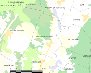
Ве-ан-Монтань
- коммуна во Франции
Hiking in Ве-ан-Монтань
Vers-en-Montagne is a charming commune located in the Jura department of France, nestled amidst stunning natural scenery in the Jura Mountains. It's an excellent destination for hikers seeking beautiful landscapes, tranquility, and a variety of trails catering to different skill levels....
- Страна:
- Почтовый код: 39300
- Координаты: 46° 48' 57" N, 5° 54' 55" E
- GPS треки (wikiloc): [Ссылка]
- Площадь: 8.35 кв.км
- Население: 243


Montrond
Hiking in Montrond
Montrond, located in the Jura mountain range in eastern France, offers a variety of hiking opportunities that embrace the breathtaking natural beauty of the region. Here are some key points to consider:...
- Страна:
- Почтовый код: 39300
- Координаты: 46° 47' 52" N, 5° 49' 56" E
- GPS треки (wikiloc): [Ссылка]
- Площадь: 25.32 кв.км
- Население: 496