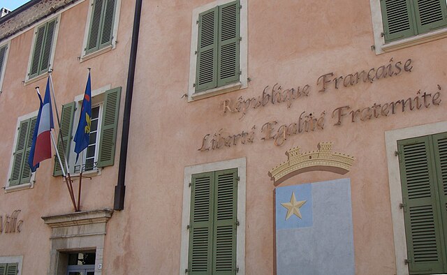
Ле-Тороне (Le Thoronet, Le Thoronet)

- коммуна во Франции
 Hiking in Ле-Тороне
Le Thoronet, located in the Var region of southeastern France, is known for its beautiful natural landscapes, including rolling hills, lush forests, and vineyards. Hiking in Le Thoronet offers a variety of trails suitable for different skill levels, with picturesque views and a chance to explore the region's natural beauty.
Hiking Trails and Features:
-
Sentier des Chapelles: This scenic trail leads adventurers to several historic chapels scattered throughout the area, allowing hikers to soak in both nature and culture.
-
Cistercian Abbey of Le Thoronet: The route can often include visits to the nearby Abbey, which is a remarkable example of Cistercian architecture. The area surrounding the abbey features serene trails that provide a calming hiking experience.
-
Vineyard Paths: The area is surrounded by vineyards, and many trails permit hikers to enjoy the picturesque landscapes and even taste local wines at various points along the route.
-
Natural Environment: Hikers can expect to encounter diverse flora and fauna, with opportunities for bird-watching and enjoying local wildlife. The Mediterranean climate provides mild weather, making it an inviting destination for outdoor activities.
Practical Tips:
-
Best Time to Hike: Spring (April to June) and early autumn (September to October) are optimal times for hiking, as the weather is mild and the landscape is vibrant.
-
Trail Maps: It’s advisable to pick up a trail map or use a navigation app to stay on designated paths, as some trails may not be well-marked. Local tourism offices can provide useful resources.
-
Equipment: Wear sturdy hiking boots, and dress in layers to accommodate changes in temperature. Carry enough water and snacks, especially on longer hikes.
-
Safety: Always let someone know about your hiking plans, and consider hiking with a partner, especially on less-traveled paths.
-
Respect Nature: Follow the Leave No Trace principles to minimize your impact on the environment. This includes staying on marked trails, packing out any trash, and respecting wildlife.
Whether you're a novice hiker or an experienced outdoors-person, the trails around Le Thoronet offer opportunities to appreciate the region’s scenic landscapes and historical significance. Enjoy your hiking experience!
- Страна:

- Почтовый код: 83340
- Координаты: 43° 27' 7" N, 6° 18' 14" E


- GPS треки (wikiloc): [Ссылка]
- Площадь: 37.53 кв.км
- Население: 2442
- Веб сайт: http://www.lethoronet.fr
- Википедия русская: wiki(ru)
- Википедия английская: wiki(en)
- Википедия национальная: wiki(fr)
- Хранилище Wikidata: Wikidata: Q848676
- Катеория в википедии: [Ссылка]
- код Freebase: [/m/03qhfj0]
- код GeoNames: Альт: [2999179]
- номер SIREN: [218301364]
- код BNF: [15277963q]
- код VIAF: Альт: [133712870]
- код GND: Альт: [4379677-1]
- идентификатор местоположения ArchINFORM: [11376]
- код LCNAF: Альт: [n82070375]
- код тезауруса PACTOLS: [pcrtzXryY3JAgu]
- код муниципалитета INSEE: 83136
Граничит с регионами:

Карсес
- коммуна во Франции
Hiking in Карсес
Carcès is a charming village located in the Var department in the Provence-Alpes-Côte d'Azur region of southeastern France. It is set amidst picturesque landscapes, making it a fantastic destination for hiking enthusiasts. Here are some highlights about hiking in the area:...
- Страна:
- Почтовый код: 83570
- Координаты: 43° 28' 34" N, 6° 10' 58" E
- GPS треки (wikiloc): [Ссылка]
- Площадь: 35.76 кв.км
- Население: 3463
- Веб сайт: [Ссылка]


Ле-Канне-де-Мор
- коммуна во Франции
Hiking in Ле-Канне-де-Мор
Le Cannet-des-Maures, located in the Var department of the Provence-Alpes-Côte d'Azur region in southeastern France, offers a variety of hiking opportunities that showcase the beautiful landscapes of the area. The town is situated near the lush hills of the Maures Massif, which is known for its dense forests, Mediterranean scrub, and stunning views of the surrounding countryside....
- Страна:
- Почтовый код: 83340
- Координаты: 43° 23' 30" N, 6° 20' 27" E
- GPS треки (wikiloc): [Ссылка]
- Площадь: 73.64 кв.км
- Население: 4356


Лорг
- коммуна во Франции
Hiking in Лорг
Lorgues, a picturesque village located in the Var department of the Provence-Alpes-Côte d'Azur region in southeastern France, offers several opportunities for hiking enthusiasts. The surrounding landscapes feature rolling hills, vineyards, olive groves, and dense forests, making it a beautiful backdrop for outdoor activities....
- Страна:
- Почтовый код: 83510
- Координаты: 43° 29' 36" N, 6° 21' 40" E
- GPS треки (wikiloc): [Ссылка]
- Площадь: 64.37 кв.км
- Население: 9042
- Веб сайт: [Ссылка]


Антрекасто
- коммуна во Франции
Hiking in Антрекасто
Entrecasteaux is a picturesque region located in the Var department of Provence-Alpes-Côte d'Azur in southeastern France. Known for its beautiful landscapes, rolling hills, and vineyards, it offers a range of hiking opportunities suitable for various skill levels. Here are some highlights and tips for hiking in the Entrecasteaux area:...
- Страна:
- Почтовый код: 83570
- Координаты: 43° 30' 57" N, 6° 14' 31" E
- GPS треки (wikiloc): [Ссылка]
- Площадь: 32.11 кв.км
- Население: 1105


Ле-Люк
- коммуна во Франции
Hiking in Ле-Люк
Le Luc, located in the Var department of the Provence-Alpes-Côte d'Azur region in southeastern France, offers a variety of hiking opportunities for outdoor enthusiasts. While Le Luc itself is a small town, it is surrounded by beautiful landscapes, vineyards, and natural parks that provide excellent hiking trails....
- Страна:
- Почтовый код: 83340
- Координаты: 43° 23' 41" N, 6° 18' 46" E
- GPS треки (wikiloc): [Ссылка]
- Площадь: 44.16 кв.км
- Население: 10821
- Веб сайт: [Ссылка]

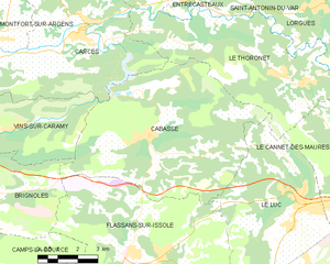
Кабас
- коммуна во Франции
Hiking in Кабас
Cabasse, a quaint village in the Var region of Provence-Alpes-Côte d'Azur in southeastern France, offers a variety of hiking opportunities amidst beautiful natural settings. Here are some highlights to consider if you're planning to hike in and around Cabasse:...
- Страна:
- Почтовый код: 83340
- Координаты: 43° 25' 34" N, 6° 13' 19" E
- GPS треки (wikiloc): [Ссылка]
- Площадь: 45.49 кв.км
- Население: 1918
- Веб сайт: [Ссылка]


Сент-Антонен-дю-Вар
- коммуна во Франции
Hiking in Сент-Антонен-дю-Вар
Saint-Antonin-du-Var, located in the Var department of Provence-Alpes-Côte d'Azur in France, is a charming destination for hikers looking to explore the beautiful landscapes of the region. Here are some highlights you can expect when hiking in and around this picturesque village:...
- Страна:
- Почтовый код: 83510
- Координаты: 43° 30' 24" N, 6° 17' 13" E
- GPS треки (wikiloc): [Ссылка]
- Площадь: 17.64 кв.км
- Население: 748
- Веб сайт: [Ссылка]