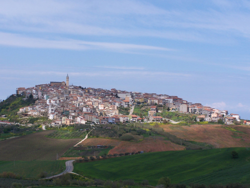
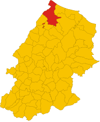
Лентелла (Lentella, Lentella)
.svg)
- коммуна Италии
 Hiking in Лентелла
Lentella, a charming village located in the Abruzzo region of Italy, offers breathtaking landscapes and a variety of hiking opportunities for both novice and experienced hikers. The surrounding area features rolling hills, picturesque valleys, and stunning views of the Majella and Gran Sasso mountains, making it a great destination for outdoor enthusiasts.
Hiking Trails:
-
Local Trails: The area around Lentella has several well-marked trails that allow you to explore the countryside. Many trails lead you through vineyards and olive groves, providing a unique glimpse into local agricultural practices.
-
Majella National Park: A short drive from Lentella, this park offers a range of trails suited for different skill levels. The park is known for its diverse flora and fauna, rugged peaks, and breathtaking panoramas.
-
Gran Sasso e Monti della Laga National Park: Another nearby national park worth exploring, it features stunning mountain landscapes, glacial lakes, and an extensive network of trails.
Preparing for Your Hike:
- Terrain: Be prepared for a mix of terrains, including rocky paths and dirt trails. Good hiking boots are essential.
- Weather: The weather can change quickly in the mountains, so dressing in layers is advised. Be sure to check the forecast before heading out.
- Trail Maps: Carrying a trail map or downloading a hiking app can help you navigate the area and discover points of interest.
Safety Tips:
- Always let someone know your hiking plans.
- Carry plenty of water and snacks.
- Be aware of your surroundings and wildlife.
- Familiarize yourself with the local flora and fauna, as some plants may be toxic.
Conclusion:
Hiking in Lentella provides an opportunity to immerse yourself in beautiful natural surroundings while enjoying a peaceful escape from the hustle and bustle of daily life. Whether you're interested in short walks or more challenging hikes, you'll find something to suit your preferences in this picturesque region of Italy.
- Страна:

- Почтовый код: 66050
- Телефонный код: 0873
- Код автомобильного номера: CH
- Координаты: 42° 0' 0" N, 14° 41' 0" E


- GPS треки (wikiloc): [Ссылка]
- Высота над уровнем моря: 398 м m
- Площадь: 12.62 кв.км
- Население: 714
- Веб сайт: http://comunedilentella.it/
- Википедия русская: wiki(ru)
- Википедия английская: wiki(en)
- Википедия национальная: wiki(it)
- Хранилище Wikidata: Wikidata: Q51245
- Катеория в википедии: [Ссылка]
- код Freebase: [/m/0fg2m3]
- код GeoNames: Альт: [6541229]
- ID отношения в OpenStreetMap: [41700]
- код ISTAT: 069047
- кадастровый код Италии: E531
Граничит с регионами:
Мафальда
- коммуна Италии
Hiking in Мафальда
Mafalda is a small town located in the Molise region of Italy, known for its picturesque landscapes and charming rural setting. Hiking in and around Mafalda offers a unique opportunity to explore the natural beauty of southern Italy, characterized by rolling hills, lush countryside, and panoramic views....
- Страна:
- Почтовый код: 86030
- Телефонный код: 0875
- Код автомобильного номера: CB
- Координаты: 41° 57' 0" N, 14° 43' 0" E
- GPS треки (wikiloc): [Ссылка]
- Высота над уровнем моря: 460 м m
- Площадь: 32.61 кв.км
- Население: 1184
- Веб сайт: [Ссылка]
Монтенеро-ди-Бизачча
- коммуна Италии
Hiking in Монтенеро-ди-Бизачча
Montenero di Bisaccia is a charming town located in the Molise region of Italy, known for its beautiful landscapes and outdoor activities, including hiking. The area offers a unique blend of rolling hills, coastal views, and rustic countryside, making it an attractive spot for hikers seeking both tranquility and scenic beauty....
- Страна:
- Почтовый код: 86036
- Телефонный код: 0875
- Код автомобильного номера: CB
- Координаты: 41° 57' 0" N, 14° 47' 0" E
- GPS треки (wikiloc): [Ссылка]
- Высота над уровнем моря: 273 м m
- Площадь: 93.32 кв.км
- Население: 6612
- Веб сайт: [Ссылка]


Купелло
- коммуна Италии
Hiking in Купелло
Cupello, located in the Abruzzo region of Italy, is a charming spot for hiking enthusiasts. While it may not be as famous as other hiking destinations in Italy, it offers beautiful landscapes and trails that allow you to experience the natural beauty of the region....
- Страна:
- Почтовый код: 66051
- Телефонный код: 0873
- Код автомобильного номера: CH
- Координаты: 42° 4' 0" N, 14° 40' 0" E
- GPS треки (wikiloc): [Ссылка]
- Высота над уровнем моря: 380 м m
- Площадь: 48.39 кв.км
- Население: 4832
- Веб сайт: [Ссылка]


Фрезаграндинария
- коммуна Италии
Hiking in Фрезаграндинария
Fresagrandinaria is a picturesque location in the Abruzzo region of Italy, surrounded by beautiful natural landscapes, dense forests, and striking mountain scenery. It is part of the larger area known for its outdoor recreational opportunities, particularly hiking....
- Страна:
- Почтовый код: 66050
- Телефонный код: 0873
- Код автомобильного номера: CH
- Координаты: 41° 59' 0" N, 14° 40' 0" E
- GPS треки (wikiloc): [Ссылка]
- Высота над уровнем моря: 460 м m
- Площадь: 25.15 кв.км
- Население: 946
- Веб сайт: [Ссылка]