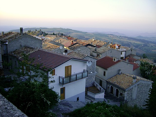
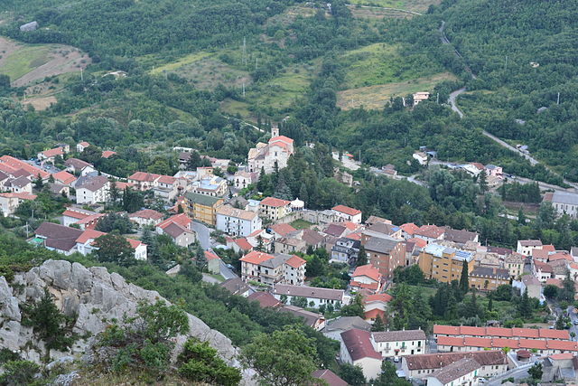
Леттопалена (Lettopalena, Lettopalena)
.svg)
- коммуна Италии
 Hiking in Леттопалена
Lettopalena is a charming village located in the Abruzzo region of Italy, surrounded by stunning natural landscapes, mountains, and historical sites. Hiking in and around Lettopalena offers a rich experience due to the diverse terrain, scenic views, and opportunities to explore the local flora and fauna.
Key Hiking Areas
-
Majella National Park: Just a short distance from Lettopalena, this national park offers numerous trails that vary in difficulty. The park is known for its rugged mountains, deep gorges, and beautiful wildlife. Popular hikes include routes to peaks like Monte Amaro and the stunning Valle dell'Orfento.
-
The Gorges of the Orfento River: This area features spectacular trails that take you along the Orfento River, through lush vegetation and impressive rock formations. The trails here offer both leisurely walks and more challenging hikes, with opportunities for photography and birdwatching.
-
Local Trails: Within the vicinity of Lettopalena, there are several local trails that allow you to explore the picturesque countryside, ancient ruins, and traditional Abruzzese villages. These trails often lead you through vineyards and olive groves, giving you a taste of local culture.
Tips for Hiking in Lettopalena
-
Preparation: Always check the weather forecast and trail conditions before heading out. It’s advisable to carry a map or a GPS device, as some trails can be less marked.
-
Gear: Wear appropriate footwear and bring enough water and snacks. The terrain can vary, so consider bringing trekking poles for added stability on rocky paths.
-
Safety: Inform someone about your hiking plans, especially if you are venturing into more remote areas. Keep an eye out for wildlife, and respect local regulations regarding nature conservation.
-
Guided Tours: If you’re unfamiliar with the area, consider joining a guided hiking tour. Local guides can provide insights into the natural and cultural history of the region, making your experience even more enriching.
Best Time to Hike
The best time to hike in Lettopalena is during the spring (April to June) and early autumn (September to October) when the weather is mild, and the landscapes are vibrant. Summer can be hot, while winter is ideal for snowfall enthusiasts but may limit some hiking options.
Hiking in Lettopalena and its surroundings offers a unique opportunity to immerse yourself in the natural beauty of Italy, making it an excellent destination for both novice and experienced hikers.
- Страна:

- Почтовый код: 66010
- Телефонный код: 0872
- Код автомобильного номера: CH
- Координаты: 42° 0' 0" N, 14° 10' 0" E


- GPS треки (wikiloc): [Ссылка]
- Высота над уровнем моря: 680 м m
- Площадь: 21.13 кв.км
- Население: 339
- Веб сайт: http://www.comunelettopalena.it/
- Википедия русская: wiki(ru)
- Википедия английская: wiki(en)
- Википедия национальная: wiki(it)
- Хранилище Wikidata: Wikidata: Q51246
- Катеория в википедии: [Ссылка]
- код Freebase: [/m/0fg31l]
- код GeoNames: Альт: [6541705]
- код VIAF: Альт: [142080652]
- ID отношения в OpenStreetMap: [41691]
- код ISTAT: 069048
- кадастровый код Италии: E559
Граничит с регионами:
Колледимачине
- коммуна Италии
Hiking in Колледимачине
Colledimacine, located in the Abruzzo region of Italy, is a fantastic destination for hiking enthusiasts. Nestled within the Gran Sasso e Monti della Laga National Park, it offers breathtaking landscapes, diverse ecosystems, and a variety of hiking trails suitable for different skill levels....
- Страна:
- Почтовый код: 66010
- Телефонный код: 0872
- Код автомобильного номера: CH
- Координаты: 42° 0' 0" N, 14° 12' 0" E
- GPS треки (wikiloc): [Ссылка]
- Высота над уровнем моря: 770 м m
- Площадь: 11.3 кв.км
- Население: 188
- Веб сайт: [Ссылка]

Монтенеродомо
- коммуна Италии
Hiking in Монтенеродомо
Montenerodomo is a charming village located in the Abruzzo region of Italy, surrounded by stunning natural landscapes that are perfect for hiking enthusiasts. Here are some key points to consider if you're thinking about hiking in and around Montenerodomo:...
- Страна:
- Почтовый код: 66010
- Телефонный код: 0872
- Код автомобильного номера: CH
- Координаты: 41° 59' 0" N, 14° 15' 0" E
- GPS треки (wikiloc): [Ссылка]
- Высота над уровнем моря: 1165 м m
- Площадь: 30 кв.км
- Население: 656
- Веб сайт: [Ссылка]


Палена
- коммуна Италии
Hiking in Палена
Palena, located in the Abruzzo region of Italy, is a hidden gem for hikers and nature enthusiasts. Nestled in the Majella National Park, it offers stunning landscapes, diverse flora and fauna, and a range of hiking trails suitable for all skill levels....
- Страна:
- Почтовый код: 66017
- Телефонный код: 0872
- Код автомобильного номера: CH
- Координаты: 41° 58' 54" N, 14° 8' 3" E
- GPS треки (wikiloc): [Ссылка]
- Высота над уровнем моря: 767 м m
- Площадь: 93.63 кв.км
- Население: 1332
- Веб сайт: [Ссылка]

Таранта-Пелинья
- коммуна Италии
Hiking in Таранта-Пелинья
Taranta Peligna is a quaint village located in the Abruzzo region of Italy, surrounded by stunning natural landscapes that make it a great destination for hiking enthusiasts. The area boasts a mix of rolling hills, mountainous terrain, and picturesque views, making it ideal for various hiking experiences....
- Страна:
- Почтовый код: 66018
- Телефонный код: 0872
- Код автомобильного номера: CH
- Координаты: 42° 1' 0" N, 14° 10' 0" E
- GPS треки (wikiloc): [Ссылка]
- Высота над уровнем моря: 460 м m
- Площадь: 21.9 кв.км
- Население: 353
- Веб сайт: [Ссылка]