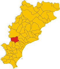
Лоано (Loano, Loano)
.svg)
- коммуна Италии
 Hiking in Лоано
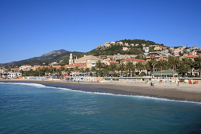
Loano is a charming coastal town located on the Italian Riviera in the Liguria region. It offers a variety of hiking opportunities that cater to different skill levels and preferences. Here are some highlights of hiking in and around Loano:
Trails and Areas
-
Monte Carmo: This mountain is one of the highest in the area and offers several hiking trails with varying degrees of difficulty. The views from the summit are breathtaking, providing panoramic views of the coastline and surrounding hills.
-
Beigua Regional Park: Located just a short drive from Loano, this protected area offers numerous well-marked hiking trails through beautiful natural landscapes, including forests, meadows, and rocky outcrops. The biodiversity here is impressive, and you may encounter various wildlife along your hike.
-
The Coastal Trail (Sentiero Liguria): This trail runs along the coastline and connects several towns, including Loano. It's a relatively easy hike, perfect for those looking to enjoy scenic views of the sea. The cliffs and beaches along the way make for great stopping points.
-
Via Ferrata: For more adventurous hikers, there are via ferrata routes in the nearby mountains, which offer the thrill of climbing with the safety of fixed cables and ladders.
Tips for Hiking in Loano
-
Best Time to Hike: The spring and fall are ideal for hiking due to mild weather and fewer crowds. Summers can be hot, while winters are relatively mild but can be rainy.
-
Local Amenities: Loano has good accessibility to shops and restaurants. Make sure to stock up on water and snacks before heading out, especially for longer hikes.
-
Safety: Always check the weather before heading out. It's best to hike with a partner if possible and to let someone know your plans.
-
Wildlife and Flora: Keep an eye out for the local flora and fauna! The region is home to various plant species and wildlife, making hikes an engaging experience.
-
Guided Tours: If you prefer a more structured experience, consider joining local guided tours that can give you insights into the area’s natural and cultural history.
Accessibility
Loano is well-connected by public transportation, making it easy to access trails in surrounding areas. You can also find local rental shops for trekking equipment if you need any gear.
Whether you are looking for challenging hikes or leisurely walks with stunning coastal views, Loano offers something for every hiking enthusiast. Enjoy your outdoor adventure!
- Страна:

- Почтовый код: 17025
- Телефонный код: 019
- Код автомобильного номера: SV
- Координаты: 44° 7' 44" N, 8° 15' 35" E


- GPS треки (wikiloc): [Ссылка]
- Высота над уровнем моря: 5 м m
- Площадь: 13.48 кв.км
- Население: 11224
- Веб сайт: http://www.comuneloano.it
- Википедия русская: wiki(ru)
- Википедия английская: wiki(en)
- Википедия национальная: wiki(it)
- Хранилище Wikidata: Wikidata: Q270782
- Галерея изображений в википедии: [Ссылка]
- Катеория в википедии: [Ссылка]
- код Freebase: [/m/0gbzv2]
- код GeoNames: Альт: [6536083]
- код VIAF: Альт: [133839005]
- ID отношения в OpenStreetMap: [42897]
- UN/LOCODE: [ITLOA]
- код в Большой каталанской энциклопедии: [0038295]
- код ISTAT: 009034
- кадастровый код Италии: E632
Граничит с регионами:

Бардинето
- коммуна Италии
Hiking in Бардинето
Bardineto is a picturesque village located in the Liguria region of Italy, nestled within the lush countryside of the province of Savona. The area is characterized by its stunning natural landscapes, rolling hills, and mountainous terrain, making it an excellent destination for hiking enthusiasts....
- Страна:
- Почтовый код: 17057
- Телефонный код: 019
- Код автомобильного номера: SV
- Координаты: 44° 11' 32" N, 8° 7' 45" E
- GPS треки (wikiloc): [Ссылка]
- Высота над уровнем моря: 711 м m
- Площадь: 29.79 кв.км
- Население: 744
- Веб сайт: [Ссылка]


Бойссано
- коммуна Италии
Hiking in Бойссано
Boissano is a quaint Italian village located in the Liguria region, close to the coastline of the Mediterranean Sea. The area around Boissano is known for its stunning landscapes, which include picturesque hills, valleys, and coastal views, making it an excellent destination for hiking enthusiasts of all levels....
- Страна:
- Почтовый код: 17054
- Телефонный код: 0182
- Код автомобильного номера: SV
- Координаты: 44° 8' 4" N, 8° 13' 17" E
- GPS треки (wikiloc): [Ссылка]
- Высота над уровнем моря: 121 м m
- Площадь: 8.35 кв.км
- Население: 2474
- Веб сайт: [Ссылка]


Боргетто-Санто-Спирито
- коммуна Италии
Hiking in Боргетто-Санто-Спирито
Borghetto Santo Spirito is a charming coastal village located in the Liguria region of Italy, near the western part of the Italian Riviera. While it is primarily known for its beautiful beaches and pleasant climate, there are also opportunities for hiking and exploring the surrounding natural landscapes....
- Страна:
- Почтовый код: 17052
- Телефонный код: 0182
- Код автомобильного номера: SV
- Координаты: 44° 6' 33" N, 8° 14' 29" E
- GPS треки (wikiloc): [Ссылка]
- Высота над уровнем моря: 2 м m
- Площадь: 5.39 кв.км
- Население: 4802
- Веб сайт: [Ссылка]


Джустениче
- коммуна Италии
Hiking in Джустениче
Giustenice, a small town located in the Province of Savona in the Italian region of Liguria, offers a range of beautiful hiking opportunities. The surrounding landscapes feature rolling hills, olive groves, and Mediterranean vegetation, making it an excellent destination for nature enthusiasts and hikers....
- Страна:
- Почтовый код: 17027
- Телефонный код: 019
- Код автомобильного номера: SV
- Координаты: 44° 10' 20" N, 8° 14' 46" E
- GPS треки (wikiloc): [Ссылка]
- Высота над уровнем моря: 140 м m
- Площадь: 17.22 кв.км
- Население: 998
- Веб сайт: [Ссылка]

Пьетра-Лигуре
- коммуна Италии
Hiking in Пьетра-Лигуре
Pietra Ligure is a charming coastal town located in the Liguria region of northwest Italy, known for its beautiful beaches and picturesque landscapes. Hiking in and around Pietra Ligure offers stunning views of the Mediterranean Sea, lush vegetation, and the rugged terrain of the surrounding hills....
- Страна:
- Почтовый код: 17027
- Телефонный код: 019
- Код автомобильного номера: SV
- Координаты: 44° 8' 55" N, 8° 16' 58" E
- GPS треки (wikiloc): [Ссылка]
- Высота над уровнем моря: 3 м m
- Площадь: 9.88 кв.км
- Население: 8837
- Веб сайт: [Ссылка]